Fracture patterns and their origin in the Upper Devonian Antrim Shale gas reservoir of the Michigan basin: A review
Robert T. Ryder
Open-File Report 96-23
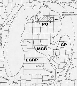
Figure 6 Michigan basin and adjoining areas showing Proterozoic basement provinces and major structures (Budai and Wilson (1991). PO-Penokean Orogen; EGRP-Eastern Granite-Rhyolite Province; MCR-Midcontinent Rift System; GP, Grenville Province; HA-Howell anticline; L-Lucas fault; M-Monroe fault; BG-Bowling Green fault; AS-Albion Scipio oil field; SP-Stoney Point oil field; 1*-McClure No. 1 Sparks well. (TD=17,466 ft). Dotted line outlines the Michigan basin.
 |
![]()
![]()
Created by the EERT WWW Staff.
[an error occurred while processing this directive]