Digitally Compiled By John Tully
Introduction:
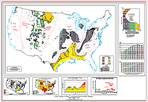 "Coal
Fields of the Conterminous United States" is a digital
representation of James Trumbull's "Coal Fields of the
United States" (sheet 1, 1960), which is an adaptation of
previous maps by Averitt (1942) and Campbell(1908). It is
intended to be the first in a series of open file reports that
will eventually result in an I-series map that conforms to the
U.S. Geological Survey mapping standards. For this edition, coal
boundaries were digitized from Trumbull and plotted to represent
as closely as possible the original map. In addition, the Gulf
Province was updated using generalized boundaries of coal bearing
formations digitized from various state geological maps. Goals of
future editions include: updated boundaries for the other Coal
Provinces, reintroduction of an overburden category, updated
field and region names, inclusion of additional cultural and
natural features such as rivers, county names, major highways,
and coal-fired power plants.
"Coal
Fields of the Conterminous United States" is a digital
representation of James Trumbull's "Coal Fields of the
United States" (sheet 1, 1960), which is an adaptation of
previous maps by Averitt (1942) and Campbell(1908). It is
intended to be the first in a series of open file reports that
will eventually result in an I-series map that conforms to the
U.S. Geological Survey mapping standards. For this edition, coal
boundaries were digitized from Trumbull and plotted to represent
as closely as possible the original map. In addition, the Gulf
Province was updated using generalized boundaries of coal bearing
formations digitized from various state geological maps. Goals of
future editions include: updated boundaries for the other Coal
Provinces, reintroduction of an overburden category, updated
field and region names, inclusion of additional cultural and
natural features such as rivers, county names, major highways,
and coal-fired power plants.
Select the thumbnail map above to download a full size version (6.8 mb) of this map. You will need Adobe Acrobat Reader 4.0 to view this file.
Selected References:
General:
ASTM, 1995, Standard Classification of Coals by Rank (Designation D388-95): 1995 Annual Book of ASTM Standards, v. 5.05, p. 168-171.
Averitt, P., 1942, Coal Fields of the United States: U. S. Geological Survey map, scale 1:2,500,000.
Campbell, M., 1908, Coal Fields of the United States: U. S. Geological Survey map, scale 1:7,500,000.
Trumbull, J., 1960, Coal Fields of the United
States (sheet 1): U. S. Geological Survey map, scale
1:5,000,000.
Gulf Province revisions:
Anderson, K. H., 1979, Geologic Map of Missouri: Missouri Geological Survey, scale 1:500,000.
Belt, W. E., et al, 1945, Geologic Map Mississippi: Mississippi Geological Society and U. S. Geological Survey, scale 1:500,000.
Cope, D. E., et al, 1984, Geologic Map of Louisiana: Louisiana Geological Survey, scale 1:500,000.
Haley, B. R., 1976, Geologic Map of Arkansas:
Arkansas Geological Commission and U. S. Geological
Survey, scale 1:500,000.
Hartmann, B. M., and Scranton, D. F., 1992, Geologic Map of Texas (southwest, southeast, northeast quadrants): Bureau of Economic Geology at The University of Texas at Austin, scale 1:500,000.
Lawton, D. E., et al, 1976, Geologic Map of
Georgia: Georgia Department of Natural Resources and
Georgia Geological Survey, scale 1:500,000.
McDowell, R. C., Grabowski, G. J., Moore, S. L., 1981, Geologic Map of Kentucky (sheet1): U. S. Geological Survey and 11th Kentucky Geological Survey, scale 1:250,000.
Miller, R. A., Hardeman, W. D., and Fullerton, D. S, 1966, Geologic Map of Tennessee (west sheet): Tennessee Department of Conservation Division of Geology, scale 1:250,000.
Osborne, W. E., Szabo, M. W., Copeland, C. W., and Neathery, T. L., 1989, Geologic Map of Alabama: Geological Survey of Alabama, scale 1:500,000.
Wood, G. H., and Bour, W. V., 1988, Coal Map of
North America (south half): U. S. Geological Survey
map, scale 1:5,000,000.
US Coal Production by State: 1995 (map):
US Coal Production by Year (graph):
Coal Production 1987: Department of Energy, Energy Information Administration,1988, table B1, p. 110.
Coal Production 1990: Department of Energy, Energy Information Administration,1991, table B1, p. 78.
Coal Industry Annual 1994: Department of Energy, Energy Information Administration,1995, table 1, p. 5.
Weekly Coal Production for Week Ended 2/10/96: Department of Energy, Energy Information Administration,1996, table 1, p. 3.
Minerals Yearbook 1960: United States Bureau of Mines, v. 2 Fuels, 1961, p. 51-52, 154-155.
Mean Total Sulfur and Calorific Value of Raw Coal Samples by Major Coal Regions in the U. S. (graph):
Data obtained from U. S. Geological Survey National Coal Resources Data System.
Sue Tewalt
MS 956 USGS National Center
Reston, Virginia 20192
stewalt@usgs.gov
Created by the EERT WWW Staff.
[an error occurred while processing this directive]