U.S. Geological Survey Open-File Report 96–252
This Open-File report is a digital geologic map database. This pamphlet serves to introduce and describe the digital data. There is no paper map included in the Open-File report. The report does include, however, files containing images of a geologic map sheet and an explanation sheet. For those interested in a paper plot of information contained in the database, PDFs are provided.
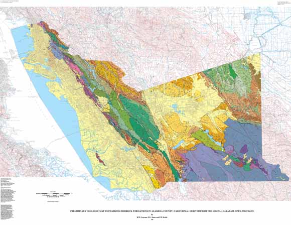
This digital map database, compiled from previously open-filed U.S. Geological Survey reports (Graymer and others, 1994), other published and unpublished data (see Sources of Data in algeo.txt in the data package), and substantial new mapping by the authors in about two-thirds of the county, represents the general distribution of rocks and geologic structures in Alameda County. Together with the accompanying text file (algeo.txt), it provides current information on the stratigraphy and structural geology of the area covered. The database delineates map units that are identified by general age and lithology following the stratigraphic nomenclature of the U.S. Geological Survey. Quaternary units are almost all combined into an undifferentiated unit, with the exception of some artificial deposits (Qar), some early Holocene or late Pleistocene gravel deposits (Qt, Qoa) and a few large landslides (Qls). More specific information about the units may be available in the original publications. The scale of the source maps limits the spatial resolution (scale) of the database to 1:50,000 or smaller.
Files available for downloading:
View the Digital Database ReadMe file (60 kB).
View the database explanation pamphlet as a PDF: aldb.pdf (508 kB).
View the geologic explanation pamphlet as a PDF file: algeo.pdf (100 kB)
View the geologic map sheet as a JPEG file: almap.jpg (592 kB).
View the geologic map sheet as a PDF file: almap.pdf (5.8 MB)
View the geologic explanation sheet as a PDF file: alexpl.pdf (936 kB)
Download a compressed tar file containing the dataset in ARC/INFO 6.x coverage format: al_g1.tar.Z (14.8 MB compressed download file, 97 MB uncompressed)
For additional information:
Contact Information, Western Region Geology and Geophysics Science Center—Menlo Park
U.S. Geological Survey
345 Middlefield Road, MS-973
Menlo Park, CA 94025-3591
http://geomaps.wr.usgs.gov/
Graymer, R.W., Jones, D.L., and Brabb, E.E., 1996, Preliminary geologic map emphasizing bedrock formations in Alameda County, California; a digital database: U.S. Geological Survey Open-File Report 96–252, available at https://pubs.usgs.gov/of/1996/of96-252/.
This report is presented in Portable Document Format (PDF); the latest version of Adobe Reader or similar software is required to view it. Download the latest version of Adobe Reader, free of charge.
Last modified April 18, 2012
First posted May 28, 1996

![]() U.S. Department of the Interior |
U.S. Geological Survey
U.S. Department of the Interior |
U.S. Geological Survey
URL: http://pubsdata.usgs.gov/pubs/of/1996/of96-252/index.html
Page Contact Information: GS Pubs Web Contact
Page Last Modified: Wednesday, 07-Dec-2016 16:05:15 EST
