U.S. Geological Survey Open-File Report 96–737
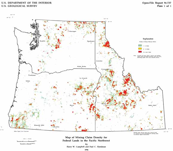
This report describes the contents of a digital dataset (approximately 25 MB) which consists of ARC/INFO Export format files and associated macro programs. The dataset includes a mining claim density map of the Pacific Northwest (Idaho, Oregon, and Washington). This data was acquired from the Bureau of Land Management in September 1994. The user may analyze the four types of mining claims—lode, placer, mill, and tunnel. “Open” vs. “Closed” claims are also two other categories that can be researched. "Open" claims are those actively held when the data was acquired. “Closed” claims are those no longer held by claimants.
Files available for downloading:
View ReadMe file: (56 kb).
Download Open-File Report 96-737 as a PDF file (400 kb).
Download the Dataset in compressed (*.e00.Z) Arc/Info Export format: (5.7 MB download file, 22.2 MB uncompressed).
Download Additional Datasets needed to re-create the paper map in a GIS. This file is in UNIX compressed tar format (*.tar.Z) and includes 5 coverages in Arc/Info Export format (169 kb download, 452 kb uncompressed).
Download Text and AML files needed to re-create the paper map in a GIS. This file is in UNIX compressed tar format (*.tar.Z) with 7 ASCII files that include Arc/Info plot AMLs, key files, and explanatory text (11 kb download, 38 kb uncompressed).
Download map prepared from the digital dataset, in compressed (*.hp.Z) HPGL2 format: (668 kb download file, 2.2 MB uncompressed). The map scale is 1:2,000,000. Map sheet size is approximately 26 by 30 inches. The maps are oriented with the long axis in the x-direction for plotting. This map was designed to be plotted on a HP Inkjet Plotter (model 650-C), but can be plotted on any full-color (inkjet or electrostatic) plotter that will accept HPGL2 code.
For additional information:
Contact Information, Geology, Minerals, Energy, and Geophysics Science Center
Mineral and Environmental Resources, Spokane Office
U.S. Geological Survey
904 W. Riverside Ave., Room 202
Spokane, WA 99201
http://minerals.usgs.gov/west/
Campbell, H.W., and Hyndman, P.C., 1996, Digital mining claim density map for Federal Lands in the Pacific Northwest: U.S. Geological Survey Open-File Report 96–737. (Available at https://pubs.usgs.gov/of/1996/of96-737/.)
Part of this report is presented in Portable Document Format (PDF); the latest version of Adobe Reader or similar software is required to view it. Download the latest version of Adobe Reader, free of charge.
Last modified July 3, 2012
First posted 1996

![]() U.S. Department of the Interior |
U.S. Geological Survey
U.S. Department of the Interior |
U.S. Geological Survey
URL: http://pubsdata.usgs.gov/pubs/of/1996/of96-737/index.html
Page Contact Information: GS Pubs Web Contact
Page Last Modified: Wednesday, 07-Dec-2016 16:05:11 EST
