 The Earthquake and Its Impacts
| Executive Summary | Table of Contents | Geologic Hazards |
The Earthquake and Its Impacts
At 4:30 on the morning of January 17, 1994, some 10 million people in the Los Angeles region of southern California were awakened by the shaking of an earthquake. The earthquake, named for its epicenter in the town of Northridge, was a magnitude 6.7 (M = 6.7) shock that proved to be the most costly earthquake in United States history. The shaking heavily damaged communities throughout the San Fernando Valley and Simi Valley, and their surrounding mountains north and west of Los Angeles, causing estimated losses of 20 billion dollars. Fifty-seven people died, more than 9,000 were injured, and more than 20,000 were displaced from their homes by the effects of the quake. Although moderate in size, the earthquake had immense impact on people and structures because it was centered directly beneath a heavily populated and built-up urban region. Thousands of buildings were significantly damaged, and more than 1,600 were later red-tagged as unsafe to enter. Another 7,300 buildings were restricted to limited entry (yellow-tagged), and many thousands of other structures incurred at least minor damage. The 10-20 seconds of strong shaking collapsed buildings, brought down freeway interchanges, and ruptured gas lines that exploded into fires. Fortuitously, the early morning timing of the earthquake spared many lives that otherwise might have been lost in collapsed parking buildings and on failed freeway structures.
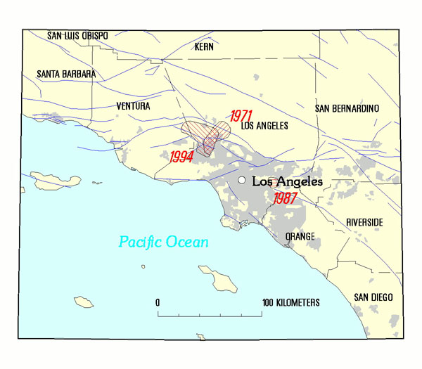
| The 1994 Northridge earthquake (M = 6.7) occurred in a heavily populated urban area northwest of Los Angeles, and had many similarities to the 1971 San Fernando earthquake (M = 6.7). The 1987 Whittier Narrows earthquake (M=5.9), like the Northridge shock, occurred on a buried, previously unknown fault. The three shocks and their effects on the surrounding urbanized areas (grey) are compared throughout this report. |
The Early Response -- Collecting Information and Organizing Communications
Scientists of the U.S. Geological Survey (USGS) responded quickly to the Northridge earthquake, many arriving on the day of the quake to investigate and report on its geological and engineering effects. Early on January 17, the USGS office at the California Institute of Technology (Caltech) in Pasadena became the center for information processing. The network of seismic instruments for monitoring earthquakes in southern California is operated jointly with the USGS at Caltech and, within minutes of the main shock, scientists were analyzing data and broadcasting information about the quake to the public. Scientists maintained a steady flow of public information over the next few days as details about the earthquake and its effects were gleaned from seismic data and observed by field crews. The USGS maintained communications with emergency-response agencies using a liaison stationed at the nearby Federal Emergency Management Agency (FEMA) Disaster Field Office, while hosting at Caltech a liaison from the California Governors Office of Emergency Services (OES). The USGS continued data processing, communications, and liaison efforts throughout the following months while disaster cleanup continued and the Los Angeles area was rocked by hundreds of aftershocks.

| A USGS office is located at Caltech in Pasadena. The USGS and the Caltech Seismological Laboratory cooperate to maintain the Southern California Seismic Network (SCSN), process and archive earthquake information, conduct scientific research, and make earthquake data accessible to scientists and the public. |
The Long-Term Response -- New Experience with an Urban Earthquake
The long-term response to the earthquake by the four NEHRP agencies (National Science Foundation, National Institute
of Standards and Technology, FEMA and the USGS) was based upon four objectives. First, the agencies needed to apply
their capabilities immediately by assisting local, State, and Federal jurisdictions to carry out the recovery,
reconstruction, and mitigation processes in the aftermath of the quake. Secondly, the agencies needed to commence
investigating a sequence of events associated with the earthquake. This sequence of events leads from the earthquake
source, through the earth into the built environment, to the resultant economic and social impacts, and finally
the response. Studying this continuum helps reveal the lessons the earthquake has to teach. As those lessons were
revealed, the third objective was to collaborate in communicating the lessons throughout society. Finally, the
lessons needed to be applied both in southern California and, as appropriate, throughout the rest of the United
States.
The Tasks of the NEHRP Agencies
By March 14, 1994, the four NEHRP agencies had reached consensus on the highest priority post-earthquake investigations and activities to be funded by emergency disaster appropriations by Congress. In all, 84 specific tasks were assigned to the NEHRP agencies under the March 14 agreement, and an additional 22 tasks were assigned later under appropriations from the Presidents Discretionary Fund. In general, the tasks were to be completed within a period of about 2years. The tasks were specifically oriented toward a timely, effective response to the Northridge earthquake, with longer term goals of readying the region and the nation for inevitable, future earthquakes. This document reports on the tasks assigned specifically to the USGS and summarizes the accomplishments of scientific investigations since the earthquake.
| Comparing Urban Earthquakes -- Northridge, California and Kobe, Japan Exactly 1 year after the Northridge earthquake, on January 17, 1995, a devastating earthquake struck the city of Kobe, Japan. This M = 6.9 event produced a massive disaster that overshadowed the impacts of the Northridge quake. In Kobe, 5,100 people died, 27,000 were injured, and 100,000 buildings were destroyed. The vast destruction, heavy casualties, and economic losses in both earthquakes underscore the importance of bettering our understanding and forecasting seismic hazards in urban areas. Earthquakes larger than those in Northridge and Kobe are certain to strike our cities and towns sometime in the future. The USGS approach to earthquake response and the studies that follow are the basis for the understanding needed to reduce life and property losses when the inevitable earthquakes occur. |
| Frequency of M=6.0-6.9 Earthquakes Worldwide Thousands of earthquakes occur around the world every day, although most are so small they can only be detected by sensitive seismographs. As more and more seismographs are installed, more earthquakes can be located. The number of large earthquakes (M = 6.0 and greater) has stayed relatively constant, based on observations since 1900. For example, an average of 120 earthquakes per year worldwide in the magnitude range of 6.0 - 6.9 (like the Northridge and Kobe events) have occurred since 1900. For the past decade, the annual number of M = 6.0 - 6.9 shocks worldwide has ranged from 79 in 1989 to 141 in 1993. These numbers tell us that events like those affecting Northridge and Kobe are not unusual, and that we should be prepared for such shocks wherever our cities and towns are located in seismically active areas. |
| Assisting Recovery | Table of Contents | Geologic Hazards | TOP |
| AccessibilityFOIAPrivacyPolicies and Notices | |
| |
|