USGS Response to an Urban Earthquake -- Northridge '94
Landslides -- Common and Unexpected Effects
Documenting the Landslides and Their Effects
The earthquake caused tens of thousands of landslides over an area of
10,000 square kilometers. The landslides destroyed dozens of homes, blocked roads, disrupted pipe and powerlines,
and blocked streams. They also generated massive clouds of dust, precipitating an epidemic of valley fever that
caused three fatalities. While widespread and abundant throughout the region, landslides were most concentrated
in the Santa Susana Mountains immediately north of the San Fernando Valley, and in the mountains farther north
in the vicinity of Piru.
Scientists from the USGS arrived in southern California on the day of the earthquake and worked for several weeks
documenting the extent and effects of landslides, and evaluating the continuing hazards they might pose. The USGS
mapped the precise locations and shapes of more than 11,000 individual landslides using extensive fieldwork and
high-resolution aerial photography taken by the U.S. Air Force on the day of the earthquake.
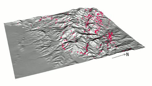
| This map shows landslide locations and shapes for a part of the earthquake-affected area. This inventory of
landslides, digitized from high-resolution aerial photography, is the basis for making a predictive model of future
seismic landslide hazards. |
The areas of greatest landslide concentration occurred in weak, poorly cemented, geologically young rock and soil.
These materials have been rapidly uplifted through the eons by events like the Northridge earthquake, and because
of their weakness are rapidly eroded by rainfall, earthquake shaking, and other processes. The balance of rapid
uplift and erosion in these weak materials has produced steep-walled canyons with high topographic relief, and
slopes that fail readily during earthquakes and rainstorms.
The most common types of landslides were shallow rock falls and rock slides, numbering in the thousands, and up
to tens of thousands if very small failures are counted. These landslides were highly disrupted, chaotic jumbles
of soil, rock, and vegetal debris. In some areas, more than 75 percent of slope areas were denuded by landslides.
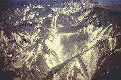
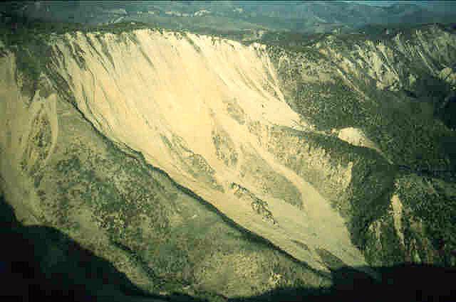
| The light-colored areas in this photograph are slopes laid bare by landslides in the Santa Susana Mountains
caused by the earthquake. |

These failures ranged in volume from a fraction of a cubic meter to a few hundred thousand cubic meters. Some of
the larger slides traveled several hundred meters from their sources. In some cases, landslide debris completely
filled canyon bottoms, or traveled as far as 200 meters onto flatter areas beyond the bases of slopes. The debris
in canyon bottoms poses a secondary threat because it can be mobilized during rainstorms to form debris flows.
Such flows are common, problematical, and often disastrous throughout southern California, and their potential
may now be enhanced in the earthquake-affected areas.
Deeper, more coherent landslides called slumps and block slides numbered in the tens to hundreds, and occurred
primarily in the Santa Susana and Santa Monica Mountains. Although these were far less numerous than the shallow
slides and falls, they contributed significantly to the total volume of landslide material because they tended
to be much larger. A few of these features had volumes of several million cubic meters. Most of these occurred
along a single ridge between Piru and Castaic Junction where a weak clay formation is exposed in the mountains.
Landslide damage to buildings, roads, pipelines, and other structures was not as severe as it might have been in
a more extensively developed area. However, landslides blocked many roads in the Santa Susana and western San Gabriel
Mountains, hampering relief efforts and exacerbating the overall transportation problems caused by the earthquake.
Landslides did extensive damage to roads, pipelines, and well machinery in oil fields in the Santa Susana Mountains.
Dozens of homes in the central and eastern Santa Monica Mountains were moderately or severely damaged by movements
of large block slides.
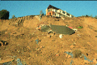
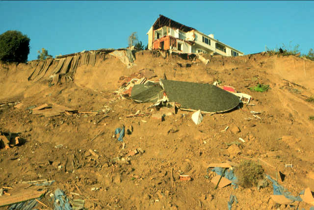
| This home in Pacific Palisades near Santa Monica was damaged when the coastal bluff on which it was built failed
during the earthquake. The landslide caused half the house to be torn loose and cascade down the steep slope. |
Landslide Susceptibility -- Where do Future Dangers Lie?
USGS scientists are using various properties of slopes and earthquake
shaking to forecast the stability of slopes during future earthquakes in the region. The forecast is in the form
of a susceptibility map of the Los Angeles 1:100,000 topographic map quadrangle. An example of a part of the susceptibility
map shown here indicates 6 degrees of stability of slopes during earthquakes, ranging from extremely stable to
unstable. Principal characteristics of the map are its great detail and its digital format. Additionally, the map
was constructed in collaboration with county geologists, the California Division of Mines and Geology (CDMG), private
consulting firms who are the people and entities most likely to need and use it in the future.
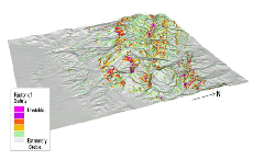
| This is a forecast of the stability of slopes during earthquake shaking in a mountainous area north of Los Angeles.
This map can be used with earthquake-shaking information to produce a variety of scenarios of slope failures during
postulated earthquakes of different magnitudes and locations. The map can be used for planning development in sloping
areas, emergency-preparedness planning, and predicting lifeline disruptions in future earthquakes. |
The susceptibility map is constructed using data for each 10-meter-square cell in the area covered by the map.
These data include slope steepness and measures of the strength of geologic materials. The data are necessary inputs
to a mathematical slope-stability model that yields a single numerical value for each cell. This value is called
the critical acceleration, which is a measure of the level of earthquake shaking that must be exceeded to cause
the slope in that cell to fail. The numerical values of critical acceleration can be grouped into colors for displays
like the map sample shown on this page. Scientists can test and adjust the susceptibility map using the landslide
inventory data derived from the Northridge earthquake.
|

Lessons Learned
The Northridge earthquake provided an unprecedented amount of high-quality
data useful for analyzing instabilities in earth slopes subjected to seismic shaking. The highly detailed landslide
inventories and hundreds of strong-motion records of variations in earthquake shaking allowed scientists to examine
landsliding in great detail. These data, combined with high-resolution topographic and geologic data, resulted
in the susceptibility mapa forecasting tool of exceptional quality and flexibility.
Scientists also learned, in the case of the valley fever outbreak, that earthquakes typically provide surprises
beyond the realm of efforts to forecast hazards.
|
Valley Fever
A major outbreak of "valley
fever" occurred in Ventura County in the weeks following the Northridge earthquake. In just 8 weeks, more
than 200 valley fever cases were diagnosed, which is 16 times the normal infection rate. The cases were heavily
concentrated in the Simi Valley rather than in the San Fernando Valley where the earthquake was centered. Both
the timing and location of the valley fever cases suggests that the outbreak was caused by dust generated by landslides
caused by the earthquake. Canyons in the Santa Susana Mountains, northeast of the densest cluster of valley fever
cases, produced many dust-generating landslides during the shaking. Prevailing winds during and after the earthquake
blew from the northeast to the southwest, and carried the dust from the canyons into Simi Valley and beyond. The
valley fever outbreak led to hospitalization of more than 50 people and ultimately to three fatalities.
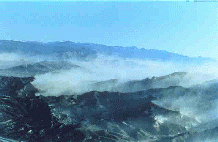
| Dust from landsliding blows out of the Santa Susana Mountains into the Simi Valley where an outbreak of valley
fever occurred following the earthquake. |