Debris flows in Grand Canyon are initiated by a combination of intense precipitation and subsequent slope failure. The intensity of rainfall necessary to initiate debris flows in Grand Canyon is poorly known because few climatic stations are in debris-flow producing tributaries. Previous studies have reported rainfall that initiates debris flows to have intensities greater than 25 mm/hr with a total rainfall of at least 16 to 50 mm (Webb and others, 1989; Melis and others, 1994). The recurrence interval of precipitation on the days when debris flows have occurred in Grand Canyon ranges from less than one year to more than sixty years (table 2). Multiday storms that precede debris flows had larger recurrence intervals, typically greater than 100 years.
Intense precipitation may occur in summer or winter throughout Grand Canyon. Three types of storms can cause floods in the southwestern United States: localized or widespread convective thunderstorms in summer, regional frontal systems in winter, and dissipating tropical cyclones in late summer and early fall (Hansen and Shwarz, 1981; Hirschboeck, 1985; Webb and Betancourt, 1992; Thomas and others, 1994). Most historic debris flows in Grand Canyon are associated with the intense precipitation of convective summer thunderstorms that affect only one or two drainages at a time. These storms are fed by large quantities of moisture, evaporated from the northern Pacific and Gulf of California by monsoonal circulation patterns. Debris flows also occur during prolonged precipitation produced in winter by regional frontal systems (Cooley and others, 1977). These widespread storms sweep across the Colorado Plateau from the west along the Pacific storm track, which is shifted south during the winter by the Aleutian Low in the North Pacific Ocean (Webb and Betancourt, 1992). Rain that can be both widespread and intense is produced by occasional dissipating tropical cyclones in the late summer and early fall (Smith, 1986), but these storms have only caused debris flows in Prospect Canyon (Melis and others, 1994; Webb and others, 1996).
| Table3. Precipitation associated with selected debris flow in Grand Canyon. | ||||||||
|
|
||||||||
| Tributary | River mile- side |
Basin area (km2) |
Date of debris flow |
Nearest climate station |
Daily precip- itation (mm) |
Recurr- ence interval (years) |
Storm1 precip- itation (mm) |
Recurr- ence interval (years) |
|---|---|---|---|---|---|---|---|---|
|
|
||||||||
| Badger Canyon | 7.9-R | 47.0 | 8/18/94 | Lees Ferry | 45 | 46 | 45 | 16 |
| 18-Mile Wash | 18.0-L | 5.1 | 8/24/87 | Desert View | 14 | <1 | 17 | <1 |
| Unnamed | 19.9-L | 3.8 | 8/24/87 | Desert View | 14 | <1 | 17 | <1 |
| Unnamed 62.5-R | 0.7 | 9/18/90 | Desert View | 19 | <1 | 61 | 34 | |
| Crash Canyon | 62.6-R | 1.8 | 9/18/90 | Desert View | 19 | <1 | 61 | 34 |
| Unnamed | 63.4-R | 0.7 | 9/18/90 | Desert View | 19 | <1 | 61 | 34 |
| Lava Canyon | 65.5-L | 54.7 | 12/5/66 | Grand Canyon | 43 | 16 | 118 | 157 |
| Tanner Canyon | 68.5-L | 19.3 | 8/22/93 | Desert View | 28 | 3 | 56 | 8 |
| Cardenas Creek | 70.9-L | 3.9 | 8/22/93 | Desert View | 28 | 3 | 56 | 8 |
| Unnamed | 71.2-R | 1.1 | 8/21/84 | Grand Canyon | 35 | 3.2 | 69 | 7.6 |
| Unnamed | 72.1-R | 1.2 | 8/21/84 | Grand Canyon | 35 | 3.2 | 69 | 7.6 |
| 75-Mile Creek | 75.5-L | 11.5 | 8/24/87 | Desert View | 14 | <1 | 16 | <1 |
| 9/18/90 | Desert View | 19 | <1 | 61 | 34 | |||
| Monument Creek | 93.5-L | 9.7 | 7/27/84 | Grand Canyon | 27 | 1 | 39 | 1 |
| Hermit Creek | 95.0-L | 32.0 | 7/15/96 | Grand Canyon | ||||
| Crystal Creek | 98.2R | 111.6 | 12/6/66 | Tuweep | 96 | 63 | 157 | 63 |
| Forster Canyon | 122.7-L | 10.0 | 9/8/91 | Grand Canyon | 13 | <1 | 18 | 1.9 |
| Fossil Canyon | 125.0-L | 34.4 | 8/19/89 | Grand Canyon | 46 | 8 | 92 | 25 |
| Unnamed | 126.9-L | 0.6 | 8/19/89 | Grand Canyon | 46 | 8 | 92 | 25 |
| Unnamed | 127.3-L | 0.8 | 8/19/89 | Grand Canyon | 46 | 8 | 92 | 25 |
| Unnamed | 127.6-L | 1.8 | 8/19/89 | Grand Canyon | 46 | 8 | 92 | 25 |
| Bedrock Canyon | 130.5-R | 21.1 | 8/19/89 | Grand Canyon | 46 | 8 | 92 | 25 |
| Unnamed | 157.6-R | 11.1 | 8/6/93 | Peach Springs | 20 | <1 | 22 | <1 |
| Unnamed | 160.8-R | 3.4 | 8/6/93 | Peach Springs | 20 | <1 | 22 | <1 |
| Prospect Canyon | 179.4-L | 257.2 | 9/6/39 | Grand Canyon | 32 | 7 | 98 | 158 |
| 7/24/54 | Grand Canyon | 27 | 1 | 27 | --2 | |||
| 7/24/55 | Mount Trumbull | 111 | 100 | 112 | 100 | |||
| 9/17/63 | Mount Trumbull | 23 | <1 | 23 | <1 | |||
| 3/5/95 | Tuweep | 43 | 5 | --2 | --2 | |||
| Unnamed | 207.8-L | 3.1 | 9/23/91 | Peach Springs | 35 | 3 | --2 | --2 |
| Diamond Creek | 225.8-L | 716.7 | 7/20/84 | Tuweep | 53 | 10 | 90 | 24 |
|
|
||||||||
| 1Storm is defined as consecutive
days with measurable rainfall. 2 One day storm. |
||||||||
In general, moisture and storm systems travel across Grand Canyon from west to east and south to north. Strong orographic lifting occurs in the vicinity of the Kaibab Plateau, with greater rainfall falling at higher elevations (table 1). It should be noted that, although intense or prolonged rainfall is necessary for the occurrence of a debris flow, rainfall alone is not a sufficient cause because a slope failure is also required (Melis and others,1994). The occurrence of debris flows cannot be predicted solely on the basis of rainfall.
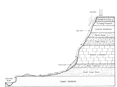
Debris-flow source sediments in Grand Canyon consist of weathered and jointed bedrock, colluvial wedges, or sediment stored in or adjacent to channels. Numerous exposed Paleozoic and Proterozoic strata, ranging from shale to sandstones and limestones, provide many types of source rock in a setting of high topographic relief (figs. 3, 8). Weathering and erosion are constantly at work on these strata as the canyon continues to widen (Ford and others, 1974; Webb and others, 1989; Hereford and Huntoon, 1990; Melis and others, 1994). Elevational and temperature gradients, along with a high degree of annual and inter-annual climatic variability, promote rock expansion/contraction as well as precipitation-related infiltration and frost action. All Grand Canyon drainage basins, particularly the largest ones, are influenced to some extent by regional and localized faults, folds and joints, which weaken bedrock to various degrees. Soft shale units erode quickly, and can destabilize overlying cliffs of more indurated sandstones and limestones. These processes result in rockfalls and rock avalanches that occur in all seasons, and under a wide variety of weather conditions, but are especially common during the winter due to prolonged precipitation and freezing temperatures. Larger slab failures also occur in the more indurated sandstones, especially the Coconino and Esplanade Sandstones, as compressive stresses are released during erosive unloading.
|
| Figure 8. Debris-flow source areas exposed in Monument Creek (river mile 93.5-L), Grand Canyon, Arizona. The Supai Group forms the dark, ledgy unit in the middle of the section; the overlying slope is Hermit Shale. The 1984 debris flow was initiated in the Hermit Shale and the lowest member of the Supai Group (Webb and others, 1988). |
Rockfalls and slab failures do not necessarily produce debris flows, but they do produce large amounts of colluvium that is an important source material for debris flows. This colluvium collects where softer units have eroded to form benches, particularly the Hermit Shale and the distinctive Tonto Platform formed by the Muav Limestone and Bright Angel Shale (figs. 1, 3). Various shale units within the members of the Supai Group form smaller, high-angle slopes that also collect loose debris (fig. 8).
Other sources of loose, poorly sorted debris are shear zones in the many fault-controlled drainages present in Grand Canyon, such as 75-Mile Canyon (river mile 75.5-L). This tributary has formed along the strike of east-trending 75-Mile Fault, and drainages have formed preferentially along the highly fractured, footwall-side of the fault. Since 1959, three debris flows have been initiated exclusively in colluvium accumulated in these footwall sub-basins (Melis and others, 1994). Alluvial deposits, especially old debris-flow levees along the sides of tributary channels, also provide source sediments. Once initiated, debris flows in Grand Canyon often “bulk up”, entraining sediments from terrace deposits and gaining volume and velocity as they head toward the river (Melis and Webb, 1993; Melis and others, 1994; Webb and others, 1996).
Melis and others (1994) identified four main mechanisms of debris-flow initiation in Grand Canyon: 1) the failure of weathered bedrock; 2) the “firehose effect” of runoff falling onto unconsolidated colluvial wedges, 3) direct failure of colluvial wedges, 4) combinations of the first three mechanisms (fig. 9). We extend the data from Melis and others by adding information from debris flows that occurred between 1994 and 1996. The largest debris flows — which are few in number — begin with the failure of weathered Paleozoic shales and sandstones, most often in either the Hermit Shale or Supai Group, although failures also occur in other formations such as the Bright Angel Shale (fig. 10). Bedrock failures are most often triggered by intense, localized rainfall from convective summer thunderstorms, although bedrock failures occurred in the December 1966 debris flow (Cooley and others, 1977). One example of this failure mechanism occurred during the Monument Creek (river mile 93.5-L) debris flow of 1984 (Webb and others, 1988,1989). On July 25, runoff from a thunderstorm centered over the eastern part of Monument Creek caused a slope failure in the Esplanade Sandstone. The failure became an avalanche that fell 650 m and mobilized into a debris flow upon reaching the creek channel. The debris flow traveled 4.5 km to the Colorado River where deposition of boulders significantly altered flow in Granite Rapid (Webb and others, 1988).
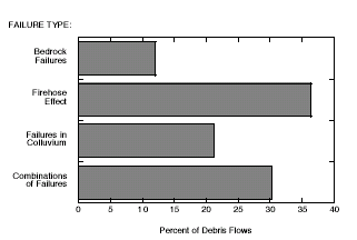 |
| Figure 9. Failure mechanisms that have initiated debris flows in Grand Canyon from 1939 through 1996 (modified from Melis and others, 1994). |
 |
| Figure 10. Schematic diagram illustrating the initiation of debris flows by the failure of bedrock - usually the Hermit Shale and Supai Group - during intense rainfall. |
Most debris flows in Grand Canyon are produced by the “firehose effect.” In this mechanism, runoff pours over a cliff face and impacts colluvium at the base of the cliff, causing bulk failure (Johnson and Rodine, 1984). This process frequently occurs in drainages that have high-elevation catchments, leading to waterfalls over the Redwall Limestone, with runoff falling on colluvium that overlies slopes of Muav Limestone and Bright Angel Shale (figs. 11, 12). As with bedrock failures, the firehose effect is usually triggered by small summer thunderstorms but can also occur during less-intense regional storms, especially in large tributaries that concentrate runoff at a single pourover. The firehose effect triggered a debris flow in “Crash Canyon” (river mile 62.6-R) on or about September 18, 1990 (Melis and Webb, 1993). Runoff from convective thunderstorms poured over the Redwall Limestone cliffs of Chuar Butte, falling onto massive colluvial deposits overlying Muav Limestone. The colluvium failed, resulting in a debris flow (Melis and others, 1994).
 |
| Figure 11. Failure scars caused by the “firehose effect” on colluvial wedges overlying Muav Limestone at river mile 62.5-R, Grand Canyon, Arizona (photograph is by T.S. Melis). |
 |
| Figure 12. Schematic diagram illustrating the initiation of debris flow by colluvial wedge failure during intense rainfall. |
Failures of colluvial wedges occur during either intense or prolonged rainfall, and usually result in smaller debris flows. In the case of low-intensity, sustained rainfall, saturation may be hastened by concentrated sheetflow runoff from cliff faces. This substantial runoff is focused at the intersection of colluvial wedge and cliff face, augmenting direct precipitation and increasing the rate of saturation. The probability of slope failure is enhanced by the low density of vegetation on talus slopes in Grand Canyon. Multiple source areas combined with the extreme topographic relief of Grand Canyon can result in combinations of the three basic initiation mechanisms.
Shales are a critical factor in the initiation of debris flows in the Colorado River drainage basin. Weathered shale bedrock fails readily, either producing debris flows directly or contributing source material to colluvial wedges. Shales form the slopes in Grand Canyon and store unconsolidated source material. If colluvial wedges do not fail, the underlying bedrock may fail, mobilizing the overlying colluvium. Eroding shales also undercut more-indurated, cliff-forming lithologies, contributing to their failure. Of most importance, shales in Grand Canyon provide abundant fine particles and clay minerals that are essential to the mobility and transport competence of debris flows, giving them the internal strength necessary to transport large boulders over long distances. Electrochemical attraction among clay particles increases debris-flow matrix strength, and strong water absorption helps maintain high pore pressures, one condition deemed necessary to support large clasts (Hampton, 1975; Pierson and Costa, 1987; Major and Pierson, 1992). Most Grand Canyon debris flow deposits contain 1-8 percent silt- and clay-size particles by weight (fig. 13); the exception is Prospect Canyon, which has a unique setting for debris-flow initiation (Webb and others, 1996). These fine particles occupy interstitial spaces in debris-flow slurries, increasing the density of the matrix and the buoyant forces that contribute to the suspension of larger particles (Beverage and Culbertson, 1964; Hampton, 1975; Rodine and Johnson, 1976). Fine-grained constituents of these debris flows are 60-80 percent illite and kaolinite by weight, reflecting the terrestrial source shales and colluvial wedges (table 4).
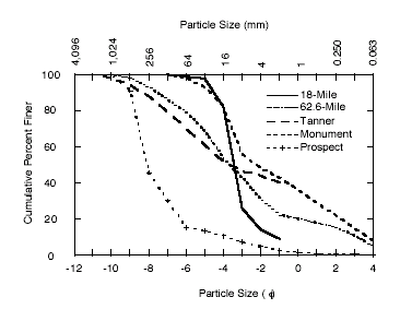 |
| Figure 13. Particle size distribution of selected debris flows in Grand Canyon (Webb and others, 1989; Melis and others, 1994). 18-Mile, the 1987 debris flow at 18-Mile Wash; 62.6-Mile, the 1990 debris flow at “Crash Canyon,” mile 62.6-R; Tanner, the 1993 debris flow at Tanner Canyon; Monument, the 1984 debris flow in Monument Creek; and Prospect, the 1995 debris flow in Prospect Canyon. |
| Table 4. Clay mineralogy of source material and debris flow in Grand Canyon1 | |||||
|
|
|||||
| Sample Type | Location (mile-side) |
Illite1 (weight %) |
Kalinite1 (weight %) |
Smectite1 (weight %) |
Other1 (weight %) |
|---|---|---|---|---|---|
|
|
|||||
| Hermit Shale | 7.9-L | 54 | 41 | 0 | 5 |
| Esplanade Sandstone | |||||
| - basal unit | 20.5-R | 50 | 40 | 2 | 8 |
| Bright Angel Shale | 58.0-L | 68 | 22 | 0 | 10 |
| Colluvium | 24.4-L | 29 | 62 | 0 | 9 |
| Colluvium | 58.0-L | 20 | 68 | 0 | 12 |
| Colluvium | 62.2-R | 32 | 35 | 7 | 26 |
| Colluvium | 62.5-R | 43 | 40 | 8 | 9 |
| Colluvium | 62.6-R | 22 | 49 | 2 | 27 |
| Debris-flow deposit | 62.6-R | 58 | 24 | 0 | 18 |
| Colluvium | 63.3-R | 49 | 23 | 10 | 18 |
| Colluvium | 67.2-L | 10 | 82 | 0 | 8 |
| Colluvium | 68.5-L | 22 | 57 | 0 | 21 |
| Debris-flow deposit | 71.2-R | 19 | 31 | 0 | 50 |
| Debris-flow deposit | 72.0-R | 48 | 30 | 0 | 22 |
| Debris-flow deposit | 75.5-L | 62 | 17 | 0 | 21 |
| Debris-flow deposit | 98.2-R | 42 | 38 | 0 | 20 |
| Debris-flow deposit | 126.9-L | 43 | 43 | 2 | 12 |
| Colluvium | 127.3-L | 44 | 25 | 17 | 14 |
| Debris-flow deposit | 127.5-L | 38 | 38 | 0 | 24 |
| Colluvium | 127.6-L | 45 | 29 | 6 | 20 |
| Colluvium | 179.4-L | 35 | 29 | 6 | 30 |
| Debris-flow deposit | 179.4-L | 34 | 38 | 4 | 24 |
| Debris-flow deposit | 205.5-L | 56 | 15 | 8 | 21 |
| Debris-flow deposit | 224.5-L | 60 | 15 | 6 | 19 |
|
|
|||||
| 1Minerals identified by semi-quantitative x-ray diffraction. Margin of area ± 20% (Starkey and others, 1984). | |||||
Three lithologic units dominate the initiation sites for debris flows in Grand Canyon. The Hermit Shale is the most important unit of the three source areas in terms of generating debris flows. This shale is prone to both bedrock and colluvial failures, and undermines the overlying Coconino Sandstone, a source of many large boulders in eastern Grand Canyon, as it erodes. Where the Hermit Shale is first elevated to heights over 100 m above the Colorado River (about river mile 20.0), a set of some of the most closely-spaced rapids in Grand Canyon, informally termed “the Roaring Twenties,” begins (fig. 1). Although the lithology and structure of the canyon have not changed significantly at this point, the elevation of the Hermit shale beyond a threshold height above the river gives failures sufficient potential energy to transform into debris flows. Beyond this stretch of river, the Hermit Shale remains a key factor in debris-flow initiation, but may be too high on the cliffs to occur in the smaller drainages. In smaller tributaries without exposures of Hermit Shale, the lower units of the Supai Group or colluvial wedges of the Tonto platform become more important in generating debris flows. Terrestrial shales in the Supai Group — particularly the basal unit of the Esplanade Sandstone — are also major sources of bedrock failures, providing both fine particles and large boulders from interstratified shale and sandstone units. Many failures occur in the Esplanade Sandstone, which is undercut by erosion of the basal shale unit. The Muav Limestone contains thin, interbedded shales and grades into the underlying marine Bright Angel Shale. The erosional shelf formed by these units is the Tonto Platform, a broad shelf at the base of the Redwall Limestone that stores abundant colluvial material throughout Grand Canyon downstream from river mile 60 (fig. 1).
From the time of the first exploration of Grand Canyon by John Wesley Powell in 1869, the occurrence of rapids in Grand Canyon has been linked to the presence of resistant bedrock at river level (Powell, 1875). The large boulders that form rapids are well-indurated and derive from resistant bedrock units, but they have been rafted down to the river from tributary side canyons, often over many kilometers, by debris flows. The initiation of these debris flows is dependent on the presence of exposed shale units as both points of initiation and sources of fine materials. Debris flows in Grand Canyon, and ultimately the rapids they form, depend on the presence of shale source units exposed at greater than 100 m above the Colorado River. Without the combination of exposed shale units at height and boulder-producing sandstones and limestones, debris flows that form rapids will rarely occur.
Next: Logistic-Regression Analyses
| AccessibilityFOIAPrivacyPolicies and Notices | |
 |
|