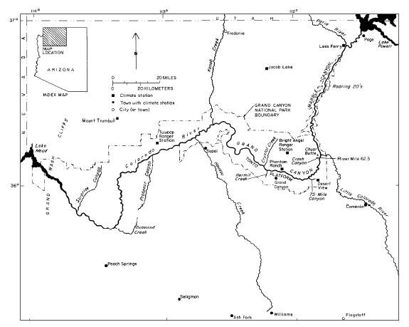
Debris flows are the primary sediment transport process in 600 tributaries of the Colorado River between Lees Ferry and Diamond Creek, Arizona (fig. 1). This type of flash flood contains up to 80 percent sediment by weight and deposits poorly sorted sediment that ranges from fine clays to extremely large boulders (b-axis >3 m) in the river (Melis and others, 1994). All but the largest boulders were entrained by typical, pre-dam Colorado River floods, and debris fans, which are composed of residual boulders, form rapids in the Colorado River (fig. 2). Because debris fans raise the bed elevation (Howard and Dolan, 1981), the Colorado River forms large pools upstream from rapids. Flow through rapids ends in pools (Dolan and others, 1978; Kieffer, 1985), the downstream end of which is controlled by bedrock outcrops or alternating debris bars that are outwash from the upstream debris fan (Howard and Dolan, 1981; Webb and others, 1989; Melis and Webb, 1993; Melis and others, 1994). Half of the vertical drop of the Colorado River occurs in rapids, which account for only 10 percent of the river’s length through Grand Canyon (Leopold, 1969). By forming rapids, debris flows define the longitudinal profile and control the geomorphic framework of the Colorado River in Grand Canyon (Webb, 1996).
|
| Figure 1. The Colorado River in Grand Canyon, Arizona |
|
(Modified from Hamblin and Rigby, 1968) Explanation
|
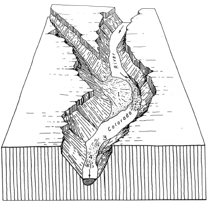
| Figure 2. The morphology of a typical debris fan and rapid on the Colorado River in Grand Canyon. |
A better understanding of the factors and processes involved in the initiation of debris flows is critical to understanding the dynamic processes that shape and control the Colorado River in Grand Canyon National Park. Moreover, debris flows are a significant geomorphic hazard worldwide (Costa and Wieczorek, 1987). The debris-flow process is of interest not only to scientists but also to the more than 20,000 whitewater enthusiasts that run the rapids in Grand Canyon every summer (Stevens, 1990). An average-sized debris flow can alter the severity of a major rapid or riffle, or cover a popular camping beach with boulder-strewn debris in a matter of seconds. Because of operation of Glen Canyon Dam, rapids constricted by debris flows are only partially reworked by flow in the regulated Colorado River (Graf, 1980; Melis and Webb, 1993; Webb and others, 1996).
Most of Grand Canyon is unaffected by humans and provides an excellent setting for studying debris-flow processes that are little influenced by land-use practices. Also, the scenic beauty of Grand Canyon has generated an enormous body of photographs of the Colorado River beginning in 1872 (Melis and others, 1994). These photographs contain a wealth of information on the occurrence of debris flows over the last century (Webb, 1996), and provide us with binomial-frequency data: whether or not a debris flow has occurred in the last century.
This study examines the process of debris-flow initiation and transport in Grand Canyon and presents field observations on the roles of climate, canyon lithology, geologic structure, and drainage- basin morphometrics. Particular emphasis is given to the roles of intense precipitation and source areas. We evaluated the relative importance of different types of independent drainage-basin variables in generating debris flows using logistic regression (Hosmer and Lemeshow, 1989). Logistic-regression modeling permits the identification of statistically significant drainage- basin variables, isolating those geomorphic factors that most strongly control debris-flow initiation in the near-vertical cliffs of Grand Canyon and transport to the Colorado River.
The occurrence of debris flows in the last century was determined for 164 tributaries (the “calibration set”) using repeat photography and analysis of hundreds of historical photographs taken of the river corridor from 1872 through 1995. Frequency information for 50 additional tributaries (the “verification set”) was used to test the robustness of the logistic-regression model. Whether or not a debris flow occurred in that period was determined by analyzing the differences between historical photographs and the modern matches. We increased the available data (Melis and others, 1994) from 529 to 600 tributaries of the Colorado River by adding tributaries downstream from Diamond Creek for which frequency information is available. Using the model coefficients obtained from the calibration set, we estimated the probability of debris-flow occurrence for all 600 tributaries.
This study provides an analysis of initiation mechanisms and frequency of historic debris flows in Grand Canyon National Park and vicinity, Arizona. The data presented here will be used as the basis for development of sediment-yield estimates from ungaged tributaries of the Colorado River, a critical element of long-term management of resources downstream from Glen Canyon Dam (U.S. Department of Interior, 1995). This report incorporates existing information on debris-flow frequency in Grand Canyon (Cooley and others, 1977; Webb and others, 1989; Melis and others,1994), and includes 600 tributaries of the Colorado River between Lees Ferry and Surprise Canyon, Arizona (river miles 0 to 248), excluding the Paria and Little Colorado Rivers and Kanab and Havasu Creeks. Repeat photography from the 1889-1890 Stanton expedition (Webb, 1996) provides uniform data for estimation of the binomial frequency of debris flows in 164 tributaries in Grand Canyon. Logistic regression is used to develop a statistical model based on measured morphometric, lithologic, and climatic variables from these 164 tributaries for estimation of the probability of debris-flow occurrence in all 600 geomorphically significant tributaries. This work was funded in cooperation with the Glen Canyon Environmental Studies Program of the Bureau of Reclamation.
In this report, we use the inch-pound unit of mile to describe location of tributaries along the Colorado River; metric units are used for all other measures. Use of river mile has considerable historical precedent (Stevens, 1990) and provides a reproducible method of describing the location of tributaries with respect to the Colorado River. The location of tributaries was described using river miles downstream from Lees Ferry and a descriptor of “L” for river-left and “R” for river-right. The left and right sides of the Colorado River are determined as one faces downstream.
We typically refer to “Grand Canyon” in broad reference to both Marble and Grand Canyons. “Marble Canyon” is the canyon reach of the Colorado River between Lees Ferry and the juncture with the Little Colorado River (river miles 0 to 61.5; fig. 1); we refer to Marble Canyon only for specific tributaries in that reach. Grand Canyon, which is formally designated between the juncture with the Little Colorado River and the Grand Wash Cliffs (river miles 61.5 to about 280), is considerably larger and better known than Marble Canyon. For geological and statistical reasons described in the text, we divide Grand Canyon into eastern Grand Canyon, between Lees Ferry and Crystal Rapid (river miles 0 to 98) and western Grand Canyon, between Crystal Rapid and Surprise Canyon (river miles 98 to 248; fig. 1).
The authors thank the many individuals who helped with the field and office work that made this report possible. We especially thank Dave Wegner of the Glen Canyon Environmental Studies Program, Bureau of Reclamation, for his support of our project. The professionalism of the numerous guides who piloted boats for us on the Colorado River made field work efficient, safe, and fun. Thanks also to all the people who helped with the large amount of repeat photography this study required, particularly Jim Hasbargen. Dominic Oldershaw, Dave Ring, and Sara Light-Waller performed much of the darkroom work. Chuck Sternberg drafted the illustrations. Ed Holroyd, U.S. Bureau of Reclamation in Denver, Colorado, gave extensive technical help and advice with the GIS software. Steve Sutley, of the U.S. Geological Survey in Denver, Colorado, performed all x-ray diffraction analysis. Betsy Pierson, U.S. Geological Survey, provided invaluable statistical support. We also thank Vic Baker, Jim Bennett, Yehouda Enzel, Dick Iverson, Connie McCabe, Waite Osterkamp, Tom Pierson, Steve Reneau, and Kevin Scott for their review of research design and field work in April 1991. Special thanks to Vic Baker and Jay Quade, University of Arizona, for their guidance and critical appraisal, and to Vicky Meretsky and Lauren Hammack for their critical reviews of the manuscript.
| AccessibilityFOIAPrivacyPolicies and Notices | |
 |
|