
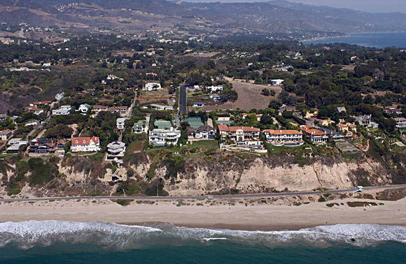
Heavily urbanized bluffs above Zuma Beach just northwest of Point Dume, California. Structures along beach are susceptible to liquifaction during earthquakes while homes on surrounding uplands may sustain damage due to landslides. Aerial photograph courtesy of Kenneth & Gabrielle Adelman, California Coastal Project.
Significant areas on either side of the Ventura-Los Angeles county line could be susceptible to landslides or liquefaction in the event of a strong earthquake. The communities affected include Oxnard, Camarillo, Thousand Oaks, Malibu and Westlake Village.
During an earthquake magnitude 6.0 or greater, strong shaking causes most of the damage. However, Seismic Hazard Zone maps show areas at risk from ground failure due to landslides or liquefaction triggered by shaking. The dangerous effects of these secondary hazards exist when there are poor soil or rock conditions present in the subsurface.
Liquefaction was a major cause of damage in the Kings Harbor area of Redondo Beach during the Northridge earthquake of 1994. The Northridge earthquake also caused more than 11,000 landslides, some of which; damaged structures or blocked roads.
In the Point Dume quadrangle liquefaction zones occur along the beach areas and into Zuma, Ramirez, and Trancas Canyons. Zones also occur in the upper Triunfo Canyon area at Comell. Landslide zones occur frequently throughout the mountainous areas and on the slopes within three miles of the beach. There are scattered landslide susceptible zones in the developed Malibu and Point Dume areas.
Files available for downloading:
ReadMe File ptdume.txt as an unformatted documentation file describing content and formats of this publication (18 kb).
ReadMe File ptdume.ps as a PostScript file (872 kb).
Geologic map database (spatial and attribute GIS) files:
Download all the geologic database layers and supporting materials in ARC/INFO 7.x ASCII EXPORT format, and all of the documentation files, packaged in a single UNIX tar file, compressed with gzip: - ptdume.tar.gz that includes all the geologic map database layers listed below (22.2 MB download, 91 MB uncompressed).
Download individual database layers in ARC/INFO 7.x ASCII EXPORT format, each layer compressed with gzip:
Geology - pd-geol.e00.gz Faults, contacts and geologic units (704 kb download, 2.7 MB uncompressed).
Structure - pd-strc.e00.gz Attitudes and fold axes (24 kb download, 296 kb uncompressed).
Composite base map - pd-topo.e00.gz Composite quadrangle base map layer in vector format (21 MB download, 86.8 MB uncompressed).
For questions about the scientific content of this report, contact John Tinsley
Download a free copy of Adobe Reader
USGS Information Services
Box 25286 Federal Center
Denver, CO 80225
Telephone: 1-888-ASK-USGS
E-mail: infoservices@usgs.gov
| Help
| PDF help |
| Publications main page
| Western Open-File reports for 1997 |
| Department of the Interior
| U.S. Geological Survey |
| Geologic Division
| Western Earth Surface Processes Team
| Western Region GIS Home Page |
| Privacy Statement
| Disclaimer
| Accessibility |
The URL for this page is:
https://pubs.usgs.gov/of/1997/of97-276
Please send comments and suggestions, or report problems, to:
Michael Diggles
Updated: August 28, 2007 (bwr, mfd)