U.S. Geological Survey Open-File Report 97–710
The area of study for this report is the southern portion of Santa Clara County that lies within the Monterey 30 by 60 minute quadrangle, consisting of parts of the Watsonville East, Chittenden, San Felipe, Three Sisters, and Mariposa Peak 7.5 minute quadrangles. The study involved combining compilation of previous published and unpublished work in the area with new mapping completed in the first half of 1997.
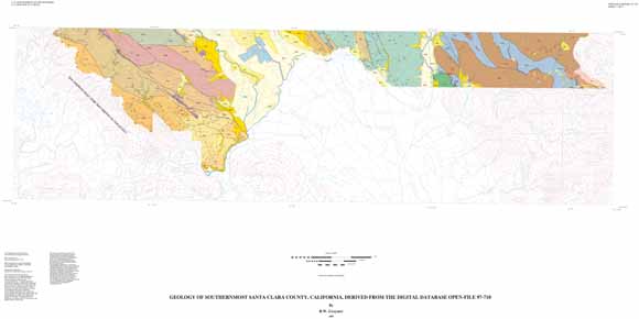
The study area makes up a transect of the central California Coast Ranges, starting just east of the San Andreas fault and continuing east across the Santa Cruz Mountains, the Santa Clara Valley, and into the heart of the Diablo Range. The area includes five fault-bounded structural blocks, each containing a distinct stratigraphic assemblage, and the Santa Clara Valley that contains a large Quaternary alluvial complex overlying and obscuring bedrock relationships. Several active faults, including the Sargent, Castro, and Calaveras faults, as well as others with an unknown amount of recent activity, including the Carnadero, San Jose, and Madrone Springs faults, cut the study area with a general north-northwest trend.
The study area is divided into five fault-bounded structural blocks. Each structural block contains a distinct stratigraphic sequence and has undergone a different geologic history. The differences in stratigraphic sequence are major, and suggest that the rocks in each block formed in different depositional basins, and that large-scale movement on the block-bounding faults has juxtaposed the rocks in each.
The Sierra Azul block in the study area is generally composed of a west-facing, tightly folded and overturned section of Cretaceous and Tertiary strata, unconformably overlain by relatively gently folded Pliocene strata. It is bounded on the west by the San Andreas Fault Zone, and on the east by the Sargent Fault Zone. The strata are disrupted by a west-vergent reverse fault separating Eocene and Miocene strata, probably related to tight folding within the block.
The New Almaden block in the study area is made up of two Franciscan terranes overlain by Miocene and younger strata. Within the map area, the contact between Franciscan and Miocene rocks is everywhere faulted, but north of the area the same Miocene rock unit lies unconformably on Franciscan rocks. The block is bounded on the west by the Sargent Fault and on the east by the San Jose Fault, a postulated fault beneath the surficial deposits of Santa Clara Valley. Because this fault is so poorly located, it is not shown on the geologic map, but the inferred approximate location of the fault is shown on the fault map.
The presence of the same Pliocene unit in both the Sierra Azul and New Almaden blocks, and the presence of detritus in the Pliocene rocks derived from both blocks, demonstrates that the juxtaposition of the two blocks along the Sargent Fault was for the most part complete by the time of Pliocene deposition. However, Pliocene strata are both folded and faulted, so deformation has continued since deposition.
The Silver Creek block in the study area is composed of interbedded Pliocene and younger gravels and volcanic rocks and slivers of serpentinite derived from the Coast Range Ophiolite. It is bounded on the west by the San Jose Fault and on the east by the Calaveras fault. The study area contains only the southern tip of the block, which does not include most of the units found in the block farther north.
The Coyote block is bounded on the west by the Calaveras fault and on the east by the Madrone Springs Fault. The block in the study area is made up of tightly folded and much faulted Late Cretaceous and Paleogene strata, forming an east dipping, west-vergent imbricate stack.
The Mount Hamilton block is composed of two juxtaposed Franciscan terranes, overlain and intruded by Miocene volcanic rocks of the Quien Sabe volcanic field. It is bounded on the west side by the Madrone Springs Fault and on the east by the Tesla-Ortigalita Fault.
The structures in southernmost Santa Clara County with the largest amount of cumulative offset are the block boundary faults. As discussed above, these faults must have undergone large amounts of offset to bring the distinct stratigraphic sequences into juxtaposition. The timing, direction, and amount of offset on most of these faults is poorly understood, but transpressional deformation is suggested by the uplifted terrain, the folded strata, and the structural position of older rocks over younger.
Structural relationships in the study area suggest that the Sargent Fault is an east-dipping, west-vergent reverse fault. Overturning of strata west of the fault in the Sierra Azul block and uplifting of Franciscan terrane rocks east of the fault, as well as observed orientation of one strand of the fault, support this interpretation. This interpretation of the fault agrees with the interpretation of Allen, but conflicts with that of McLaughlin. The west-dipping, east-vergent thrust fault McLaughlin describes probably does form the boundary between the Sierra Azul and New Almaden blocks north of the complicated faults near Mount Madonna, but not in the study area. As mentioned above, the presence of the same Pliocene unit on both sides of the Sargent Fault indicate that most of the offset on the fault was complete by the time of Pliocene deposition. In the area of Sargent Creek, the Pliocene unit is offset by the Sargent Fault, however, indicating about 550 meters of right-lateral apparent offset in Pliocene and/or Quaternary time. The Sargent fault also has evidence of Holocene offset along much of its length, but the section of the Sargent Fault that cuts the Pliocene unit is not considered active. However, a previously unnamed, northwest-trending cross fault between the Sargent and Castro Faults, informally named the Carlyle Hills fault herein, does have evidence of Holocene offset, and this fault also forms the northern boundary of the Pliocene strata that lie on both sides of the Sargent Fault. These relationships suggest that the offset on the active northern part of the Sargent Fault switched from the southern section of the Sargent Fault to the Carlyle Hills Fault soon after Pliocene deposition.
The San Jose Fault is inferred by the juxtaposition of the New Almaden and Silver Creek blocks with different stratigraphic sequences on opposite sides of Santa Clara Valley, and by a pronounced aeromagnetic anomaly. The timing, direction, and amount of offset on this fault, even its exact location, are largely unknown. The offset probably mostly predates the Quaternary deposition of surficial deposits in the Santa Clara Valley, judging from the absence of a pronounced lineament or offset of Quaternary units.
The Calaveras Fault Zone is a major strand of the San Andreas Fault system, having as much as 170 km of Miocene or later right-lateral offset, much of which may have been complete by about 3 to 5 Ma. The Calaveras Fault is also the one active fault in the study area that has generated historic large earthquakes. It has an average short-term right-lateral aseismic slip (creep) rate of 1.2 cm/yr. and geodetic movement of about 1.5 cm/yr. near Hollister, just south of the study area. The zone of active strands of the Calaveras Fault Zone in the study area is more than one kilometer wide, and contains at least ten active strands. The fault trend changes abruptly just north of San Felipe Lake from north 43° west on the northern segment to north 20° west on the southern. Dibblee and Rogers mapped a continuation of the N43W trend to the south as part of the Quien Sabe Fault, but this fault has no expression in the Quaternary deposits in or south of the study area. It is possible the Quien Sabe Fault is an abandoned (pre-Quaternary) part of the Calaveras Fault Zone, or that the Quien Sabe Fault continues to be active, but is poorly expressed in the surficial deposits.
The Madrone Springs Fault is an east-dipping, west vergent reverse fault with an unknown amount of strike-slip offset. Wentworth and others show the Greenville Fault splaying into the Madrone Springs Fault near Gilroy Hot Springs, north of the study area. The Greenville Fault has about 12 km of right-lateral offset based on offset serpentinite bodies in northernmost Santa Clara and southernmost Alameda Counties, an amount of offset that must be accommodated by the Madrone Springs Fault in the area of this report.
In addition to the block bounding faults that are active, there is at least one other active fault in the study area. The Castro Fault, within the New Almaden block, is an active, high angle reverse-right-lateral fault. The orientation of the fault is shown by the relatively straight fault trend, and the juxtaposition of Mesozoic rocks on the east against Quaternary rocks on the west in Castro Valley.
Additional faults have structural or geomorphic features suggesting that they might be active, but they lack documented offset of Holocene strata. The Carnaderos Fault, in the Chittenden quadrangle, forms the eastern front of the Santa Cruz Mountains in the study area. The linear nature of the range front, the continuing uplift of the range, as well as the presence of standing water along the fault near Gavilan College in springtime (sag ponds?) suggest the possibility of continuing activity. Several unnamed fault strands in the northwest part of the Three Sisters quadrangle are marked by remarkably linear valleys and topographic saddles, which could indicate recent activity.
Miocene and older rocks have undergone tight to isoclinal folding in all structural blocks in the area, indicating a major component of compressional deformation in Miocene and younger time. Although the juxtaposition of different strata in different structural blocks makes reconstruction of total compression across the study area impossible, overturned folding within the Sierra Azul block indicates at least 50%, or 4.3 km, of compressional strain normal to the bounding faults in Miocene and younger time. Although the other blocks do not contain Miocene strata in the study area, both the Coyote and Silver Creek blocks have evidence of at least 50% compressional strain normal to the bounding faults in Miocene or younger time north of the study area. Assuming that the same minimum of 50% Miocene and younger compression normal to the bounding faults is present in the other two blocks, the study area has undergone at least 32 km of Miocene or younger fault normal compression without considering any compressional deformation on block bounding faults.
Pliocene rocks of the Sierra Azul and New Almaden blocks have also been folded, but in relatively broad, upright folds, indicating that some of the compression had already taken place by the time of Pliocene deposition. Late Pliocene and early Pleistocene strata in the Silver Creek block in the study area are not folded, but are steeply tilted, probably related to folding truncated by the nearby Calaveras Fault Zone. Pleistocene and Holocene deposits have not been observably folded in the study area, but Pleistocene alluvial fans have been uplifted and remain at a higher level than younger alluvial fans in much of the area, indicating ongoing compression and uplift.
Files available for downloading:
View the database explanation pamphlet as a PDF file sscdb.pdf (60 kB).
View the geologic explanation pamphlet as a PDF file sscgeo.pdf (88 kB).
View the geologic map sheet as a JPEG file sscmap.jpg (228 kB).
View the geologic map sheet as a PDF file sscmap.pdf (980 kB).
View the geologic explanation sheet as a PDF file: sscexpl.pdf (368 kb).
Download the database package in ARC/INFO 7.x uncompressed export format along with supporting materials in a compressed UNIX tar file (see the database explanation pamphlet for details) ssc_g1.tar.gz (2.1 MB download, 6.8 MB uncompressed).
Download three Postscript plottable files containing images of the geologic maps and base maps at a scale of 1:100,000, explanation sheet, and explanatory text in a compressed UNIX tar file (see the database explanation pamphlet for details) sscps.tar.gz (2.8 MB download, 9.8 MB uncompressed).
For additional information:
Contact Information, Western Region Geology and Geophysics Science Center—Menlo Park
U.S. Geological Survey
345 Middlefield Road, MS-973
Menlo Park, CA 94025-3591
http://geomaps.wr.usgs.gov/
Graymer, R.W., 1997, Geology of the southernmost part of Santa Clara County, California; a digital database: U.S. Geological Survey Open-File Report 97–710. (Available at https://pubs.usgs.gov/of/1997/of97-710/.)
Part of this report is presented in Portable Document Format (PDF); the latest version of Adobe Reader or similar software is required to view it. Download the latest version of Adobe Reader, free of charge.
Last modified July 3, 2012
First posted March 11, 2008

![]() U.S. Department of the Interior |
U.S. Geological Survey
U.S. Department of the Interior |
U.S. Geological Survey
URL: http://pubsdata.usgs.gov/pubs/of/1997/of97-710/index.html
Page Contact Information: GS Pubs Web Contact
Page Last Modified: Wednesday, 07-Dec-2016 16:24:43 EST
