|
Lava-Cooling Operations During the 1973 Eruption of Eldfell Volcano, |
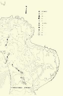
Figure 23.
Map showing movement of the new lavas during a five-week period, from 25 March to 30 April. Movement was determined by ground photogrammetry (tracking fixed markers with a theodelite) or aerial photogrammetry (measuring the movement of fixed markers on successive, stereoscopic vertical aerial photographs). fyrrverandi strönd = former coastline.
Click on figure to zoom in.
 |
|
 |
 |