Map Showing Generalized Thickness Contours of the Pittsburgh Coal Bed in Pennsylvania, West Virginia, and Maryland
Compilation by Susan Tewalt,
Leslie Ruppert, Linda Bragg, Richard Carlton, David Brezinski, and Rachel Wallack;
Digital Compilation by Susan Tewalt, Leslie Ruppert, Rachel Wallack, and Eric
Weiss
U.S. Geological Survey Open-File Report 97-748
Any use of trade, product, and firm names is for descriptive purposes only and does not imply endorsement by the U.S. Government
[ Data | Introduction | Methods | Discussion | Acknowledgments | References ]
 |
[ Legend
| Index Map | Extent | Lithology | Discussion | Figure 2 Map
]
[ Select Different Area ]
The ARC/INFO export files for three Pittsburgh coal bed coverages used in the National Coal Assessment are explained below. C stands for coal, 9 for region 9 of the US energy regions, and 024 was the numeric code assigned by the Appalachian project to the Pittsburgh coal bed. Right-click on links for export files to save the files to disk.
c9024is.e00 export file for isopach map of Pittsburgh main bench [12 MB]
c9024is.mdf metadata file for above coverage
c9024ob.e00 export file for overburden map of Pittsburgh main bench [24 MB]
c9024ob.mdf metadata file for above coverage
c9024st.e00 export file for structure contour (elevation) of Pittsburgh main bench [13 MB]
c9024st.mdf metadata file for above coverage
Export files are in decimal degrees. The isopach map is the coverage used to calculate resources and is not the same coverage used in USGS Open-file report 97-748.
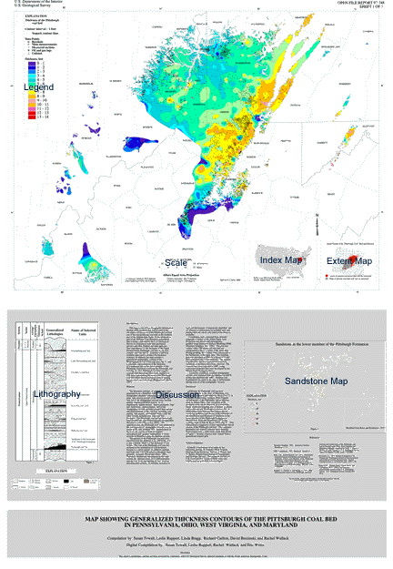
This map is one of four Geographic Information System (GIS) products that will be used in the calculation of resources of the Pittsburgh coal bed, one of the top-producing coal beds in the northern part of the Appalachian basin. It was prepared as part of the National Coal Resource Assessment that is being conducted by the U.S. Geological Survey in cooperation with state geological surveys and other Federal and state agencies. This map depicts (1) the thickness of the Upper Pennsylvanian Pittsburgh coal bed in one foot contour intervals and (2) locations of publicly available data used to produce the thickness contours. In addition, the map includes a generalized stratigraphic column of the Monongahela Group of the map area (fig. 1) and a schematic representation of the thickness of a sandstone unit in the lower member of the Pittsburgh Formation overlying the Pittsburgh coal bed (fig. 2). The Pittsburgh coal bed isopach contours and data points have been clipped to a GIS layer representing the areas of the Pittsburgh coal bed where known resources exist or mining has occurred (see insert map) (Ruppert and others, 1997).
The thickness contours, or isopach lines, were generated from a StratiFact (GRG Corp., 1997) stratigraphic database consisting of 4,553 drill core, mine, and outcrop records of the Pittsburgh coal bed. All of the stratigraphic records were verified against original published sources, or, if unpublished, against drillers' and/or geologists' logs and field notes. Approximately half of the stratigraphic records included detailed descriptions and measurements of the coal bed, including coal, parting, and impure, non-banded (bone) coal; the other records included only total coal bed thickness. The Pittsburgh coal bed has historically been divided into nine megascopically-recognizable divisions or units (Stevenson, 1875). The uppermost unit, the Pittsburgh roof, was identified in the vast majority of stratigraphic records over its extent in PA and northern WV. Identification of the roof unit was based both on original descriptions and graphic examination of cross- sections in StratiFact using the database records.
Thicknesses of the Pittsburgh coal bed were exported from the database as an ASCII file of x, y, and z format, where z is the thickness of coal in feet. The coal in the Pittsburgh roof was not included in the summation of coal thickness because it is rarely mined. In addition, partings and bone coal over 0.38 inches in thickness were generally excluded (Wood and others, 1983). Therefore, thicknesses represented on this map include the inherent errors of (1) differentiation among coal, bone, and parting in core, outcrop, and measured sections, (2) possible inclusion of roof coal thicknesses, if improperly identified, and (3) absence of information on included bone and parting intervals where only total bed thickness is available. Coordinates were converted from latitude/longitude to meters in the Albers Equal Area Projection (see above) and subsequently gridded using Interactive Surface Modeling [ISM] (Dynamic Graphics, Inc., 1991). The grid was created with a 300-meter cell size and was extrapolated to the x, y extent of the input data. During gridding, the z values were constrained to the thicknesses of the input data. The resulting grid was smoothed in ISM (by a factor of 3) and then contoured into 1-foot intervals. The isopach map therefore has been generalized and local variations in thickness have been removed. The contour lines were exported to ARC, using conversion programs that were developed by the Illinois State Geological Survey. Locations of publicly available stratigraphic records were exported from the database in ASCII format and imported into ARC. Symbols (see Explanation) are used on the map to differentiate among sources of the stratigraphic records.
Although the Pittsburgh coal bed does thin immediately to the west of Maryland, it is regionally extensive and relatively thick (5 to 7') in southern Pennsylvania, northern West Virginia including part of the Panhandle, and in adjacent areas in eastern Ohio. One exception in the thickness trend can be observed as a somewhat linear, northwest-trending area of thinner or absent coal in Greene and Washington counties, PA. A relationship exists between this feature and an overlying sandstone unit shown in the schematic of the distribution and thickness of sandstone in the lower member of the Pittsburgh Formation as derived from Roen and Kreimeyer (1973) and working maps of John B. Roen (1977) (fig. 2). This relationship is suggestive of post-depositional fluvial erosion of the Pittsburgh coal bed. The computer-generated coal isopach contours show thinning from erosion over a wider areal extent than shown in figure 2, because contours were created from a generalized isopach grid.
Scientific contributions were made by the following persons: N. Fedorko (West Virginia Geological and Economic Survey); J. Shaulis and V. Skema (Pennsylvania Bureau of Topographic and Geologic Survey). The technical reviews of C.B. Cecil and P.C. Lyons (USGS) were very helpful and are gratefully acknowledged.
Dynamic Graphics, 1991, Interactive Surface Modeling, v. 7.1
GRG Corporation, 1997, StratiFact, version 4.5
Roen, J.B., and Kreimeyer, D.F., 1973, Preliminary map showing the distribution and thickness of sandstone in the Lower Member of the Pittsburgh Formation, southwestern Pennsylvania and northern West Virginia: U.S. Geological Survey Miscellaneous Field Studies Map, MF-529, scale 1:250,000.
Ruppert, L., Tewalt, S., and Bragg, L., 1996, Map showing areal extent of the Pittsburgh coal bed and horizon and mined areas of the Pittsburgh coal bed in Pennsylvania, Ohio, West Virginia, and Maryland, digitally compiled by Tully, J., Pierce., J., Weller, A., and Yarnel, J.: U.S. Geological Survey Open-File Report 96-280, scale 1:425,000.
Stevenson, J.J., 1875, Report of progress in the Greene and Washington district of the bituminous coal fields of western Pennsylvania. Second Geological Survey of Pennsylvania: 1875, p.70.
Wood, G.H., Thomas, M.K., Carter, M.D., and Culbertson, W.C., 1983, Coal resource classification system of the U.S. Geological Survey: U.S. Geological Survey Circular 891, 65 p.
Created by the EERT WWW Staff.
[an error occurred while processing this directive]