Map Showing Structure Contours and Overburden Thickness Isopleths of the Pittsburgh Coal Bed in Pennsylvania, Ohio, West Virginia, and Maryland
U.S. Geological Survey Open-File Report 97-864
Sheet 1 |
Sheet 2 [ Introduction | Methods | References ] |
Any use of trade, product, and firm names is for descriptive purposes only and does not imply endorsement by the U.S. Government
SHEET 1
Compilation by Susan Tewalt, Leslie
Ruppert, Linda Bragg, Richard Carlton, David Brezinski, Jeanette Yarnell, and Rachel
Wallack;
Digital Compilation by Susan Tewalt and Rachel Wallack
 |
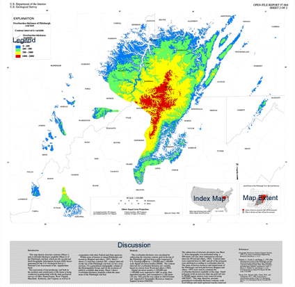
This map depicts the structure contours (Sheet1) and overburden thickness isopleths (Sheet 2) of the Pittsburgh coal bed, which are the second and third Geographic Information System (GIS) layers generated for the U.S. Geological Survey’s National Coal Assessment in the Appalachian Basin.
The assessment of top-producing coal beds in the northern and central parts of the basin is being conducted in partnership with the state geological surveys of Ohio, Pennsylvania, West Virginia, Maryland, Kentucky, and Virginia as well as in cooperation with other Federal and State agencies.
Within areas of known or mined Pittsburgh coal resources (Ruppert and others, 1997), Sheet 1 shows (1) structure contours (50' contour interval) on top of the Pittsburgh coal bed; (2) the locations of publicly available data points; (3) two cross sections; (figs. 1 and 2); and (4) a generalized stratigraphic column of the Monongahela Group (fig. 3). Sheet 2 shows overburden thickness isopleths in these same areas.
The first Appalachian Basin GIS coverage [see inset map shown above (Ruppert and others, 1997)] depicts the areas of known resources and mined areas of the Pittsburgh coal bed and horizon (which are defined as the coal and non-coal equivalents at the base of the Upper Pennsylvanian Monongahela Group). This GIS coverage was used as a clipping polygon in the presentation of the structure, point and overburden thickness isopleth coverages shown on this map. Additional data points (including proprietary data) therefore exist, but are not shown.
Structure contours on the top of the Pittsburgh coal bed were generated from a basin-wide database consisting of 6,993 verified drill core, mine, and outcrop records of the Pittsburgh coal bed. The majority of the stratigraphic data were collected by the State geological surveys and stored in the U.S. Geological Survey’s National Coal Resource Data System (NCRDS). Data were downloaded to StratiFact, a geological database manager (GRG Corp., 1997). The paucity of available stratigraphic data in Fayette and Westmoreland Counties, PA, necessitated obtaining latitude, longitude, and elevation data of random points from published structure contour maps on the base of the Pittsburgh coal bed (Shaulis, 1985; Skema, 1988). In addition, data were digitized at regular intervals from structure contour maps of Wetzel County, WV (Fedorko, 1990 a-k). All of these data were entered into the StratiFact database. The elevation of the Pittsburgh coal bed and horizon was exported from the stratigraphic data base as an ASCII file of x, y and z format, where z is the elevation of the top of the Pittsburgh coal bed (in 2000 points with unavailable bed thickness only the elevation on the bottom of the coal bed was known and was therefore used). Coordinates were converted from latitude/longitude to meters in the Albers Equal Area Projection (see above) and subsequently gridded using Interactive Surface Modeling (Dynamic Graphics, Inc., 1991). The grid was created using a 300-meter cell size and was extrapolated to the x, y extent of the input data. During gridding, the z values were constrained to the elevations of the input data. The resulting grid was contoured into 50-foot intervals and exported to ARC, using conversion programs that were developed by the Illinois State Geological Survey. The point location data were also exported from the database as ASCII files and imported into ARC. Structure contours are color shaded to 400-foot intervals for visual acuity.
Cross section A-A' in Greene County, PA (fig. 1) depicts the Pittsburgh and Sewickley coal beds folded by two anticlines and an intervening syncline. Pittsburgh roof lithologies of coal, coal and shale are evident to the southeast, but disappear in the central part of the section where the Pittsburgh sandstone member overlies the coal. Cross section B-B' (fig. 2) is a regional strike section which uses the base of the Pittsburgh coal bed as a datum. The section shows the inferred original extent (present-day eroded areas are indicated) of the Pittsburgh coal bed, and also a local cutout which is located in Greene County, Pennsylvania.
The authors would like to thank the following: N. Fedorko (West Virginia Geological and Economic Survey), J.R. Shaulis, V.W. Skema, and A.D. Glover (Pennsylvania Bureau of Topographic and Geologic Survey). In addition, the critical reviews of C.B. Cecil and P.C. Lyons (USGS) were very helpful and are gratefully acknowledged.
Data Sources
Dynamic Graphics, Inc., 1991, Interactive Surface Modeling, version 7.1.
Fedorko, Nick, 1990a, Pittsburgh coal structure contours - working map, Paden City quadrangle, WV-OH: West Virginia Geological and Economic Survey Open File Report-014, scale 1:24,000.
________, 1990b, Pittsburgh coal structure contours - working map, Porters Fall quadrangle, WV: West Virginia Geological and Economic Survey Open File Report-014, scale 1: 24,000.
________, 1990c, Pittsburgh coal structure contours - working map, Pine Grove quadrangle, WV: West Virginia Geological and Economic Survey Open File Report-014, scale 1:24,000.
________, 1990d, Pittsburgh coal structure contours, Big Run quadrangle, WV: West Virginia Geological and Economic Survey Open File Report-014, scale 1:24,000.
________, 1990e, Pittsburgh coal structure, contour map, Glover Gap quadrangle, WV: West Virginia Geological and Economic Survey Open File Report-014; scale 1:24,000.
________, 1990f, Pittsburgh coal structure, contour map, New Martinsville quadrangle, WV: West Virginia Geological and Economic Survey Open File Report-014; scale 1:24,000.
________, 1990g, Pittsburgh coal structure, contour map, Wileyville quadrangle, WV: West Virginia Geological and Economic Survey Open File Report-014; scale 1:24,000.
________, 1990h, Pittsburgh coal structure, contour map, Littleton, WV-PA: West Virginia Geological and Economic Survey Open File Report-014; scale 1:24,000.
________, 1990i, Pittsburgh coal structure, contour map, Hundred quadrangle, WV-PA: West Virginia Geological and Economic Survey Open File Report-014; scale 1:24,000.
________, 1990j, Pittsburgh coal structure, contour map - working copy, Center Point quadrangle, WV: West Virginia Geological and Economic Survey Open File Report-014; scale 1:24,000.
________, 1990k, Pittsburgh coal structure, contour map - working copy, Folson quadrangle, WV: West Virginia Geological and Economic Survey Open File Report-014; scale 1:24,000.
GRG Corporation, 1997, StratiFact, version 4.5.
Ruppert, L., Tewalt, S., and Bragg, L., 1997, Map showing areal extent of the Pittsburgh coal bed and horizon and mined areas of the Pittsburgh coal bed in Pennsylvania, Ohio, West Virginia, and Maryland, digitally compiled by Tully, J., Pierce., J., Weller, A., and Yarnel, J.: U.S. Geological Survey Open-File Report 96-280, scale 1:425,000.
Shaulis, J.R., 1985, Coal resources of Fayette County, Pennsylvania, Part 1. Coal crop lines , mined-out areas, and structure contours: Harrisburg, PA, Bureau of Topographic and Geologic Survey, Mineral Resource Report 91, Part 1, p. 10, 34, 66, 79, 88.
Skema, V.W., 1988, Coal resources of Westmoreland County, Pennsylvania, Part 1. Coal crop lines, mined-out areas, and structure contours: Harrisburg, PA, Bureau of Topographic and Geologic Survey, Mineral Resource Report 94, Part 1, p. 20, 44, 48, 57, 77,105.
SHEET 2
Compilation by Susan Tewalt, Leslie
Ruppert, Linda Bragg, Richard Carlton, David Brezinski, Jeanette Yarnell, and
Rachel Wallack;
Digital Compilation by Susan Tewalt and John Tully
|
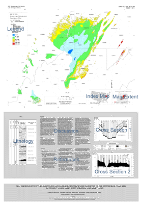
This map depicts structure contours (Sheet 1) and overburden thickness isopleths (Sheet 2) of the Pittsburgh coal bed, which are the second and third Geographic Information System (GIS) layers generated for the U. S. Geological Survey’s National Coal Assessment in the Appalachian basin.
The assessment of top-producing coal beds in the northern and central parts of the basin is being conducted in partnership with the state geological surveys of Ohio, Pennsylvania, West Virginia, Maryland, Kentucky, and Virginia, as well as in cooperation with other Federal and State agencies.
Within areas of known or mined Pittsburgh coal resources (Ruppert and others, 1997), Sheet 1 shows (1) structure contours (50'- contour interval) on the top of the Pittsburgh coal bed; (2) two cross sections; (3) a generalized stratigraphic column of the Monongahela Group; and (4) the locations of publicly available data points. Sheet 2 shows overburden thickness isopleths within the same areas of the Pittsburgh coal bed.
The overburden thickness was calculated by subtracting the structure contour grid on the top of the Pittsburgh coal bed from a grid composed of U.S. Geological Survey 1:250,000 and 1:100,000 scale digital elevation models (DEM). The contour intervals for overburden thickness are variable, based on criteria from Wood and others (1983).
Digital elevation models were imported to ARC as grids, appended together, and resampled to a l00-meter cell size. The grid file was output in ASCII format and imported to Geographic Resources Analysis Support System (GRASS). The subtraction of structure elevations (See Sheet 1) from topography was performed at a 300-meter cell size, then contoured at selected intervals (Wood and others, 1983). Contour lines were exported back to ARC and all of the polygons were attributed according to overburden interval. The areas of known resources and mined areas of the Pittsburgh coal bed and horizon (Ruppert and others, 1997) were used to constrain the overburden isopleths in this map. Small polygons (with an area less than one grid cell size or 90,000 square meters) were removed using ARCEDIT. This map, therefore, presents generalized overburden with local hilltops and small upstream reaches removed.
Geographic Resources Analysis Support System, 1993, U.S. Army Construction Engineering Research Laboratory, v. 4.1.2
Ruppert, L., Tewalt, S., and Bragg, L., 1997, Map showing areal extent of the Pittsburgh coal bed map showing the distribution and thickness in Pennsylvania, Ohio, West Virginia, and Maryland, digitally compiled by Tully, J., Pierce, J., Weller, A., and Yarnell, J.: U.S. Geological Survey Open-File Report 96-280, scale 1:425,000.
Wood, G.H., Thomas, M.K., Carter, M.D., and Culbertson, W.C., 1983, Coal resource classification system of the U.S. Geological Survey: U.S. Geological Survey Circular 891, 65 p.
Created by the EERT WWW Staff.
[an error occurred while processing this directive]