| PREVIOUS |
Of further note is that the scale of these debris flows is very small in comparison with the surface water flows in Capulin Creek itself during and following the rainfall events. Presumably, any debris-flow material that reached the creek would be diluted significantly so as not to impart any significant strength to the flowing water.
Note that most of the movement of materials from the hillslopes mantled by the El Cajete pumice occurred during the first significant rainfall event following the fire; no substantial deepening or widening of rills, or further hillslope erosion was observed during the November visit.
Material weathered from red Gallesteo sandstones and siltstones, however, does appear to be susceptible to more significant debris-flow activity. Colluvium exposed on the west canyon wall 0.5 km south of Base Camp mobilized into a small debris flow sometime during the summer of 1996. This flow occurred in a small tributary to Capulin Canyon, and its location is shown on Figure 3 by the letter B. The deposits of this flow consisted of paired levees approximately 0.3 m high that terminated in an approximately 0.5-m-thick lobe of gravel- and cobble- sized material in a red, clayey matrix.
In addition, material from the lahar and debris-flow deposits of the Cochiti Formation and possibly local areas of non-indurated sandstones and siltstones within the Sante Fe Group appeared to supply material to the very fluid debris flow that was observed near the confluence of the tributary labeled C on Figure 3 with Capulin Canyon. A dark brown mud plaster, not more than 1-cm thick and containing abundant charcoal fragments, was observed on light-colored pumice outcrops lining the channel. The upper mud line could be found approximately 2-m above the channel bottom and a 1.5-m high mud splash line was observed on a tree located on the right channel bank. The debris-flow plaster was not continuous as it had apparently been preferentially washed off smooth rock surfaces by subsequent flood waters. The tributary where this debris flow occurred drains a considerable area off the south flank of Boundary Peak. Presumably, the proportion of material transported from the hillslopes relative to the surface water flow was sufficient to form a very dilute debris flow. No evidence of this debris-flow deposit could be found along Capulin Creek itself, presumably due to dilution by the high flood waters. The adjacent tributary to the south showed only signs of surface water flooding. Note that this debris flow occurred sometime after the June, 1996 visit, as no deposits were observed in the tributary at that time.
In conclusion, while Spittler et al., (1994) identified loose, friable bedrock units and cohesionless soils as factors that contribute to the formation of debris flows, observations made at Bandelier would suggest that these factors resulted in the generation of only minor debris-flow activity. The materials that did appear to be susceptible to debris flow, however, were the colluvium weathered from the sandstones and siltstones of the Gallesteo formation and the Sante Fe Group, as well as the lahar and debris-flow deposits of the Cochiti Formation.
Hillslope geometry, smoothness, and vegetative cover: Long, smooth and regular slopes can allow for the generation of significant surface overland flow. The longer and steeper the slope, the higher energy the flows; high energy flows can lead to the erosion of material from the hillslopes. Removal of the vegetation results in decreased rainfall interception and infiltration, resulting in increased surface runoff, which can also result in accelerated erosion of hillslopes.
Two types of hillslopes were observed in the drainage: long, smooth, and covered by the El Cajete pumice, and generally steeper, rock-mantled slopes. Both types of slopes were denuded of ground-covering vegetation in the areas of high fire intensity. The steeper slopes in the drainage are very rocky, in places 80% covered by boulders up to 50 cm in diameter. We observed that on 45% slopes mantled with a significant proportion of cobbles and boulders, concentrated flow, and thus rilling, occurred only in the small patches where the rocky cover was absent. However, on the south side of Boundary Peak, on 55% slopes and where the rainfall was apparently intense, enough surface overland flow was generated to move the cobbles on the rocky surface short distances. At this site, all the ash and charcoal smaller than approximately 4 cm, and in places up to 3 cm of mineral soil, was removed. In addition, at another site with only 5% coverage of cobbles up to 20 cm in diameter, approximately 80% of the ash and pumice layer was removed by rilling and sheetwash. Thus the cobbles and boulders effectively protect the burned hillslopes from surface erosion as long as the slope is not too steep, or the rainfall not too intense.
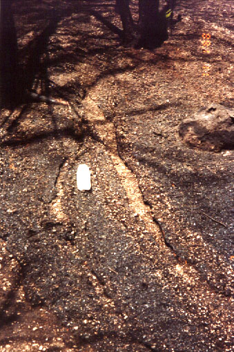
| Figure 5. Photograph of rills developed on hillslope following June 26, 1996, rainstorm. Rills were up to 4 cm deep, and 20 cm wide, with generally flat bottoms. Water bottle in center of photograph is 20 cm long. |
The long, smooth slopes that are present due to the mantling of the El Cajete pumice showed abundant rilling where the low-density pumice fragments, ash, charcoal, and pine needles were rafted along the surface of water flows and deposited as levees lining the paths of the flows. That the low-density materials were rafted along the surface of the flows, rather than being incorporated into a slurry, might have prevented the erosion commonly associated with the passage of debris flows.
Dry-ravel concentrations: Dry-ravel deposits are formed by the particle-by-particle transport of material downslope due to gravity. This process has been observed on steep slopes both following, and during fires, where loose, noncohesive material was formerly anchored by vegetation. Dry ravel has been described as an important post-fire process in southern California, where channels are loaded with sediment, increasing available sediment for large events (e.g., Florsheim, et al. 1991; Wells, 1987). Cannon et al., (1995) also described aprons of dry-ravel material mantling hillslopes and lining channels; these deposits were subsequently eroded in a high intensity rainfall event, resulting in destructive debris flows.
Very few accumulations of dry-ravel deposits were observed in the Capulin Creek drainage. Some dry-ravel material was observed along trails, where small, 0.3 meter high, nearly vertical cuts into hillsides supplied material. These deposits were localized, and on average approximately 0.25 m high, 0.20 m wide, and formed slopes between 20 and 30%. No accumulations of dry-ravel materials were observed in tributaries to Capulin Creek, nor were significant accumulations observed on hillsides.
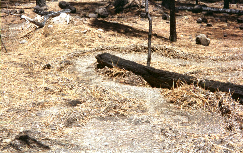
| Figure 6. Photograph of debris flow generated on hillslopes during the June 26, 1996, rainstorm. The path of the flow is lined by levees up to 15-cm high. The levees consist of pine needles, pumice and charcoal fragments, and some silty matrix. Note that the flow was deflected around the burnt log in the center of the photograph. |
The assessment of the development of a hydrophobic layer in the soil in Bandelier National Monument involved digging a small pit with clean, inclined sides. Pits were, in general, about 10 cm deep, with one side inclined at about 3:1. Water from a squirt bottle was dripped along the incline. Hydrophobicity was identified if the water beaded on the surface and did not infiltrate for at least one minute. Where hydrophobic material was found, its lateral extent was evaluated by dripping more water on either side within in the pit. In addition, a minimum of three other nearby pits were dug to determine if the layer was laterally continuous.
Hydrophobic soils were observed at only four of the 15 test sites in Bandelier, three of which were located in the areas of highest intensity fire. The hydrophobicity was extremely localized within the soils, and was nowhere laterally continuous. For example, at site 5 (Figure 3), a hydrophobic, 4-cm thick, light tan, dry silt loam was observed beneath 3 cm of black ash and pumice and 3 cm of slightly moist brown silt loam. This layer was not continuous within the pit, and just one of three additional soil pits dug nearby showed only patchy hydrophobicity. Similar conditions were observed at the other three sites. Note also that additional sites in high burn intensity areas did not exhibit any hydrophobicity.
In one location the material exposed in the base of the rills formed by the June rainfall exhibited some hydrophobicity, but this was not observed at any other site.
Condition of riparian vegetation: A map of fire intensity generated by the U.S Forest Service from 1:12,000-scale aerial photography taken after the fire and limited field checking was used to assess the condition of the riparian vegetation. A portion of this map is shown in Figure 2. Areas mapped as high fire intensity are characterized by essentially 100% tree mortality and total consumption of tree needles and ground cover. Moderate fire intensity is characterized by 80 to 100% tree mortality, but scorched needles remained on most of the trees. The duff and needle layer was generally intact. Areas mapped as light burn intensity experienced generally less than 20% tree mortality, and duff and older needle cast remain intact. Note that a considerable gap between the light and moderate designations in percent tree mortality. This is due to the character of the Dome fire, which tended to be either a light ground fire with little tree mortality, or a crown fire with nearly total tree mortality. Of further note, in aerial photographs crown-fire conditions appear as very high intensity burn, and although crown fires are very hot in the tops of trees, the ground does not necessarily experience these high temperatures. Thus, this map might not be entirely representative of conditions on the ground. It is, however, the best tool available.
The Forest Service map of fire intensity shows a 0.8-km-long reach of moderate intensity burn with a few patches of high intensity at the very head of Capulin Canyon. Immediately upstream from the edge of Figure 2 (and thus not shown on the figure), a 1.1-km-long reach of moderate intensity burn is mapped adjacent to a 1.1-km-long section of high burn intensity. This is the only extensive zone of riparian vegetation that experienced high fire intensity. The map also shows an approximately five-km-long reach of Capulin Creek extending downstream from the edge of the map in Figure 2 to the Base Camp that experienced light fire intensity. An additional one-km-long reach of light fire intensity was mapped 1.6 km downstream from the Base Camp.
Over a total length of approximately 20 km, approximately 6% of the riparian vegetation in Capulin Canyon experienced high fire intensity, 10% experienced moderate intensity, and 30% was impacted by light intensity burn. The riparian vegetation in the two ephemeral drainages that head on the south side of Boundary Peak and join Capulin Creek just upstream from Painted Cave was not impacted by the fire. In these areas, as well as the unburned length of Capulin Creek, the vegetation lining the creek continues to intercept rainfall and absorb raindrop impact, mulch the ground surface, and supply structural support of loose, surficial material and reinforcement of the deeper soil by roots.
Condition of fibrous root mat: Destroying the fibrous root mat beneath the surface reduces the soil cohesion and can thus result in accelerated erosion by surface overland flow. The root mat was observed in July to be intact even in areas of high fire intensity. In some locations, the root mat appeared to control the depth of the rills that formed as a result of the June 26 rainfall. Note that in areas where the vegetation was killed by the fire, the root mat will eventually decompose, and the cohesion element lent to the soil will be lost.
Continuity of burn mosaic: The continuity of the burned mosaic influences the area of hillslope upon which erosion can potentially occur. An spatially extensive high-intensity-burned area will produce considerably more material that an area that has been spottily burned by a low intensity fire. The map of fire intensity generated by the U.S Forest Service from 1:12,000-scale aerial photography taken after the burn and some field checking was used to assess the continuity of the burn mosaic.
For the entire Dome fire, 1281 ha, or 19% of the total burned area of 6684 ha was mapped as high intensity burn, 1411 ha, or 21% was mapped as moderate intensity burn, 1159 ha, or 17% as light. The remaining 2832 ha, or 42% are mapped as no burn or low intensity. The distribution of burn intensities for the Dome fire indicates a rather spotty burn mosaic, although at this time there is no method to quantitatively determine how continuous the burn mosaic must be in order to generate debris flows.
Evidence of Past Debris-Flow Activity
The fact that some debris-flow activity occurred during the summer monsoon season indicates that conditions do exist in Capulin Canyon that can produce debris flow. The scale of these two events was, however, very small, and it remains to determine if Capulin Canyon is susceptible to large-scale, highly destructive debris-flow events, and if so, if fires played any part in their initiation. The Capulin Creek drainage and its tributaries from the western margin of the map in Figure 3 to just below Painted Cave were thus examined for evidence of large-scale past debris-flow activity. Although no definitive evidence of recent, pre-fire debris-flow activity was observed, and most of the high-energy deposits in the canyon, of which there are many, appear to be unequivocally those of dilute stream flow (i.e. abundant open framework and imbricated boulder and cobble bars that contain very little matrix, or well-sorted deposits of boulders and cobbles in a sandy matrix) (Figure 7), some possible debris-flow deposits were detected. At location D on Figure 3, a large lobe of material approximately 2-m high and at least 5-m wide consisting of boulders and cobbles up to 1 m in diameter in an abundant silty matrix nearly fills the canyon bottom. The grain-size distribution of the matrix material is presently being determined. The right margin of the deposit, located 10 meters from the hillside, is very distinct and slopes steeply (41 degrees) up to a gently undulating surface. Numerous Ponderosa pine are growing on the deposit surface. The deposit rests on a 3 degree slope. The leading edge of the lobe (or the snout) is considerably less distinct than the right margin as it appears to have failed by a series of slumping events following deposition. If this is indeed a lobe of debris-flow material, the leading edge would have been greater than 2-m thick and with a very steep slope, and could have failed easily after deposition. The left side of the deposit has been eroded by Capulin Creek and thus the flow margin is not discernible. No evidence that could indicate the age of this deposit was observed, nor were any indications of its relation to the fire history in the canyon.
Alluvial fans that have formed at the junctions of some tributaries with Capulin Canyon were examined for evidence of possible debris-flow activity. A small fan has formed at the mouth of the small tributary drainage immediately down channel from location D in Figure 3, and the morphology of a deposit located on the right channel bank suggests the possibility of a set of nested debris flow levees. The deposits contain boulders up to 0.5-m in diameter in abundant matrix material. The grain-size distribution of this material is presently being determined. The nested morphology may also be a result of incision into the fan by the tributary stream. In addition, the two major tributaries that join Capulin Creek near Painted Cave (Figure 3) have deposited a significant amount of material at the juncture. Stream cuts into these fans show thick, poorly sorted, and boulder-rich deposits that could possibly be those of debris flow. However, the difficulties in determining debris-flow origin of older deposits makes this judgment rather uncertain. No other indications of historic debris-flow activity were observed in the section of the canyon examined.
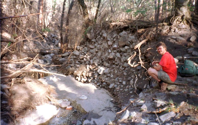
| Figure 7. Photograph of typical high-energy streamflow deposits in Capulin Canyon. The deposits consist of boulders in a loose, sandy matrix. Note that the incision of bedrock occurred during the June 2, 1996, rainfall event. |
Some indication of the historic response of the watershed to fire events was discovered in an incision into a fan surface of the tributary labeled E in Figure 3. This stream cut exhibited a stratigraphy similar to the sheetflood sediments deposited on the flood plain of Capulin Creek itself during June flooding—lenses of primarily sandy matrix containing some cobbles and pebbles, resting on silty sands. Two buried soils were observed separating packets of these units, and the presence of abundant charcoal fragments and ash within these soils indicates that fires have occurred in the watershed in the past. C-14 dates of 1650-1950 A.D., and 1280-1630 A.D. were obtained from charcoal in the upper, and lower soils, respectively. The internal stratigraphy of the fan, however, did not indicate the occurrence of debris flows following these fires, and the fan surface is covered with abundant openwork boulder and cobble berms, again made up of clast-supported and imbricated materials.
Of further interest is the response in canyons north of Capulin Canyon following the 1977 LaMesa fire. This fire is reported to have been the largest and most intense fire to burn in the Jemez Mountains this century (Allen et al., 1996). Unexceptional summer thunderstorms resulted in large flood events in Frijoles Canyon, but debris flows were not described (White, 1981). This fire was reported to have been more intense, and produced a less spotty burn mosaic than the Dome fire (C.Allen, personal commun., 1996).
The results of this examination indicate that while there has been significant high-energy flooding in Capulin Canyon the past, large-scale debris-flow does not appear to have been particularly widespread. The evidence observed in the canyon would seem to indicate that the watershed response to fires or to severe meteorological events in the past has been primarily as flooding, but not definitively debris flow. This response might, however, be due to the less intense and extensive character of fires in the past.
Based on the following observations, the potential for significant debris- and hyperconcentrated-flow activity in Capulin Canyon itself as a result of the Dome fire is determined to be low.
A) Even though evidence of the occurrence of fires in the past was observed in Capulin Canyon, evidence of resultant widespread debris- and hyperconcentrated-flow activity was not detected. However, the preponderance of high-energy streamflow deposits in the canyon indicates that the prevailing hazard is that of flooding with considerable sediment bulking.
B) The June 26, 1996 thunderstorm produced abundant surface overland flow and rilling, and transported low-density pumice, charcoal, ash and some mineral soil from the hillslopes as non-erosive, and small-scale debris flows. Runoff from this event also transported cobble and boulder-sized material short distances in some locations. Deposits from only two debris flows of significant volume were observed resulting from the entire summer thunderstorm season.
C) Evaluation of the geologic and geomorphic factors identified as contributing to post-fire debris-flow activity does not indicate a major propensity for debris-flow activity. Note that the relative influence of each of these factors is not known, and methods for evaluating quantitatively the influence of these factors do not exist at this time. These factors were evaluated qualitatively for this report.
A moderate potential for debris and hyperconcentrated flow, however, does appear to exist for the two major tributary drainages that join Capulin Canyon near Painted Cave. These two tributaries show possible sedimentological evidence for past-debris flow activity, and a very fluid debris flow occurred in the northern tributary in the summer of 1996.
Based on the definition of a moderate potential for debris and hyperconcentrated flow for the two major tributaries to Capulin Canyon, we recommend that recreational activity downstream from these tributaries be restricted for at least one year. Assessment of the state of vegetation recovery on the hillslopes in the headwaters of the tributaries should continue, as should monitoring of hillslope response to summer thunderstorms. Once vegetation is sufficiently reestablished such that summer thunderstorms no longer produce abundant surface overland flow, the hazard will be mitigated. Note that such mitigation occurred within two years in the steep drainages of Storm King Mountain, near Glenwood Springs, Colorado, that were burned by the 1994 South Creek fire.
In Capulin Canyon itself, however, the remaining prevalent hazard is that of flooding with considerable sediment bulking. Most of the movement of material from the hillslopes following the Dome fire occurred during the first significant thunderstorm of the season, perhaps due to compaction of the soil surfaces by raindrop impact, as suggested by Meyer, et al. (1995). Response to later thunderstorm events was dominated by high-energy dilute stream flows and considerable incision and movement of material in the main channel. Further, stratigraphic evidence in the canyon indicated that the watershed response to fires and severe meteorological events in the past has been primarily as flooding, but not definitively debris flow. The report prepared by Jack Veenhuis of the U.S. Geological Survey, Water Resources Division for the Monument should address the issues associated with flood hazards in Capulin Canyon.
| NEXT | PREVIOUS | TOP |
| AccessibilityFOIAPrivacyPolicies and Notices | |
| |
|