![]()
U.S. DEPARTMENT OF THE INTERIOR
U.S. GEOLOGICAL SURVEY
OPEN-FILE REPORT 97-272
The Areal Extent of Continuous Type Gas Accumulations
in Lower Silurian Clinton Sands and Medina Group Sandstones of the Appalachian
Basin and the Environments Affected by their Development
By C.J. Wandrey, Robert T. Ryder, Vito F. Nuccio, and
Kerry L. Aggen
|
 |
||||||||||
|
|
||||||||||
 |
|||||||||||
[Back]
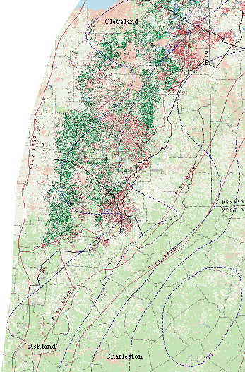
In order to best preserve and manage our energy and natural resources we must understand the relationships between these resources and the impacts of their development. To further this understanding the U.S. Geological Survey is studying unconventional continuous-type and, to a lesser extent, conventional oil and gas accumulations and the environmental impacts associated with their development. Continuous-type gas accumulations are generally characterized by low matrix permeabilities, large areal extents, and no distinct water contacts. This basin scale map shows the overall extent of these accumulations and the general land use types that may be impacted by their development.
The Appalachian Basin has the longest history of oil and gas exploration and production in the United States. Since Drake's Titusville discovery well was drilled in 1859, oil and gas has been continuously produced in the basin. While there is still a great deal of oil and gas production, new field discoveries are rare and relatively small. For most of the second half of the 20th century the Appalachian basin has been considered a mature petroleum province because most of the large plays have already been discovered and developed.
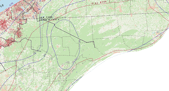
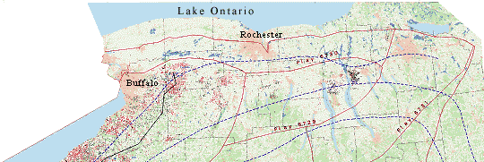
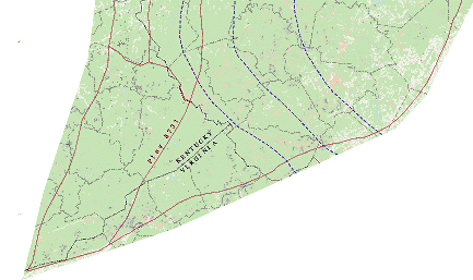
One exception to this trend is the Lower Silurian Clinton Sands and Medina Group Gas play which is being developed in New York, Pennsylvania, and Ohio. This continuous-type gas play has been expanding since the early 1970's (see inset maps). In the 1980's economic incentives such as large increases in wellhead prices further stimulated continuous-type gas resource development.
Continuous-type gas plays can be large in areal extent and in thickness. "Sweetspots" (areas of greater prodcution) are hard to predict and generally associated with better than average permeabilities, and enhanced by natural fracture systems. With an overall success rate often approaching 90%, drilling most of the play with closely spaced wells is often the best way to maximize gas recovery.
Some positive economic characteristics associated with the development of these continuous-type accumulations are high success rates, low drilling and development costs, and low water production, which results in low water disposal costs. Large areas within the Appalachian basin with good potential for this type of gas accumulation remain to be tested. Positive environmental characteristics include, a clean energy source, low water production, and relatively low surface impact.
Some negative characteristics associated with these continuous -type accumulations are low individual well production rates and small well drainage area. Negative environmental characteristics are primarily related to the dense well spacing used to develop the resource to its full potential. Often negative environmental impacts such as surface disturbance can be greatly reduced. The number of well sites can be decreased by using a single centrally located surface location and associated facilities for several directionally or horizonatally drilled wells. This also minimizes the transportation infrastructure (access roads and pipelines) required to maintain the wells and deliver the gas. Visual impacts can be reduced by selecting well locations visible only over short distances.
While the prospective area is large, potential decreases basin- ward and toward the northeast and southwest. These areas are represented by the lower potential plays 6727, 6730, and 6731.
The U.S. Geological Survey landuse and landcover data was derived from USGS 1:250,000 and 1:100,000 scale maps. This information was collected between the mid 1970s to mid 1980s. The land use and land cover data was mapped and coded using the Anderson classification system (Anderson, 1975) which is a hierarchical system of general (level 1) to more specific (level 2) characterization. Level 1 characterization was used for this map; the land use and land cover designations are displayed below in the Explanation.
The oil and gas exploration information was derived using data from the June 1993, version of the Well History Control System files of Petroleum Information Corp., Houston Texas. Completeness of the data used varies across the basin. The data were summarized and converted to cell representations using a modified version of a system developed by R. F. Mast and David Root for the U.S. Geological Survey's 1995 National Assessment of United States Oil and Gas Resources. The programs are more completely described in Mast and Beeman, 1996.
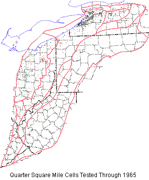
Each cell on the map represents 1/4 square mile where exploration has occured and the Lower Silurian was penetrated. There may be any number of wells within a cell and the color assigned represents the highest value of that cell. The value of the cell may be: dry, gas, oil, or oil and gas based on the values assigned to each well within the cell. For the national oil and gas assessment, cell sizes equal to the median spacing of the expected drainage area for wells in the play area were used to determine the potential of the play.
In the play with the best potential for producing gas (play 6728) which encompasses 16,901 sq. miles (270,416 40 acre cells), there were 15,941 productive cells or 5.9% of the total cells in the play. Play 6729, which has medium potential, covers an area of 3,780 sq. miles (60,480 40 acre cells) and has 340 productive cells or .5% of the total cells in the play. Play 6730, which has medium to low potential, and encompasses 8,098 sq. miles (129,568 40 acre cells) and contains 16 productive cells or .01% of the total cells in the play. Play 6731 was not quantitatively assessed because it has no production from the Clintion/Medina interval.
The cells used for the inset development history maps were processed and displayed with a 1 sq. mile cell size.
[Back]
The play descriptions and boundaries used here were defined by Ryder (1995) for the U.S. Geological Survey's 1995 National Assessment of United States Oil and Gas Resources (Ryder, 1995). (See also Gautier and others, 1995; Beeman and others, 1996; Charpentier and others, 1996).
The continuous-type Clinton/Medina Sandstone Gas plays consist of portions of the Lower Silurian depositional system characterized by low-permeability reservoirs, abnormally low formation pressure, lack of structural traps, and a high percentage of wells with gas shows or production. These plays, numbered 6728 through 6731, are differentiated primarily by their undiscovered potential as shown below.
6728. Clinton/Medina Sandstone Gas High Potential
6729. Clinton/Medina Sandstone Gas Medium Potential (HYPOTHETICAL)
6730. Clinton/Medina Sandstone Gas Medium-Low Potential (HYPOTHETICAL)
6731. Clinton/Medina Sandstone Gas Low Potential (HYPOTHETICAL)
Stratigraphically, the plays involve the "Clinton" sands and the subunits red, white, and stray Clinton sands of drillers usage in Ohio; and the Medina Group including the Whirlpool Sandstone, Cabot Head Shale, and Grimsby Formation in New York and Pennsylvania. The "Clinton" sandstone (or sands) in Ohio correlates with the Lower Silurian Medina Group of New York and not with the Middle Silurian Clinton Group of New York as originally believed; however, the term is so popular in the petroleum industry that its usage continues. Porosity for the reservoirs ranges from 3 to 11 percent and averages 5 percent. Permeability is as high as 0.2 to 0.6 mD but it generally averages less than 0.01 mD. The thickness of the Clinton sandstone sequence and the Medina Group in the plays ranges from 120 to 210 ft, and sandstone to shale ratios vary from 0.6 to 1. The net reservoir thickness ranges from 2 to 90 ft and averages about 25 ft. Drilling depths to the sandstone reservoirs in eastern Ohio and northwestern Pennsylvania range from 4,000 to 6,300 ft and in southwestern Pennsylvania the drilling depth may be as much as 10,000 ft. In New York the drilling depths to the Medina Group are between 1,000 and 4,000 ft, whereas in southern Ohio and adjoining eastern Kentucky the drilling depths to the "Clinton" sandstone range from 2,000 to 3,000 ft.
Gas was first discovered in the Clinton/Medina Sandstone Gas High Potential play (6728), in the mid, to late 1880's in western New York and in the late 1890's in southern Ohio. Drilling depths to the Clinton and Medina sandstones in these regions range from less than 1,000 to about 2,000 ft; however, because of the low permeability of the Lower Silurian sandstones, most of the exploration was concentrated in east-central Ohio where reservoir quality was higher, and oil was produced as well as gas. By the late 1950's and early 1960's, exploration activity had successfully expanded into eastern Ohio, northwestern Pennsylvania, and western New York where lower quality sandstone reservoirs occur, drilling depths commonly exceed 4,000 ft, and gas is the principal hydrocarbon type. Successful exploration for gas continues today in sparsely drilled parts of the plays such as southern and east-central New York, northwestern Pennsylvania, and eastern Ohio. In Pennsylvania and Ohio, drilling depths to the Clinton and Medina sandstones exceed 6,000 ft. An offshore gas well drilled in 1958 in Pennsylvania and numerous offshore wells drilled since 1913 in Canada indicate that gas in the play extends into Lake Erie at least as far north as the United States-Canada border. Most sandstone reservoirs in the play have "tight" formation status.
The most important factor that assured exploration success in low-permeability sandstone reservoirs was the development of hydraulic fracturing techniques. Wells that originally had a very low natural flow of gas were transformed by hydraulic stimulation into wells producing as much as 1-2 million cubic feet of gas per day (MMCFGPD). Field size has little meaning in the plays because older fields tend to merge together into continuous-type accumulations with additional drilling. For example, the three or four Medina gas fields that were discovered in the 1960's in Chautauqua County, western New York, have now merged into the giant Lakeshore field, which has an ultimate recovery of about 650 billion cubic feet of gas (BCFG).
Estimated ultimate recovery (EUR) values for producing wells in the Clinton/Medina Sandstone Gas High Potential Play (6728) range from 5 (F95) to 330 (F5) million cubic feet of gas (MMCFG) and have a median (F50) of about 70 MMCFG. Smaller EUR values are recorded for producing wells in the Clinton/Medina Sandstone Gas Medium Potential Play (6729); they range from 5 to 150 MMCFG) and have a median (F50) of about 50 MMCFG. Low EUR values, high risk, and a low success ratio are assigned to the Clinton/Medina Sandstone Gas Medium-Low Potential (6730) and Clinton/ Medina Sandstone Gas Low Potential Plays (6731). These estimates were all made assuming a well spacing of 40 acres.
ADJACENT CONVENTIONAL PLAYS:
The unconventional Clinton/Medina Sandstone Gas plays 6728 through 6731 are contiguous with Lower Silurian conventional Tuscarora Sandstone Gas play (6727) and the conventional Clinton/Medina Sandstone Oil and Gas play (6732) (see map) that occupy the northwest and southeast parts of the widespread Lower Silurian sandstone depositional system which was primarily deposited in littoral marine, deltaic, and offshore-marine settings.
6727. Tuscarora Sandstone Gas play
The Tuscarora Sandstone Gas play is defined by gas trapped in the Lower Silurian Tuscarora Sandstone by low- amplitude basement-controlled anticlines commonly in combination with diagenetic traps. The most easterly of the Lower Silurian sandstone plays, this play covers large parts of New York, Pennsylvania, and West Virginia. The southwestern most end of the play includes small parts of Virginia and Kentucky. On the east side, the play is bounded by the approximate western limit of detached anticlines involving Upper Ordovician and older strata, whereas, on the west side, it is bounded by an arbitrary line separating the Tuscarora Sandstone from Clinton/Medina Sandstone Gas play. The play is confirmed with known production and its prospective reservoirs are conventional.
Porosity values are as high as 13 percent but generally average 4 percent or less. Permeability averages are less than 1 mD. The thickness of the Tuscarora Sandstone in the play ranges from about 100 to 325 ft, and sandstone to shale ratios generally exceed 3. Drilling depths to the Tuscarora Sandstone range from 5,000 to 11,000 ft. Basement-controlled anticlines and combination traps are the major traps in the play. The combination traps are formed by diagenetically produced permeability barriers that cross the flanks and noses of gently plunging, low-amplitude anticlines.
Gas production from the Tuscarora Sandstone was established in the mid-1970's by deeper drilling in the Campbell Creek- Malden and Hernshaw-Bull Creek oil fields in central West Virginia. The Indian Creek field, largest of three fields in Kanawha County, West Virginia, has an ultimate recovery of about 32 BCFG. Several subcommercial 1-well fields have been discovered in northern West Virginia and southern Pennsylvania along the trend of the Chestnut Ridge anticline. One of these accumulations, the Heyn pool, Fayette County, Pennsylvania, produces gas from fractured Tuscarora Sandstone probably caused by minor bedding-plane detachment in underlying Upper Ordovician shale. Additional 1-well, Tuscarora Sandstone fields are scattered around Pennsylvania and West Virginia and many of them are associated with basement-controlled anticlines. Exploration for gas fields in the Tuscarora Sandstone continues in Pennsylvania and West Virginia, at the rate of several drill holes per year.
This play has potential for a modest number of undiscovered gas fields greater than 6 BCFG. The most attractive aspect of the play is its lateral updip continuity with the prolific oil and gas fields of theClinton and Medina sandstones. In addition, there are largeareas in the play that have been sparsely drilled to the Tuscarora Sandstone, and some parts of prospective structures remain untested. Limiting factors in the play may be (1) low-quality reservoirs, (2) poor accessibility to known source rock sequences, and (3) a high percentage of noncombustible gas mixed with the methane gas.
6732. Clinton/Medina Sandstone Oil/Gas play
The Clinton/Medina Sandstone Oil/Gas Play (6732) is defined by oil and gas trapped in the Lower Silurian "Clinton" sandstones and Medina Group sandstones by facies- change stratigraphic traps and combination traps. The play is confirmed and classified as conventional, however it has many aspects of continuous-type accumulations such as abnormally low formation pressure, and a general lack of structural control.
Compaction and burial diagenesis have reduced the primary intergranular porosity of the sandstone reservoirs but not to as extreme a degree as in the sandstone reservoirs of the adjoining Clinton/Medina Sandstone Gas Plays. Porosity for reservoirs in the play ranges from 8 to 15 percent and averages 12 percent. Most of this porosity is primary intergranular porosity, but fracture porosity, caused by movement between basement-involved fault blocks, may be locally important. Permeability ranges from <0.1 to 75 mD and averages 5 mD. The thickness of the Clinton sandstone sequence and the Medina Group in the play ranges from 100 to 200 ft and sandstone to shale ratios range from 0.2 to 1.0. The net reservoir thickness ranges from 6 to 105 ft and averages about 40 ft. Drilling depths to the reservoirs in the play range from 1,000 to 5,000 ft.
Oil and gas were first discovered in the play in the mid-to late-1880's in Knox, Licking, Fairfield, and Perry Counties in east-central Ohio. Clinton sandstones are relatively shallow in this region and range from depths of 2,000 to 2,800 ft. In a short time, the trend had spread northward across all of east-central Ohio to the southern shore of Lake Erie. For about 70 years this region has yielded large quantities of oil and gas from reservoirs of good to moderate quality. Most of the oil and gas fields began to coalesce with later infill drilling. By the late 1950's and early 1960's, exploration for oil and gas in the Lower Silurian sandstones had successfully expanded into eastern Ohio where drilling depths were commonly greater than 4,000 ft and reservoir quality had diminished.
The most important factor that insured exploration success along the eastern part of the play was the development of hydraulic fracturing techniques. Wells that originally had very low natural flows of oil and gas were transformed by hydraulic stimulation into wells producing as much as 150 BOPD and 1 to 2 MMCFGPD. The largest oil field in the play is East Canton (Stark Co., Ohio, discovery date 1966, ultimate recovery ~100 MMBO). The exploration phase of the play is now over and sandstone reservoirs in its eastern parts have "tight" formation status.
Resource potential: The Clinton/Medina Sandstone Oil/Gas play has potential for a small number of undiscovered oil and gas fields greater than 1 MMBO or 6 BCFG. The undiscovered fields are in undrilled Lake Erie. Outside of Lake Erie, this play is exhausted except for very small oil and gas accumulations.

This graph shows the improvement in the success rate through time for oil
and gas cells. When the success rate improved, the exploration rate increased
significantly. Technology, economics, and politics were all contributing
factors. Significant increases in well head prices and changes in tax regulations
played an important role in lowering the threshold for an economically
successful well. Advances in drilling and completion techniques also improved
the success rate. Prices are in dollars.
The cells from all 6 plays were included; however the oil curve is primarily made up of cells from conventional play 6732. Most of the cells in the early portion of the gas curve are from play 6732. In most cases these gas wells were discovered during exploration for oil. The later contribution was primarily made up of cells from continuous-type play 6728.
[Back]
In an effort to characterize the thermal maturity of source rocks that have contributed to the gas resources in the Lower Silurian Clinton Sands and Medina Group, Appalachian Basin, a preliminary Vitrinite Reflectance Equivalent (VRE) map was constructed. The map was assembled using published thermal maturity data from Ordovician strata in the form of Conodont Alteration Indices (Harris, et al, 1978, Jenden et al., 1993, and Ryder and others, 1992), and Tmax values from Rock-Eval pyrolysis (Drozd and Cole, 1994, Ryder and others, 1991, and Wallace and Roen, 1989). To equibilrate the data, it was converted to a VRE, a parameter that is the most widely used in the petroleum industry. Although this map was necessarily constructed at the exact horizon of the Middle Ordovician Utica Shale (thought to be a potential source for gas), it should represent fairly closely, the general thermal maturity of that petroleum source rock. Five VRE lines which are illustrated representing important gas generation thresholds.
The 0.75 VRE line represents the onset of significant gas generation from source rocks containing types II and III organic matter (Meissner, 1984). The 1.10 VRE line is the threshold for intense gas generation and migration (Meissner, 1984). In the Uinta Basin, UT, a continuous type accumulation, tight reservoirs in the area of 1.10 VRE and higher are often overpressured and water-free. The 1.50 VRE line is for reference only. The 2.0 VRE line represents the level of maturity for maximum gas generation from types II and III source rocks (Meissner, 1984). The 3.0 VRE line illustrates an area of high thermal maturity in the basin and approaches the upper limit of gas preservation (Waples, 1980). Source rocks in the area between approximately 0.60 (onset of oil generation) and 1.35 (oil deadline) VRE are considered to be, or once were, in the oil generation window (Tissot and Welte, 1984).
The map illustrates that most Ordovician strata in the area of the Appalachian Basin shown, are mature for oil and gas generation. Further, the majority of the area is in the window of significant gas generation.
The conversion of Conodont Alteration Index (CAI)and Tmax to Vitrinite Reflectance used in this study is as follows: From Harris and others (1978), Jenden and others (1993), and Tissot and Welte (1984).
VRE             CAI                             Tmax

0.75            1.5                              440
1.10            2.0                              460
1.50            2.6                              480
2.0             3.2                              500
3.0             4.0                             >550
[Back]
Anderson, James R., 1975, A land use and land cover classification system for
     use with remote sensor data, U.S. Geological Survey Professional Paper 964.

Cardwell, D.H., 1977, West Virginia gas development on Tuscarora and deeper
     formations: West Virginia Geological and Economic Survey Mineral Resources
     Series 8, 38 p.

de Witt, Wallace, Jr., 1993, Principal oil and gas plays in the Appalachian
     Basin (province 131): U.S. Geological Survey Bulletin 1839-I. 37 p.

DeBrosse, T.A., and Vohwinkel, J.C., 1974, Oil and gas fields of Ohio: Ohio
     Division of Geological Survey (in cooperation with the Ohio Division of
     Oil and Gas), 1 sheet, scale 1:500,000.

Drozd, R.J., and Cole, G. A., 1994, Point Pleasant--Brassfield Petroleum
     System, Appalachian Basin, U.S.A., in Magoon, L.B., and Dow, W. G., eds,.
     The Petroleum system--from source to trap:  American Association of
     Petroleum Geologists Memoir 60, p. 387-398.

Gautier, Donald L., Dolton, Gordon L., Takahashi, Kenneth I., and Varnes,
     Katharine L., editors, 1995, 1995 National Assessment of United States
     Oil and Gas Resources-Results, Methodology, and Supporting Data, U.S.
     Geological Survey Digital Data Series DDS-30

Harper, J.A., 1992, Review of the 1980's and prospective trends for the
     1990's, in Harper, J.A. and Cozart, C.L., Oil and gas developments in
     Pennsylvania in 1990 with ten-year review and forecast: Pennsylvania
     Topographic and Geologic Survey Progress Report 204, p.37-55

Harris, A. G., Harris, L. D., and Epstein, J. B., 1978, Oil and gas data
     from Paleozoic rocks in the Appalachian Basin--Maps for assessing
     hydrocarbon potential and thermal maturity (conodont color alteration
     isograds and overburden isopachs):  U.S. Geological Survey
     Miscellaneous Investigations Map I-91E-7, scale 1:2,500,000
     4 sheets.

Jenden, P. D., Drazan, D. J., and Kaplan, I. R., 1993, Mixing of thermogenic
     natural gases in northern Appalachian Basin:  The American Association
     of Petroleum Geologists Bulletin, v. 77, no. 6, p. 980-998.

U.S. Geological Survey, 1977, Land use and land cover and associated maps
     for Buffalo, New York, and Pennsylvania, U.S. Geological Survey
     Open-file Report 77-113.

U.S. Geological Survey, 1977, Land use and land cover and associated maps for
     Bluefield, West Virginia, U.S. Geological Survey Open-file Report 76-32.

U.S. Geological Survey, 1977, Land use and land cover and associated maps for
     Charleston, West Viriginia, U.S. Geological Survey Open-file Report 76-33.


U.S. Geological Survey, 1977, Land use and land cover and associated maps for
     Clarksburg, West Virginia, U.S. Geological Survey Open-file Report 76-35.

U.S. Geological Survey, 1977, Land use and land cover and associated maps for
     Cleveland, Ohio, U.S. Geological Survey Open-file Report 77-105.

U.S. Geological Survey, 1976, Land use and land cover and associated maps for
     Cumberland, West Virginia, U.S. Geological Survey Open-file Report 76-36.

U.S. Geological Survey, 1977, Land use and land cover and associated maps for
     Erie, Pennsylvania, U.S. Geological Survey Open-file Report 77-112.

U.S. Geological Survey, 1977, Land use and land cover and associated maps for
     Harrisburg, Pennsylvania, U.S. Geological Survey Open-file Report 77-109.

U.S. Geological Survey, 1976, Land use and land cover and associated maps for
     Huntington, West Virginia, U.S. Geological Survey Open-file Report 76-37.

U.S. Geological Survey, 1976, Land use and land cover and associated maps for
     Jenkins, West Virginia, U.S. Geological Survey Open-file Report 76-38.

U.S. Geological Survey, 1977, Land use and land cover and associated maps for
     Pittsburgh, Pennsylvania, U.S. Geological Survey Open-file Report 77-110.

U.S. Geological Survey, 1978, Land use and land cover and associated maps for
     Scranton, Pennsylvania, New Jersey, and New York, U.S. Geological
     Survey Open-file Report 77-664.

U.S. Geological Survey, 1977, Land use and land cover and associated maps for
     Warren, Pennsylvania, U.S. Geological Survey Open-file Report

U.S. Geological Survey, 1977, Land use and land cover and associated maps for
     Williamsport, Pennsylvania, U.S. Geological Survey Open-file Report 77-107.

Law, Ben E., and Spencer Charles W., 1993, Gas in Tight Reservoirs--An Emerging
     Major Source of Energy, in Howell, D.G., ed., The Future of Energy Gases,
     U.S. Geological Survey Professional Paper 1570, p.233-252.

Mast, R.F. and Beeman, W.R., 1996, Appendix F, Documentation for exploration
     cell maps, in Beeman, W.R., Obuch, R.C., and Brewton, J.D., compilers,
     1996, Digital map data, text, and graphical images in support of the
     1995 National Assessment of United States Oil and Gas Resources,
     U.S. Geological Survey Digital Data Series DDS-36, 1 CD-ROM.

Meissner, F. F., 1984, Cretaceous and Lower Tertiary coals as source
     for gas accumulation in the Rocky Mountain area, in Woodward, Jane,
     Meissner, F. F., and Clayton, J. L., eds., Hydrocarbon source
     rocks of the greater Rocky Mountain  Region:  Denver, Rocky
     Mountain Association of Geologists, p. 401-432.

New York State Department of Environmental Conservation, Division
     Mineral Resources, Bureau of Oil and Gas Regulation, 1995, Oil and
     Gas Database.

New York Department of Environmental Conservation, 1986, New York State oil
     and gas fields: Department of Environmental Conservation, Division of
     Mineral Resouces, 1 sheet, scale 1:250,000.


Ohio Geological Survey, 1994, State of Ohio Oil and Gas Database.

Ohio Geological Society, 1985, Clinton sandstone papers presented at the
     Ohio Oil and Gas Association winter meetings 1961 to 1978: Columbus,
     Ohio Geological Society, 228 p.

Ohio Geological Society, 1985, The new Clinton Collection (reprinted 1987
     with one additional paper): Columbus, Ohio Geological Society, 257 p.

Pennsylvania Topographic and Geological Survey, 1995, Pennsylvania Oil
     and Gas Database:  Petroleum Information Corporation, Houston, Texas.

Petroleum Information Corporation, 1993, Well History Control System
     Northeastern United States Database.

Petroleum Week, 1959, Second American-side test opens drilling season
     on Lake Erie: Petroleum Week, May 1, 1959, p. 28-29.

Piotrowski, R.G., 1981, Geology and natural gas production of the Lower
     Silurian Medina Group and equivalent rock units in Pennsylvania:
     Pennsylvania Topographic and Geologic Survey Mineral Resource Report 82,
     21 p., 11 plates.

Ryder, Robert T., 1995, Appalachian Basin Province 67, Gautier, D.L., Dolton,
     G.L., Takahashi, K.I., and Varnes, K.L., eds., in 1995 National Assessment
     of United States Oil and Gas Resources--Results, Methodology, and
     Supporting Data, U.S. Geological Survey Digital Data Series DDS-30.

Ryder, Robert T., Burruss, R. C., and Hatch, J. R., 1991, Geochemistry of
     selected oil and source rock samples from Cambrian and Ordovician strata,
     Ohio-West Virginia-Tennessee part of the Appalachian basin:  U.S.
     Geological Survey Open-file Report 91-434, 71 p.

Ryder, Robert T., Harris, A. G., and Repetski, J. E., 1992, Stratigraphic
      framework of Cambrian and Ordovician rocks in the central Appalachian
      basin from Medina County, Ohio, through southwestern and south-central
      Pennsylvania to Hampshire County, West Virginia:  U.S. Geological Survey
      Bulletin 1839K, 32 p.

Ryder, Robert T., Hettinger, Robert D., Law, Ben E., Miller, John J., Nuccio,
     Vito F., Perry, William J., Prensky, Stephen E., SanFilipo, John R., and
     Wandrey, Craig J., 1995, Continuous gas accumulations in "Clinton" sands
     and Medina Group sandstones in the Appalachian basin: A progress report of
     FY1995 activities, 11 p.

Ryder, Robert T., 1996, Appalachian Basin Province 67, in Beeman, William R.,
     Obuch, Raymond C., and Brewton, James C., Compilers, Digital Map Data,
     Text, and Graphical Images in Support of the 1995 National Assessment of
     United States Oil and Gas Resources, U.S. Geological Survey Digital Data
     Series DDS-35.

Shyer, E.C., 1989, Historical Digest: Medina Sandstone: New York State Oil and
     Gas Drilling and Production 1988, New York Division of Mineral Resources,
     p. 27-33

Smosna, Richard, and Patchen, Douglas, 1978, Silurian evolution of central
     Appalachian basin: American Association of Petroleum Geologists Bulletin,
     v. 62, no. 11, p. 2308-2328.

Tissot, B.P., and Welte, D. H., 1984, Petroleum formation and occurrence, second
     edition: Berlin, Springer-Verlag, 699 p.

Wallace, L. G., and Roen, J. B., 1989, Petroleum source rock potential of the
     Upper Ordovician black shale sequence, northern Appalachian Basin:  U.S.
     Geological Survey Open File Report 89-488, 66 p.

Waples, D.W., 1980, Time and temperature in petroleum formation: Application of
      Lopatin's method to petroleum exploration: American Association of
      Petroleum Geologists Bulletin, v. 64, p. 916-926.

Zagorski, W.A., 1991, Trapping models for the Lower Silurian Medina Sandstone
      Group--A comparison of trapping styles and exploration methodology for both
      "deep" and "shallow" Medina plays in the Appalachian basin [abs.]: American
      Association of Petroleum Geologists Bulletin, v. 75, no. 8, p. 1392.

![]() U.S. Department of the Interior | U.S. Geological Survey
U.S. Department of the Interior | U.S. Geological Survey
URL: http://pubsdata.usgs.gov/pubs/of/1997/ofr-97-0272/index.html
Page Contact Information: Central Energy Data Management
Questions or Assistance: Contact USGS
Last modified: Wednesday, 07-Dec-2016 16:31:33 EST