 Summary Summary
Version 1.1 of this Open-File Report contains a digital geologic map and map database of the Fawnskin 7.5' quadrangle, San Bernardino County, California, that includes:
- ARC/INFO (Environmental Systems Research Institute) version 7.2.1 double-precision coverages of the various elements of the geologic map
- A PostScript (.ps) file to plot the geologic map on a topographic base, containing a Correlation of Map Units diagram and a Description of Map Units
- Portable Document Format (.pdf) files of:
a. This Readme; includes in Appendix I, data contained in fskn_met.txt
b. The same graphic as plotted in 2 above. (Test plots from this .pdf do not produce 1:24,000-scale maps. Adobe Acrobat page-size settings control map scale.)
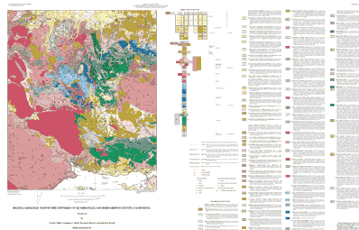
This release includes features not found in most other digital geologic maps, in that all polygons, lines, and points in the coverage are encoded with detailed, comprehensive geologic data contained in six INFO data tables (.rel). (See Matti and others, 1998a, 1998b, and 1998c, for information on how the encoding may be accessed and utilized.) No paper map is included in the Open-File Report, but a PostScript plot file containing an image of the geologic map sheet, topographic base, Correlation of Map Units (CMU), and detailed Description of Map Units (DMU) is. The Correlation of Map Units and Description of Map Units are in the editorial format of USGS Miscellaneous Investigations Series maps (I-maps) but have not been edited to comply with I-map standards. Within the geologic map data package, map units are identified by such standard geologic-map criteria as formation name, age, and lithology. Even though this is an author-prepared report, every attempt has been made to closely adhere to the stratigraphic nomenclature of the U.S. Geological Survey. Descriptions of units can be obtained by viewing or plotting the .pdf file (3b above) or plotting the PostScript file (2 above). If roads in some areas, especially roads that parallel topographic contours, do not show well on plots of the geologic map, we recommend use of the USGS Fawnskin 7.5' topographic quadrangle in conjunction with the geologic map.
|
First posted June 5, 2002
Data
Maps files
- Map PS.GZ (4.6 MB)
Full-color geologic map of the Fawnskin quadrangle at 1:24,000 scale on the topographic base, including a detailed Correlation of Map Units diagram, and an expanded Description of Map Units, in plottable Postscript format
Part or all of this report is presented in Portable Document Format (PDF). For best results viewing and printing PDF documents, it is recommended that you download the documents to your computer and open them with Adobe Reader. PDF documents opened from your browser may not display or print as intended. Download the latest version of Adobe Reader, free of charge.
|

