
U.S. DEPARTMENT OF THE INTERIOR
BRUCE BABBITT, Secretary
U.S. GEOLOGICAL SURVEY
Charles G. Groat, Director
This report is preliminary and has not been reviewed for conformity with U.S. Geological Survey (USGS) editorial standards or with the North American Stratigraphic Code. Any use of trade, firm, or product names is for descriptive purposes only and does not imply endorsement by the U.S. Government.
1U.S. Geological Survey, 4200 University Dr., Anchorage AK 99508-4667
2U.S. Geological Survey, P.O. Box 80586, Fairbanks, AK 99708-0586
3Pacific Rim Geological Consulting, P.O. Box 81906, Fairbanks, AK 99708-1906
This publication consists of the online version of a CD-ROM publication, U.S. Geological Survey Open-File Report OF98-133-A. The data for this publication total 356 MB on the CD-ROM and 331 MB for this online version. This online version does not include the Acrobat Search index files. It also has a link rather than files for the Adobe Acrobat Reader installer mentioned below. Version 1.0 of the CD-ROM may be purchased for $32 by calling 1-(888) ASK-USGS. You should then use the new CAKUNITS files provided here and note the erata sheet for work in progress.
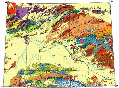
This map and associated digital databases are the result of a compilation and reinterpretation of published and unpublished 1:250,000- and limited 1:125,000- and 1:63,360-scale mapping. The map area covers approximately 416,000 sq km (134,000 sq mi) and encompasses 25 1:250,000-scale quadrangles in central Alaska. The compilation was done as part of the U.S. Geological Survey National Surveys and Analysis project, whose goal is nationwide assemble geologic, geochemical, geophysical, and other data. This map is an early product of an effort that will eventually encompass all of Alaska, and is the result of an agreement with the Alaska Department of Natural Resources, Division of Oil And Gas, to provide data on interior basins in Alaska. A paper version of the three map sheets has been published as USGS Open-File Report 98-133. Two geophysical maps that cover the identical area have been published earlier: "Bouguer gravity map of Interior Alaska" (Meyer and others, 1996); and "Merged aeromagnetic map of Interior Alaska" (Meyer and Saltus, 1995). These two publications are supplied in the "geophys" directory of this report.
This report contains Adobe Acrobat PDF files. Using Adobe Reader (available using the button, below), you can view, navigate, and print many of the parts of this report.

View an errata sheet (errata.pdf, 149 KB) for this publication. This file, dated February 07, 2000, is in Adobe Acrobat PDF format.
Read the main text for this report (text/OF98_133.pdf, 616 KB) .
Get PDF versions of the maps (3_PDF files). The files in this folder can also be viewed by using the links below:
Get EPS versions of the maps (2_EPS_files).
Get arc versions of the maps (arc). This area contains three folders and three subfolders:
Get CAKUNITS database files (cakunits). Versions of the data file that links NSAclass codes in the coverages to specific geologic units in each quadrangle. File formats provide here consist of .CSV, .DBF, .FP3, .FP5, .PDF, .TAB, and .XLS.
Get geophysics files (geophys). Aeromagnetic and Bouguer gravity maps and data.
Get the metadata for this report (metadata).
Get text for this report (text). The MS-Word file for the text and the MS-Excel file for the table are provided here as well as the PDF that combines them.
View the Readme file (1_README.TXT) for the CD—ROM verson of this publication in ASCII format (includes version 1.1 update here).
View the version-history file for this report.
To contact the senior author, email Frederic H. Wilson (fwilson@usgs.gov).
Version 1.0 of this report is for sale on CD—ROM by contacting:
U.S. Geological Survey
Information Services, National Mapping Division
Box 25046
Denver Federal Center
Denver, CO 80225-0046
Telephone: (888) ASK-USGS
ISBN 0-607-91630-3
The URL of this page is https://pubs.usgs.gov/of/1998/of98-133-a/
Date created: October 4, 1999
Last modified: October 23, 2006 (mfd)