
(Click on the thumbnail to view a page-size figure of the map)
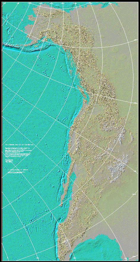
The North American Cordillera consists of an essentially continuous sequence of mountain ranges that form the western "backbone" of North America and continue on through Central America and South America. From north to south, this sequence of overlapping and parallel ranges begins with the Alaska Range and the Brooks Range in Alaska and run through the Yukon into British Columbia. The main belt of the Rocky Mountains along with the parallel Coast Ranges of mountains and islands continue through British Columbia and Vancouver Island. In the United States, the Cordillera branches to include the Rockies, the Sierra Nevada and Cascade Range, plus the Coast ranges of Washington, Oregon, and California.
To the south in Mexico, the Cordillera continues through the Sierra Madre Occidental and Oriental and Baja California peninsula. The Cordillera continues on through the mountain ranges of Central America and becomes the Andes Mountains of South America. In addition, the range can possibly be followed through the arcuate South Georgia Ridge across the Southern Ocean to the mountains of Graham Land on the Antarctic Peninsula. The Cordillera are the eastern half of the Pacific Ring of fire, which continues around the Pacific Ocean via Kamchatka, Japan, and Indonesia to Polynesia.
Files available for downloading:
View description of the map and the various methods of obtaining a plot file: ReadMe.txt (3 kb)
Download the 30" X 54" compressed rtl plot file of Open-File Report 98-140: namc.rtl.Z (39 MB compressed, 48.1 uncompressed)
Download the 30" X 54" EPS plot file of Open-File Report 98-140: namc.ps.Z (19.2 MB compressed, 94.6 uncompressed)
Download the 30" X 54" compressed Postscript plot file of Open-File Report 98-140, optimized for the HP2500CP plotter: namc2500.ps.Z (19.2 MB compressed, 94.6 uncompressed)
Download the 30" X 54" compressed ARC/INFO graphics meta-file of Open-File Report 98-140: namc.gra.Z (14.4 MB compressed, 61.4 MB uncompressed)
Download the 30" X 54" PDF version of Open-File Report 98-140: namc.pdf (7 MB)
For questions about the content of this report, contact Ralph Hagerud
Download a free copy of Adobe Reader.
For additional information:
Contact Information, Western Region Geology and Geophysics Science Center—Seattle
U.S. Geological Survey
Dept. Earth & Space Sciences
University of Washington, Box 351310
Seattle, WA 98195-1310
http://geomaps.wr.usgs.gov/

![]() U.S. Department of the Interior |
U.S. Geological Survey
U.S. Department of the Interior |
U.S. Geological Survey
URL: http://pubsdata.usgs.gov/pubs/of/1998/of98-140/index.html
Page Contact Information: GS Pubs Web Contact
Page Last Modified: Wednesday, 07-Dec-2016 16:47:58 EST