
Eric T. Sundquist
Robert F. Stallard
Norman B. Bliss
Helaine W. Markewich
Jennifer W. Harden
Milan J. Pavich
Walter E. Dean, Jr.
Understanding the carbon cycle is one of the most difficult challenges facing scientists who study the global environment. Lack of understanding of global carbon cycling is perhaps best illustrated by our inability to balance the present-day global CO2 budget. The amount of CO2 produced by burning fossil fuels and by deforestation appears to exceed the amount accumulating in the atmosphere and oceans. The carbon needed to balance the CO2 budget (the so-called "missing" carbon) is probably absorbed by land plants and ultimately deposited in soils and sediments. Increasing evidence points toward the importance of these terrestrial processes in northern temperate latitudes. Thus, efforts to balance the global CO2 budget focus particular attention on terrestrial carbon uptake in our own North American "backyard."
The USGS Mississippi Basin Carbon Project conducts research on the carbon budget in soils and sediments of the Mississippi River basin. The project focuses on the effects of land-use change on carbon storage and transport, nutrient cycles, and erosion and sedimentation throughout the Mississippi River Basin. Particular emphasis is placed on understanding the interactions among changes in erosion, sedimentation, and soil dynamics. The project includes spatial analysis of a wide variety of geographic data sets, estimation of whole-basin and sub-basin carbon and sediment budgets, development and implementation of terrestrial carbon-cycle models, and site-specific field studies of relevant processes. The USGS views this project as a "flagship" effort to demonstrate its capabilities to address the importance of the land surface to biogeochemical problems such as the global carbon budget.
Two hypotheses are being examined: (1) that carbon burial in terrestrial environments is accelerated by human influences on erosion and sediment deposition; and (2) that significant amounts of carbon are fixed from the atmosphere and supplied to sites of enhanced erosion and deposition, and to soils and sediments enriched by modifications of hydrologic systems and nutrient supplies. Study of these hypotheses is inherently historical, requiring mass balance estimates over time scales ranging from specific flood events to millennia. Similarly, the project requires consideration of a broad range of spatial scales. At the hillslope and small watershed scale, field studies are conducted to understand the processes that control local carbon erosion, transport, and accumulation. Results of these studies are integrated with data that are more readily applied over larger areas (for example, digital elevation models, inventories of dams and reservoirs, records of land use and land cover, fluvial discharge records, and soil and climate databases). This integration is being prototyped in several river sub-basins and will ultimately extend to characterization of relevant properties of the land surface over the whole basin. Modeling is inherent in every aspect of the project, both as a tool for understanding at discrete spatial and temporal scales, and as a method for integrating mass-balance calculations over time and space. To assure that our work is always guided by the need to extrapolate beyond field and sub-basin scales, we include whole-basin and global analyses even in the early stages of the project.
This science plan is intended to serve as a rationale and guide for project participants and as a source of information about the project for managers and potential collaborators. The activities described in this plan will be carried to a level of detail that depends on funding, the project lifetime, and the development of arrangements for collaboration and review by non-USGS scientists. Essential goals of the project are testing the two central hypotheses, estimating whole-basin carbon budgets, and linking these estimates to the global CO2 budget. Studies of carbon, sediment, and nutrient budgets in the Mississippi Basin will also provide valuable information relevant to many other problems associated with human land use. Agricultural productivity is threatened by increasing erosion and declining fertility of soils. Erosion and sedimentation are primary concerns in the management of water supplies and quality. Natural organic compounds play a critical role in the transport and storage of contaminants in waters and sediments. Carbon compounds account for most of the oxygen depletion associated with anoxia and eutrophication in lakes, streams, and coastal waters. An improved understanding of interactions between changes in the land surface and changes in the carbon cycle is essential to predicting and coping with global environmental change.
Humans have influenced many aspects of the Earth-surface environment and have markedly altered the biogeochemical and physical cycling of many materials. The Mississippi Basin Carbon Project (MBCP) of the U.S. Geological Survey (USGS) is an effort to examine interactions among some of the most profound human effects on the land surface. Humans have fundamentally changed the global carbon cycle by burning fossil fuels and by modifying a significant fraction of the world’s photosynthetic production for forestry and agriculture. Human activities have also radically transformed the land surface itself by converting large areas for human use and by drastically altering the transport of sediments and nutrients across the land and to the oceans. Interactions among these changes in the land surface and carbon cycle are central to many global environmental problems.
Human influences on the carbon cycle and on the nature of the land surface are inherently interrelated. One of the most fundamental connections is through climate. The relationships between global climate and atmospheric carbon dioxide (CO2) are a worldwide public concern and a principal issue in global environmental policy deliberations. There is a broad consensus among climate scientists that global warming and changes in rainfall patterns will result from the enhanced greenhouse effect of increasing atmospheric CO2 levels, augmented by the effects of increasing concentrations of other trace gases including methane (CH4) and carbon monoxide (CO) (IPCC, 1996). Although the principal source of anthropogenic CO2 is the burning of fossil fuels, atmospheric concentrations of CO2, CH4, and CO are significantly influenced by human alterations of the land surface. In turn, changes in atmospheric chemistry are thought to influence carbon cycling and other processes on the land surface through a complex system of climatic and biogeochemical feedbacks.
Fluxes and transformations of terrestrial carbon are also critical aspects of other global problems associated with human land use. On a global scale agricultural productivity is threatened by increasing erosion and declining fertility of soils, which comprise the largest carbon reservoir on the land surface. Natural organic compounds play a critical role in the transport and storage of contaminants in waters and sediments. Carbon compounds account for most of the oxygen depletion associated with anoxia and eutrophication in lakes, streams, and coastal waters. An improved understanding of interactions between changes in the land surface and changes in the global carbon cycle is essential to predicting and coping with global environmental change.
The need for this improved understanding is perhaps best illustrated by our inability to balance the present-day global CO2 budget. The amount of CO2 produced by burning fossil fuels and changing land use (especially by deforestation) appears to exceed the amount accumulating in the atmosphere and oceans. The carbon needed to balance the CO2 budget (sometimes termed the "missing" carbon, amounting to about 1 to 2 x 10⁹ tonnes yr-1) is probably absorbed by land plants and ultimately deposited in soils or sediments. Increasing evidence points toward carbon absorbed on land in the Northern Hemisphere. However, the specific identities of the needed CO2 sinks have not yet been documented (IPCC, 1996). Thus, efforts to balance the global CO2 budget focus particular attention on the terrestrial and coastal components of the global carbon cycle, and especially on the behavior of these components in our own North American "backyard."
The net carbon budget of land plants and soils has been a subject of intense debate and study for decades within the CO2 research community (see, for example, Bolin and Eriksson, 1959). Questions persist about the balance of effects of deforestation and reforestation, the extent of fertilization due to increased atmospheric CO2 concentrations, the response of soils to cultivation, and the influence of enhanced nutrient levels derived from wastes, rainfall, and chemical fertilizers. Possible carbon sinks can be calculated, but none have been directly observed that can account for the imbalance in the global CO2 budget. New perspectives are needed to advance our understanding of carbon on the land surface.
In their summary of the effects of human activities on sediment yields of North American rivers, Meade and others (1990) observed that agricultural land use typically accelerates erosion 10- to 100-fold, and that "ninety percent of the sediment presently being eroded off the land surface of the conterminous United States is being stored somewhere in the river systems between the uplands and the sea." Stallard (1995a) calculated that this storage amounts to about 3 x 10⁹ tonnes of sediment within the conterminous United States and perhaps 30 x 109 tonnes globally. Much of this sediment is stored in channels, behind dams, as alluvium, and as colluvium near sites of erosion. If this sediment contains 1.5% carbon (Stallard, in press), this would be a carbon sink amounting to 0.45x10⁹ tonnes yr-1. Although this calculation is a crude approximation, it illustrates that significant quantities of organic carbon are buried in sediments influenced by human activities. The burial of this carbon does not in itself imply a net removal of CO2 from the atmosphere. However, it points toward the potential for a significant and demonstrable net CO2 flux caused by the effects of human land use on the interactions among terrestrial erosion, sedimentation, and soil development.
Soil erosion has an enormous impact on the balance between carbon inputs and losses in agroecosystems. Erosion appears to be particularly significant in the loss of organic matter from soils that have been cultivated for a period of decades (Wander and Traina, 1996). Although soil conservation practices may greatly reduce erosion, soil organic matter inputs are concentrated at the soil surface, and hence eroded materials may be enriched in carbon (Rasmussen and Collins, 1991). Most models of soil organic carbon (SOC) dynamics have not considered the effects of erosion or sediment deposition on carbon storage. These effects may occur not only through removal and transport of soil organic matter, but also because erosion associated with tillage repeatedly renews the substrates for soil organic matter formation. In most areas, the formation of soil organic matter occurs more rapidly in relatively fresh substrates (Schlesinger, 1986).
Previous studies of the movement of sediment and carbon across landscapes have emphasized either small upland watersheds or continent-to-ocean transfer. Measurement of carbon and sediment fluxes has been included in some studies of small watersheds, such as the USGS Water, Energy, and Biogeochemical Budget (WEBB) sites and the National Science Foundation (NSF) Long-Term Ecological Research (LTER) sites. Unfortunately, few if any of these sites are representative of terrain subject to agriculture or other intensive human modifications. Several syntheses have examined carbon and sediment fluxes in the discharge of relatively large rivers (Meybeck, 1982; Ittekkot and Laane, 1991; Degens, 1982) and continental contributions to the global marine carbon budget (Sarmiento and Sundquist, 1992). However, these studies have not addressed the importance of the central feature of terrestrial sediment transport: that vast quantities of sediment are stored on land before getting to the ocean. A few previous studies have examined the potential for significant carbon deposition in terrestrial sediments (Mulholland, 1981; Mulholland and Elwood, 1982; Kempe, 1984). Although these studies suggested global alluvial deposition of up to 11 x 109 tonnes C yr-1 (Mulholland, 1981), they did not attempt an assessment of relative rates of deposition and oxidation in both soils and sediments. Stallard (in press) attempted to bridge this gap using an ensemble of plausible sediment and soil scenarios to estimate rates of carbon burial on land. Rates of carbon burial between 0.6 and 1.5 x 10⁹ tonnes C yr-1 appear to be entirely plausible, with about half being derived from upland erosion and half from autochthonous production in reservoirs, lakes, and agricultural wetlands. Moreover, most of this carbon burial results from human activities and occurs in northern temperate latitudes (Figure 1). Stallard (in press) suggested that these calculations suggest a plausible contribution to the so-called "missing" carbon.
By investigating these influences on carbon in soils and sediments of the Mississippi Basin, we hope to take a significant step toward understanding the global significance of human effects on terrestrial carbon cycling.
The Mississippi River is the largest North American river. Its basin (an area of 3.3 x 10⁶ km2) encompasses a remarkable range of variety in climate, vegetation, land use, and agriculture. The basin is well studied and includes areas that typify vast regions of the Earth’s surface that have undergone human development. By examining a variety of spatial scales, including the whole basin, we anticipate identifying those aspects of environmental change that have particularly large effects on carbon, nutrient, and sediment cycles. By exploiting the dense network of USGS stream gages, the availability of complete Geographic Information System (GIS) and Digital Elevation Model (DEM) coverage, and the large extant data bases assembled by the USGS and other Federal and state agencies, we are uniquely able to study the relationships affecting carbon in soils and terrestrial sediments over a globally significant region.
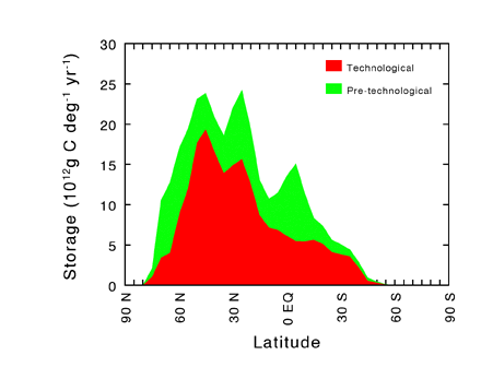 Figure 1 Latitudinal distribution of terrestrial sedimentary carbon sinks, showing both pre-technological sinks and those attributed to human land use. Calculated by Stallard (in press) for a single scenario in which enhanced carbon burial totals approximately 1 x 10¹⁵ g C yr-1 (or 1 x 10⁹ tonnes C yr-1). |
Based on the background information discussed above, we hypothesize that the rate of carbon burial in terrestrial depositional environments is enhanced by human activities. We suggest that accelerated erosion and deposition are accompanied by enhanced formation of soil organic matter on fresh substrates, including cultivated soils; and that the addition of nutrients from fertilizers, municipal wastes, and atmospheric deposition also contributes to the acceleration of carbon removal from the atmosphere and accumulation in terrestrial soils and sediments. We will pursue these ideas by investigating two core hypotheses:
Our consideration of these hypotheses is directed toward determining estimates of carbon fluxes that can be related to the global carbon budget. Our approach is guided by the fact that the present-day global carbon budget — including the problem of the global CO2 budget imbalance — is inherently historical. Although present-day industrial CO2 emissions and atmospheric CO2 increases can be documented on an annual basis, the other major terms in the annual CO2 budget (the terms for ocean uptake and effects of human land use) necessarily require historical information. These terms cannot be measured directly because they represent small net differences between large and uncertain "natural" carbon sources and sinks that have been perturbed by human activities. Estimates of these differences are derived from modeling the time-dependent effects of human influences. Estimates of annual ocean uptake (e.g., Siegenthaler and Sarmiento, 1993) are derived from time-dependent model calculations of oceanic CO2 dissolution and mixing for the period of historically increasing atmospheric CO2 concentrations. Likewise, calculation of annual land-use effects (e.g., Houghton and others, 1987) is based on time-dependent integration of historical sequences of carbon sources and sinks associated with areas of disturbance and recovery.
In a directly analogous manner, a historical approach is required to document the importance of terrestrial erosion, sedimentation, and soil development to the annual carbon budget. This approach emphasizes the application of time-dependent models rather than direct determination of large-scale annual fluxes. These models must make judicious use of available data and must be developed from careful field study of the processes that control the effects of human activities on the allocation of carbon in soils and sediments. Accordingly, our studies require the integration of modeling with extensive data analysis and field observations.
It is beyond our capabilities to account for all terrestrial carbon reservoirs and fluxes in the Mississippi basin. We will develop estimates of the amount of carbon stored in soils and sediments. We will model the historical evolution of that amount through time and, in so doing, we will calculate fluxes. Although we recognize that the Mississippi basin cannot be extrapolated to the world, we believe that the basin is diverse enough to provide a basis for estimating effects of human activities over broad areas of the northern hemisphere. These calculations will be directly relevant to global carbon budget estimates, but great care will be required in applying our work to specific carbon budget contexts. One such context is the "missing" terrestrial carbon sink that has been inferred from the imbalance among global CO2 budget terms. Some of these terms, particularly those relating to forests and soils, have varied in both definition and magnitude in recent studies (compare, for example, the CO2 budget summaries on p. 13 of IPCC, 1990, and p. 79 of IPCC, 1996). Application of our calculations to this budget context will demand very specific comparison to the treatment of soil carbon in budget terms defined elsewhere. Although previous treatments have not explicitly included significant carbon fluxes associated with erosion and deposition on land, some of these fluxes may have been encompassed implicitly in existing budget terms which include estimates of soil organic carbon depletion and recovery. Our contribution in this context will be to distinguish carbon fluxes representing net atmospheric exchange from those associated with erosion and sediment transport. This effort will require a careful, geographically explicit comparison of our own calculations with existing budget estimates. And because the unknown terrestrial sink is calculated as a residual of inherently historical terms, any attempt to identify it must incorporate documentation of its historical as well as present-day behavior.
Two time scales of particular importance to understanding the terrestrial carbon cycle in the Mississippi basin are (1) the period of widespread historical human influence (roughly, the last 200 years) and (2) the period of the most recent transition from glacial to interglacial climatic conditions (about 5,000 to 15,000 years ago). From the ice-core record of historical atmospheric CO2 concentrations, we know that changes in the land surface must have influenced atmospheric chemistry well before the Industrial Revolution (Neftel and others, 1985). An understanding of these historical changes is critical to understanding both the effects of early human land use and the nature of the carbon cycle before more pronounced human disturbance. Likewise, the most recent deglaciation was accompanied by conspicuous but poorly understood changes in terrestrial carbon cycling (Harden and others, 1992; Sundquist, 1993). An understanding of these deglacial changes will provide information needed to anticipate effects of potential future climate change. Together, studies of deglacial and historical changes will address the very important question of whether the carbon cycle was at a steady state prior to human influence. Model projections of future atmospheric CO2 concentrations are all based on the assumption of a prior steady state. Although this assumption is probably reasonable for short-term forecasts, it must be more carefully evaluated when applied to long-term simulations of effects of erosion, deposition, and soil carbon formation. Our focus on these processes requires consideration of time scales longer than those usually considered in forecasting anthropogenic CO2 perturbations.
The MBCP integrates simultaneous studies at three spatial scales which we define as the field scale, the sub-basin scale, and the whole-basin scale.
At the field scale, our focus is to identify and understand key processes. Current carbon budget calculations for changes in land use do not include explicit treatment of terrestrial sedimentation and erosion. Although the calculations may implicitly reflect partial effects of these processes, estimating their contribution to the CO2 budget imbalance is extremely difficult. Likewise, current models of carbon cycling in forests and soils cannot easily accommodate transport of carbon across the land surface. Because such models must be used to reconstruct past changes, and ultimately to anticipate effects of future human activities, they must be based on a thorough understanding of all the processes that control carbon cycling on the land surface. Empirical, non-mechanistic models, even though they may accurately resolve the present-day carbon budgets, may not be capable of forecasting the future magnitude of the Northern Hemisphere terrestrial sink.
Process-based models will require site-specific verification of the importance of enhanced erosion and sedimentation to soil development and other forms of terrestrial carbon accumulation. Fortunately, some of the most important questions concerning these processes are accessible to study at the hillslope and small watershed scale of typical field studies. For example, how much eroded soil and carbon are redeposited locally? How does cultivation affect the accumulation of carbon in soils? What is the stability of soil-derived carbon in alluvium and colluvium? What features of the land surface – both disturbed and undisturbed – control rates of carbon accumulation? Questions such as these can be studied by careful monitoring and sampling of hillslope transects, small basins, and chronosequences. Other questions, such as those concerning the relative importance of soil-derived and aquatic sources of carbon in sediments, can be addressed by analysis of sediment cores taken from lakes, reservoirs, and wetlands. A variety of chemical, isotopic, and monitoring techniques are available to help us to answer these questions.
Intensive field studies can only assess a small fraction of the basin area. Applying field process studies to larger spatial scales is not simply a matter of summation of results from the field scale. Results of these studies must be integrated with a wide range of data that are more readily applied to larger areas: GIS, DEM, inventories of dams and reservoirs, records of land use and land cover, fluvial discharge records, and soil and climate databases. Application of these data to basin-wide carbon budgets requires the extensive use of models. Modeling is inherent in every aspect of the MBCP. From the examination of site-specific processes to the integration of basin-wide information, modeling serves a wide variety of purposes. It is used as a teaching and learning tool by researchers during the course of ongoing investigation and hypothesis-testing. It is used for diagnostic purposes in analysis and synthesis of data and interrelationships. It serves prognostic needs for projection of trends (present, past, or future) that cannot be directly measured. Finally, modeling can provide the critical connections between our work in the Mississippi basin and that of the larger research community engaged in studies of carbon cycling and environmental change at the global scale.
We are prototyping this integration of data and models in the sub-basins of the Yazoo, Nishnabotna, and South Platte Rivers. Another prototype study is sited on the coastal plain and delta in Louisiana, and additional sites will be selected to extend our set of prototype basins across both north-south and east-west gradients in the basin. A primary advantage of such prototyping is that the integration design can be checked by detailed examination of data and field sites. Integration over the whole basin, while more important to the global carbon budget, must be based on methods and assumptions that are best evaluated at smaller scales. To assure that our work is always guided by the need to extrapolate beyond the field and sub-basin scales, we include whole-basin analyses even in the early stages of the project. Building on the analysis of sediment storage in the conterminous United States by Meade and others (1990), Stallard (in press) has developed a preliminary global synthesis of sediment and carbon storage by reservoirs, lakes, alluviation, and colluviation. These estimates provide an initial guide to estimating values for the Mississippi Basin as a whole. Upon completion of the project, our synthesis of data and models will include basin-wide maps of sediment and carbon erosion and storage, chemical weathering yields, and nutrient loadings. These maps, when integrated over area using GIS techniques, will provide a direct test of the working hypothesis that sedimentation on land is storing significant quantities of carbon. Effects of this carbon storage on the atmospheric CO2 budget can be estimated only by time-dependent modeling. GIS techniques can be used to simulate a range of plausible historical changes in the geographical distribution of basin properties. The combining of these GIS scenarios with time-dependent models will provide a test of the hypothesis that buried carbon is being replaced by new carbon fixation.
To the maximum extent possible, we will make use of existing land-surface models of sediment transport, erosion, and soil development. Likewise, existing carbon-cycle and ecological models will be exploited. However, these disparate land-surface, ecological, and carbon-cycle models are very difficult to link in a manner appropriate to our study. For example, models depicting carbon-cycle effects of human land use are often based on ecological land-surface classification schemes that ignore geomorphologic features that might control erosion and sedimentation. Soil development models must be adapted to accommodate erosion and sediment transport. Erosion models and sedimentation models must be linked together in a consistent manner that accommodates carbon transport and burial. Models of basin- or regional-scale processes must be linked to the global-scale carbon budget. Models of present-day processes must be linked to time-dependent simulations of historical trends. Therefore our efforts must emphasize integration across spatial and temporal scales and among various disciplinary perspectives. At the site-specific scale, we will examine ways to adapt soil development models to incorporate sediment and carbon transport to and from the site. At the basin scale, we will develop links between models of sediment transport and models of carbon transport. We will work with ecologists and land-use specialists to adapt models of historical land use to accommodate effects on erosion and carbon transport across the land surface. To test hypothesized implications of our work for the global carbon budget, we will implement a global carbon-cycle model linking terrestrial and marine carbon fluxes and reservoirs. The nature of the carbon budget problem requires us to encompass spatial scales ranging from site-specific to global, and temporal scales ranging from single floods to millennia.
The central concept essential to this degree of integration among diverse data and models is conservation of mass. This requirement is obviously inherent in our goal of defining carbon budgets, and would seem to be inherent in any model of material transport and transformation. However, the specific nature of our requirement is not fulfilled in existing models, many of which were developed for purposes that did not require mass balance in the sense needed for our studies. For example, models of soil erosion generally do not account for removal of material in both dissolved and particulate form, and do not incorporate sediment deposition. Models of sediment deposition often ignore colluvial deposition, and models of carbon transformation in sediments do not address sediments subject to repeated episodes of flooding and emergence. Models of soil development usually do not include erosive loss or depositional gain of material. To adapt and integrate these models and their concepts for our purposes, it is critical that we extend the requirement for conservation of mass across the landscape and through time.
The MBCP will take advantage of a wide array of relevant spatial data available for the Mississippi River basin. These data are summarized in Table 1.
In addition to the spatial data summarized in Table 1, we will make use of available data on sediment transport and composition within the Mississippi River basin. A particularly promising source of data is the Mississippi River Project, a USGS study of mass transport along the mainstem of the Mississippi River during the years 1987 to 1992 (Meade, 1995). This study provided an exceptional description of carbon transport at the largest spatial scale within the basin. The project focused on obtaining representative samples of water and sediment from various cross sections of the mainstem and mouths of the larger tributaries. The most sophisticated non-contaminating depth-integrated sampling technologies were used (Meade and Stevens, 1990, Moody and Meade, 1994, Rees and others, 1991). Much of the focus was on the transport of contaminants and how these were partitioned among dissolved, colloidal, and particulate forms. This required characterization of the natural organics within the river system (Leenheer, 1991, 1994). The distribution and transport of organic contaminants could then be characterized in terms of the movement of dissolved and particulate organic carbon (Barber and others, 1995). Data have been compiled (Barber and others, 1995b, Leenheer and others, 1995 a,b) and are available to the Mississippi Basin Carbon Project. In addition to these data, representative subsamples of suspended sediment (frozen) and organic isolates (freeze dried) are available to this project for use in further characterization.
The available data described above will require substantial integration and analysis before application to the research objectives of the MBCP. Understanding the transport of water, sediment, and carbon across the land will require a thorough characterization of many aspects of the land surface. Before this characterization can be accomplished, the available spatial data must be closely scrutinized and evaluated for accuracy and internal consistency. Methods must be developed to adapt and integrate data that were collected and compiled for a wide range of purposes. For example, the assignment of watershed boundaries must take into account the delineation of USGS hydrologic unit codes (HUC’s), topographic information from DEM’s, and the river-reach files of the Environmental Protection Agency (EPA). Because the required characterization of the land surface will have utility for a wide range of purposes in addition to our own, we expect that our integration and analysis of land-surface data (utilizing GIS techniques) will be a very important byproduct of the MBCP.
| Type of data | Source of data | Comments |
|---|---|---|
| Topography | USGS 3-arc-second Digital Elevation Model (DEM) (USGS, 1990); will be reprojected and
resampled to 100-meter spacing in an equal-area map projection.
For detailed study areas, USGS 30-meter resolution (7-1/2 minute quadrangle series) and in some cases 10-meter resolution DEM data will be used. |
Several additional data layers will be derived from the elevation data, including slope, aspect, slope-length, and curvature. Automated and semi-automated techniques will be used to compute stream networks, flow accumulation, stream order, drainage basins, and soil moisture accumulation indexes. |
| Soil | State Soil Geographic (STATSGO) data base, developed by the U.S. Department of Agriculture, Natural Resources Conservation Service (NRCS) (NRCS, 1994). Compiled at a scale of 1:250,000; map units consist of soil associations. Refinements will be made by linking the component soil series data in STATSGO to the soil characterization records for pedons that are selected as representative for those series by the NRCS. A more detailed data base of soil climate for the 1961-1990 base period will be formed using methods developed by William Waltman at the NRCS center in Lincoln, NE (Waltman and others, 1997). | Separate maps and data layers will be developed for factors significant for modeling carbon flux, erosion, and sedimentation, including soil depth, texture, clay content, particle size distribution, bulk density, organic carbon content, hydrologic properties, erodibility, acidity, salinity, cation exchange capacity (nutrient holding capability), slope, parent material, water table, flooding frequency, drainage, hydric classification, soil taxonomic classification, soil moisture regime, and soil temperature regime. |
| Land cover and land use | Conterminous U.S. Land
Cover Characteristics Data Set 1990 Prototype, developed by the USGS EROS Data Center
(Loveland, et.al, 1991; Eidenshink, 1992.
A more detailed view, but with less information about seasonal vegetation changes, will be derived from a USGS data set interpreted and digitized from aerial photography, primarily from the mid-1970s (Anderson, et.al., 1976). |
Uses a classification of composite greenness index images derived from Advanced Very High Resolution Radiometer (AVHRR) satellite data. The data have been resampled to 1-km cells in an equal area map projection, and are available for the United States portion of the Mississippi Basin study area. |
| Land use time series | The National Resources Inventory (Wolman, 1986; USDA, 1995) provides a time series of land use and conservation-related data for the years 1982, 1987, and 1992. | A statistical data base; can be linked to spatial data bases using county, major land resource area, and hydrologic unit. |
| Hydrologic units | 8-digit Hydrologic Unit Codes (HUC) (Seaber and others, 1987). | Will be used for initial analyses of relationships between landscape and stream and sediment characteristics |
| Reservoirs | Reservoir Sedimentation Survey Information System (RESIS), obtained from the NRCS, (Steffen, 1996); supplemented by information from the National Inventory of Dams (FEMA and ACE, 1993). | See text in following section. |
| Stream gage data | A vector geographic information system will be used to manipulate data on stream networks and to link to information from USGS stream gages. | Drainage basins above stream gages will be delineated from the DEM data. |
| Climate | GEWEX/GCIP climate data (e.g., Rea and Cederstrand, 1994). | Mississippi basin is designated as a site for intensive climate monitoring as part of the GEWEX/GCIP program. |
| Other imagery | Selected Landsat Thematic Mapper images, developed by the North American Land Characterization Program and available from the EROS Data Center. | May be used for detailed study areas, primarily to give a visual perspective on the landscape. |
Our analysis will require integration of spatial data with a diverse array of information. The complexity of this task can be illustrated by considering the kinds of data integration needed to examine the hypothesis that significant quantities of carbon are being deposited and stored as sediment on the landscape. These include:
Further data integration and analysis will be necessary to examine the hypothesis that eroded soil organic carbon is replaced by newly fixed organic carbon. For example, the data sets and analyses discussed above can be organized with GIS methods and used as inputs to models of the dynamics of soil organic carbon on the landscape. An initial estimate of the quantity of soil organic carbon can be made from the STATSGO data base (Bliss, et.al, 1995), augmented with forest litter data from the U.S. Forest Service. In this manner the soil organic carbon content at various depths can be estimated, reflecting the NRCS program of sampling and database building over the last 40 years. To develop a more dynamic view of soil organic carbon, the data can be structured for use in time-dependent models. Spatial data sets for the factors that influence inputs to the soil organic carbon pool; including type of vegetation, soil properties, climate, and management practices; can be interpreted and adapted using GIS techniques to estimate the spatial distribution of rates of organic carbon input for soil models. The same data sets can also be used to develop relationships for estimating model soil organic carbon decomposition rates. The data can be evaluated in additional ways to provide inputs to models that simulate runoff, erosion, and sediment transport and deposition. The understanding of key processes will be strengthened by field research, and both spatial and field data will be used to parameterize and calibrate a variety of models, as discussed in the following sections.
Site-specific, process-related studies are an essential component of the MBCP because we hypothesize that some important processes have been overlooked in the assessment of terrestrial carbon cycling. Objectives of our field studies include (1) identification of the major accumulation, decomposition, transport, and denudation processes for soil, sediment, and carbon; (2) identification of key processes that may be of critical value in extrapolating to basin and global scales, (3) field testing of the hypothesis that the deposition of carbon in lowland soils and sediments is enhanced by human acceleration of erosion and modifications of hydrologic systems and nutrient supplies; and (4) field testing of the hypothesis that soil organic carbon eroded from uplands is being replaced by accumulation of new organic carbon at rates sufficient to maintain significant soil organic carbon storage. The project will require integration of field data with many types of models and data characterizing the land surface at a variety of spatial and temporal scales.
The inherently historical calculations required to analyze the carbon budget, the time scales of soil disturbance and redistribution, and the time-integrating character of the soil and sediment record, require that our focus be on carbon in organic matter that resists decomposition for at least several years. SOC has been variously characterized as a mixture of labile (very young; mineralized within a year after deposition), intermediate (older; mineralized on time scales of years to decades), and nearly passive (old; mineralized over centuries or longer) pools of carbon (e.g., O’Brien, 1984; Gregorich and others, 1996; Parton and others, 1993; Trumbore and others, 1990; van Veen and Paul, 1981). Our focus emphasizes the need to understand controls on and responses of the intermediate SOC pool, which has been shown to comprise a large fraction of SOC in the upper horizons of a wide range of soil types (Trumbore and others, 1996, and references therein). This pool, however, cannot be extracted or measured directly. Its size and turnover can only be assessed indirectly by a combination of fractionation and isotopic techniques (e.g., Trumbore and others, 1996) We will apply these techniques to an understanding of the dynamic behavior of the intermediate SOC pool at our field sites.
Given this focus, our field studies will be guided by the principal terms in an idealized mass-balance equation for the intermediate SOC pool in soils or sediments:
| dC/dt = I - L = Iprod + Ideposit - Ldecomp - Lfire- Leros - Ldoc | (1) |
where dC/dt is the rate of change of soil or sediment intermediate SOC content, I is total input of intermediate SOC per unit time, L is total loss of intermediate SOC per unit time, Iprod is input by new production, Ideposit is input by sedimentation, Ldecomp is loss due to decomposition, Lfire is loss due to fire, Leros is loss by erosion, and Ldoc is loss by transport of dissolved organic carbon.
Iprod values for the intermediate SOC pool cannot be derived simply from estimates of net primary production (NPP), crop residue yield, or other measures of vegetative production, most of which mineralizes rapidly. We will infer estimates by a variety of indirect means, including studies of post-harvest crop residues (Buyanovsky and Wagner, 1986; Gregorich and others, 1996) and comparisons between relatively undisturbed soils and cultivated soils with known land-use histories (e.g., Harden and others, submitted). We will emphasize studies of the carbon isotopic composition of SOC, including the use of radiocarbon measurements (e.g., Trumbore and others, 1990) and the exploitation of isotopic shifts associated with cultivation (e.g., Harrison and others, 1995; Gregorich and others, 1996). Wherever possible, we will use recent (0 to 200 yr) soil chronosequences where the upper soil horizons are well characterized (e.g., Harden and others, submitted). All of these indirect methods will rely extensively on the application of soil carbon models such as CENTURY (Parton and others, 1993; Schimel and others, 1994; see below), which can be linked to models of vegetative production such as CERES-Maize (Jones and Kiniry, 1986).
Ideposit values can be obtained from studies of organic carbon movement along erosion-to-deposition pathways and from inventories of organic carbon in floodplain, terrace, alluvial, colluvial, lake and reservoir sediments. Because much of the sediment eroded from soils may be redeposited locally, our field studies will include mass balance calculations from elevation, soil, and sedimentation surveys in small drainage and plot experiments such as those conducted at USDA-ARS stations (e.g., Liu and others, 1997; McGregor and others, 1969). Other field studies will focus on carbon deposition on floodplains and in wetlands, lakes, and reservoirs.
Ldecomp estimates can be derived using a variety of analytical and sampling techniques, including chronosequences of recent deposits (Harden and others, submitted) and comparison of recently (1960-1980) archived soil samples to newly sampled soil profiles (Trumbore and others, 1990). Where these methods are not feasible in areas of intensive land disturbance, estimation of Ldecomp for the intermediate SOC pools will require alternative techniques, including soil-gas flux measurements in combination with 13C and 14C analyses of respired CO2 (Townsend and others, 1995), and comparison of pairs of older archived (1950's or older) and newly sampled soil profiles for estimation of the amounts of nearly passive pools of SOC (Trumbore and others, 1996). Incubation experiments will also be conducted to estimate intermediate SOC decomposition rates.
Estimates of Lfire require values for fire frequency and effectiveness of burn, and can be derived from historic and tree-ring records.
The Leros and Ideposit terms contribute to a sediment mass balance that requires quantification of the masses of soil eroded and redeposited on the landscape, and of the relation of the intermediate SOC pool to the mobile soil mass. Field study of these terms will require the careful selection of soil catenas (transects across hillslope gradients) where we can evaluate the mass and volume of mobile soil. We will need to account for the spatial relations of soil as it is redistributed on hillslope positions by transport. Initially, we may not be able to quantify the transport processes, although some estimates may be available from elevation remeasurement surveys and from ongoing erosion studies, such as those used in development of soil loss equations and in hillslope/watershed programs such as the Water Erosion Prediction Project (WEPP) (McGregor and others, 1969; Liu and others, 1997; Baffaut and others, 1997; Ascough and others, 1997; Nearing and others, 1989).
Ldoc values can be determined at the field scale by direct measurements of DOC in runoff and in soil water leaching out of the rooting zone. There are a number of uncertainties associated with such measurements related to stability of the organic fractions sampled and the large degree of spatial variation in soil water chemistry.
A variety of field and laboratory methods will be deployed to characterize organic carbon in soils and sediments, and to elucidate the factors that control carbon transfer to and from the intermediate SOC pool. These methods will vary depending on the environment under study. Field methods for our upland soil studies will include (1) excavation of soil profiles; (2) soil gas flux measurement and soil gas sampling for isotopic measurements to assess decomposition of the intermediate SOC pool; (3) monitoring of soil temperature and moisture; and (4) measurement of sediment transport and deposition. Laboratory methods will include (1) SOC fractionation procedures (Parton and others, 1993; Trumbore and others, 1990; Wander and Traina, 1996); (2) incubation studies (for example Fyles and McGill, 1986) to test decomposition rates defined by field respiration and carbon fractionation procedures; (3) carbon and nutrient chemistry of bulk soil and of soil fractions; (4) isotope chemistry (Townsend and others, 1995; Trumbore and others, 1990; Balesdent and others, 1987) on selected samples; (5) particle size and inorganic geochemistry on selected samples, and (6) bulk density on every soil horizon.
Sediments on floodplains -- including marshes, swamps, rice paddies and peat bogs -- differ in many ways from typical soils. Sediments from these environments will be sampled for total organic carbon, isotopic (137Cs, 14C, 13C), and microfossil (pollen and phytolith) analyses. These analyses will be used to establish variations in carbon accumulation through time, and to distinguish among different sources of carbon accumulation in each environment.
Techniques employed for study of lake and reservoir sediments differ somewhat from those used in upland soil or marsh/swamp environments. Although lakes do not contribute significantly to the terrestrial sediment carbon budget, we will use studies of lake sediments to infer environmental effects on the carbon budget of the surrounding land surface, and to test methods that will be applied to reservoir sediments. Lakes in Wisconsin, Minnesota, and the Dakotas have a wide range of chemical (acid to alkaline), biological (oligotrophic to eutrophic) and physical (open and closed basin) attributes; therefore, they are ideal localities to compare and contrast effects of anthropogenic and natural environmental/climatic change on sediment records of carbon cycling. Sediments will be analyzed for bulk chemistry (including organic and inorganic carbon content), age determination by radionuclide analyses (210Pb and 137Cs), and stable isotope ratios in a number of constituents. Through these analyses we intend to relate changes in land use and environmental conditions to rates of organic carbon accumulation. Our studies will focus initially on oligotrophic and eutrophic settings of acid and alkaline lakes in northern and southern Wisconsin. This comparative approach will increase our understanding of how land-use and other environmental changes have affected the accumulation and cycling of carbon. Initial results suggest that recent trends in carbon accumulation, bulk isotopic characteristics, and onset of varve sedimentation correspond temporally to documented changes in environmental conditions (i.e., land use, cultural eutrophication, anoxia) and climatic fluctuations (i.e. duration of lake ice cover, temperature, amount of rainfall, atmospheric circulation patterns, etc.). Data from sediments collected in Minnesota lakes indicate past changes in hydrologic regime (open to closed basin) and migration of the forest/prairie boundary. Our ongoing experience in studying lake sediments will be applied to studies in reservoirs, where more significant amounts of carbon may be buried as a result of human activities.
We will use measurements of the isotope 10Be to provide indices of the state of soils with respect to erosion and deposition. 10Be enters the soil from the atmosphere in rainfall. It is particle-reactive and is adsorbed most strongly by the inorganic fine fraction, particularly manganese and iron-oxyhydroxide complexes. 10Be varies vertically in pedons, with the highest concentrations in the Bt horizons. In a minimally eroded soil developed in Peoria loess (a common substrate in the north-central part of the Mississippi basin and along the Mississippi River as far south as Louisiana), we can expect the depth-profile of 10Be concentrations to mimic the clay distribution. Redeposition of eroded soil, particularly the clay fraction, can be correlated with 10Be concentration of sediments (Valette-Silver and others, 1986; Brown and others, 1988; Pavich and others, 1993). In a small basin, it may be possible to construct a mass balance of the 10Be removed from eroded sites and redeposited at accretionary sites downslope. In part, the success of this approach will depend upon our ability to accurately measure soil accretion in field characterization of pedons. Trimble (1975) presented methods for estimating the volumetric changes associated with soil redistribution on an erosional landscape. To complete the mass balance in a small basin, we will need accurate measurements of volume and bulk density changes during soil erosion, as well as an estimate of the soil exported from the basin.
Soil catenas will provide contrasting sites for 10Be analysis. To simplify the calculation of mass balance estimates, each catena must have a uniform parent material. The Peoria loess has been analyzed at several Mississippi basin sites for 10Be. The analyses show that there is a background of inherited 10Be on the unweathered, carbonate-rich loess. Typically the background concentration is significantly less than the concentrations measured in soil horizons. On a uniform parent material, a relatively simple model of 10Be mass balance can be constructed. The mass balance in atom cm-2 for any pedon in the catena can be expressed by the equation:
| 10Betotal = 10Beinh + 10Beatm - 10Beerode + 10Beaccrt | (2) |
where: 10Beinh is the background inventory of 10Be (inherited from the previous history of silt and clay particles now in the loess); 10Beatm is the cumulative deposition from the atmosphere at the site; 10Beerode is the cumulative erosional loss on particles removed from the top of the pedon; and 10Beaccrt is the cumulative amount accreted in the pedon on particles transported from upslope. In the case of a soil that has not been altered by erosion or accretion since the end of Peoria loess deposition (ca. 12ka), the total should equal the inherited amount plus the cumulative atmospheric deposition. The catena must contain at least one site which represents the pre-agricultural, uneroded soil to serve as a control for comparison of eroded and accreted sites. In such a pedon, we can determine the vertical sequence of horizon boundaries, bulk densities, texture, bulk chemistry, carbon chemistry, and isotope chemistry.
The use of 10Be to identify eroded or aggraded soil in the catena will depend upon our ability to identify and sample soil horizons. The 10Be concentration distribution in a disturbed profile may be distinctly different from the distribution in the uneroded control site. Concentration variations may help us to identify the thickness of soil eroded or aggraded relative to the control site. Bulk density measurements will also enable us to calculate the inventories (atom cm-2) of 10Be in eroded, aggraded, and control sites. Once we have an understanding of the vertical dimensions of erosion and aggradation, sampling can be simplified to obtain inventories from cores of pedons, significantly reducing the number of 10Be analyses. Future studies may augment these analyses using measurement of 137Cs and 7Be.
Criteria for field site selection will be a critical aspect of this research. Ideally, the number of detailed study sites would be sufficient to characterize the major processes controlling carbon cycling. However, the resources of the MBCP are not sufficient to assess carbon dynamics in all the major environments of the Mississippi basin. Study sites will therefore be distributed to enable us to characterize processes of carbon accumulation at typical and extreme values along a climatic continuum. Within those sites we will evaluate factors in the carbon mass balance (equation 1) along slope transects or catenas (Schimel and others,1985) that represent major soil mapping units of the area. Wherever possible, study sites will include existing relevant databases such as soil and sediment records and historic records of land use practices, as well as ongoing erosion/runoff studies, such as the runoff plots of the Agricultural Research Service (ARS) and sites included in the WEPP (Ascough and others, 1997; Nearing and others, 1989). Another important criterion for site preference will be the availability of archived soil samples. To the maximum extent possible, we will locate field study sites in the sub-basins selected as prototypes for the MBCP. Figure 2 shows the locations of selected and potential field sites and sub-basins.
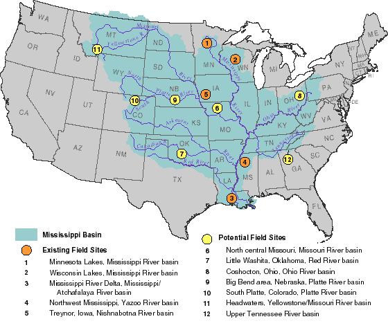 Figure 2 Map showing the Mississippi River Basin and existing and potential MBCP field sites. |
By building on existing models, we can take advantage of a wide range of excellent tools developed to simulate many of the fundamental processes controlling carbon transport across the landscape. The available models most directly useful to our project are those that simulate landscape hydrology, erosion, sediment transport and deposition, soil development, and global carbon cycling. Rather than attempting a complete review of existing models here, we describe prominent examples of each type of model and discuss their benefits and limitations in relation to the Mississippi Basin Carbon Project.
A characterization of surface runoff is the first step in simulating transport of any substance across the land surface. A characterization of soil moisture is also essential to modeling many of the processes that control SOC development and turnover. Simulations of surface runoff and soil moisture are accomplished by landscape hydrology models such as TOPMODEL (Beven and Kirkby, 1979; Beven and others, 1995). This model simulates the distribution of recharge, soil water throughflow, and runoff using a hydrological similarity index based entirely on topographic and soil properties. The principal benefit of this approach to our work is that it provides an efficient means of simulating both soil moisture (needed to simulate soil development) and overland flow (needed to simulate erosion and transport) based on available topographic and soil data. In principle this approach is scalable to the entire Mississippi basin; in practice the application of this approach to large regions and agricultural settings will require careful adaptation of methods heretofore applied usually to small forested watersheds. For example, TOPMODEL does not include erosion, deposition or sediment transport. We will require a modeling framework that accounts for these processes in a way that assures conservation of water, sediment, and carbon. Additional limitations may arise from the limited data available for calibration of extreme events, which dominate erosion and transport of sediments across the land surface.
Because of their practical importance to agriculture, empirical approaches dominate existing models of erosion. The most widely used erosion model is the Universal Soil Loss Equation (USLE) (Wischmeier and Smith, 1965, 1978; Wolman, 1986). This equation is simply
| A = RK(LS)CP | (3) |
where A is the rate of erosion in mass per unit area and time; andR,K,(LS),C, andPare empirical terms representing the influences of rainfall, soil erodibility, slope (length and steepness), cropping practices, and erosion control measures, respectively. The usefulness of this approach is apparent in its derivation from numerous studies of rates of erosion in farm fields throughout the Mississippi basin (Wischmeier and Smith, 1965, 1978) and its continuing extension to a wide range of settings and applications (see, for example, Ferreira and others, 1995; Toy and Osterkamp, 1995). Its relevance to our project is enhanced by its separation of terms representing natural influences (the productRK(LS), sometimes termed "inherent erosion potential") from those representing effects of land use (CandP). However, values used for the empirical terms may be somewhat subjective, and the equation may not be suitable for areas subject to wind erosion, ephemeral gully erosion, snowmelt, or rangeland use. Moreover, extension of the model to soil organic matter will require an assessment of the extent to which organic matter is selectively eroded.
An independent approach to the assessment of human effects on erosion is the concept of "steady-state" erosion. This concept refers to the assumption of balance between sediment production (erosion) and transport. Clearly human activities have disrupted any such balance that may have existed in the Mississippi basin. However, recent assessments (Gaillardet and others, 1995; Stallard, 1995a,b) have suggested that pre-existing steady-state erosion rates may be estimated by modeling chemical weathering rates implied by present-day transport of certain dissolved weathering products. This approach can be used to test other estimates of human effects, and to further develop theories linking chemical and physical erosion.
Our requirement for mass balance across the landscape implies a need to directly link erosion models to models of sediment transport and deposition. One approach to this problem is represented by the Simulation for Water Resources in Rural Basins (SWRRB) and the Hydrologic Unit Model of the United States (HUMUS) (Williams and others, 1985). These interrelated models link sediment yield from a Modified Universal Soil Loss Equation (MUSLE) to sediment deposition in ponds, reservoirs, channels, and floodplains. The MUSLE is identical in form to the USLE except that the term for rainfall is derived from an explicit hydrologic model. Thus, this approach demonstrates the possibility of linking models of erosion, sediment transport and deposition, and landscape hydrology. However, its sedimentation algorithms depend on information about travel times and particle-size distributions that will be difficult to estimate, and extending this model to carbon will require treatment of differential transport and degradation.
To successfully model the mass balance of sediments transported across the land surface, we require an approach that can be applied to all of our basic spatial scales: field site, sub-basin, and full Mississippi basin. Testing at the sub-basin scale will serve as a basis for extension to the whole basin and for identification of key problems requiring model refinement in studies of processes at field sites.
Many of the limitations of available models, for our purposes, lie in their inability to address conservation of mass across the landscape. Our choice of existing models will therefore be guided by their compatibility with GIS techniques and suitability to spatial integration. A landscape hydrology model is the first logical step in developing the unique integrative capability we require. We will begin with an approach similar to that of TOPMODEL, developing similarity indices from appropriately scaled digital elevation models (DEM’s) and digital soil maps. Particular attention will be devoted to problems of extending this approach to large agricultural basins and to extreme flood events. The resulting landscape representation will provide a platform for parallel development of modeling capabilities to simulate (1) material transport, (2) soil development, and (3) contributions to carbon cycling. Indices of landscape and soil characteristics will be incorporated into models of material transport, as exemplified by the soil erodibility and topography terms in the USLE. Other models – such as the SWRRB/HUMUS -- will then be used to link sediment transport and deposition directly to calculations of erosion. Thus, we will have a framework of models of runoff, erosion, and sedimentation which can be used to develop estimates of carbon mass balance across the landscape. The final stage of this effort will involve model assessment of the historical effects of land use; and comparison of "natural" erosion estimates from this approach to steady-state erosion estimates.‹
Our modeling of material transport will be combined with estimates of the concentration of organic carbon in runoff, suspended material, and sediments to provide a basis for modeling carbon erosion, transport, and deposition across the land surface. We will focus initially on testing the approach of Stallard (in press), who considered riverine suspended material to be comprised of autochthonous (i.e., produced by aquatic organisms) and allochthonous (i.e., soil-derived) components. Following Stallard, we hypothesize that each of these two components can be associated with a characteristic organic carbon concentration, and that the concentration of autochthonous suspended material is relatively constant. These hypothesized conditions imply an inverse relationship between the concentration of total suspended material and the fraction of organic carbon in the suspended load. This relationship appears to be reasonable for suspended sediment in large rivers (Stallard, in press); we will further test it using data from streams and rivers in the Mississippi basin. We will also examine ways of improving this simple approach by exploring other systematic relationships, such as those between autochthonous production and nutrient loads, and between suspended particle size and organic carbon concentration.
Our carbon modeling effort must include major emphasis on the processes that control carbon accumulation in soils. Many field and experimental studies have shown that, for given land use and landscape characteristics, the amount of organic carbon in soils tends toward an equilibrium or steady-state value. The trend toward equilibrium can often be approximated by an equation for the first-order kinetics of change in soil organic carbon:
| dC/dt = I - L = I - kC | (4) |
where C is the soil organic carbon content, t is time, I is the rate of addition of organic carbon to the system, and k is a constant that determines the proportion of organic carbon removed from the system in unit time (see, for example, Jenny and others, 1949; Olson, 1963; Schlesinger, 1977; Greenland, 1995). In relatively undisturbed soils, the addition rate (I) reflects primarily thein situproduction of SOC from plant litter and roots, while carbon loss (L) occurs primarily throughin situdecomposition, loss as DOC, and, in some cases, burning. At equilibrium or steady state, the inputs of C are balanced by outputs (I = L = kC), and there is no net change in the amount of stored C (dC/dt = 0). A positive sign for the term (I - kC) indicates that the soil is a carbon sink (sequestration) and a negative sign indicates that the soil is a carbon source.
Equation (4) can be used to illustrate some of the basic principles and difficulties in applying soil carbon models to areas where cultivation has caused erosion and deposition to contribute significantly to the carbon mass balance. For example, consider an undisturbed soil at steady state in whichin situproduction is the primary source of SOC andin situdecomposition is the primary removal mechanism. Then, following equations (1) and (4),
| I = L = kC = Iprod= Ldecomp | (5) |
The SOC production rate (I) in agricultural soils includes not only in situ production from plant litter and roots, but also crop residue returned to the soil, sediment deposition, addition of compost and farmyard manure, dung from grazing cattle, and any other source of carbon added to the soil (Lal and others, 1995). The loss rate (L) represents erosion as well as the removal processes that affect undisturbed soils. In simplest form, these alterations can be represented by,
in areas of erosion,
| I = Iprod+ Iadded | (6) |
| L = Ldecomp+ Leros= kC + Leros | (7) |
and in areas of deposition,
| I = Iprod+ Iadded + Idep | (8) |
| L = kC = Ldecomp | (9) |
where Iadded and Idep are the inputs of carbon added to the soil by crop management and deposition, respectively; and Leros is the loss of carbon due to erosion. Thus, cultivation introduces factors that will certainly alter the steady state toward which relatively undisturbed soils might be expected to evolve. In fact, because carbon inputs and losses (particularly sedimentation and erosion) are much more likely to be episodic rather than continuous in cultivated soils, the attainment of "steady state" may have little practical meaning. Comparison of equation (5) to equations (6) - (9) suggests some important non-steady-state generalizations. In areas of erosion, the carbon content (C) and rate of decomposition (kC) will tend to decrease due to the loss of SOC to erosion (Leros). In these areas the likelihood of SOC being oxidized in situ is reduced because some of it is eroded before it can be oxidized. This effect may be somewhat offset by oxidation during transport, but most eroded SOC is probably redeposited before it can be oxidized. In areas of deposition, the carbon content (C) and rate of decomposition (kC) will likely rise in response to the increased carbon input from sedimentation (Idep). However, accretion tends to favor SOC preservation, and areas of deposition also tend to have higher soil moisture contents (or may even be under water), further enhancing the probability of preservation. Thus the probability of in situ decomposition (represented by k) in areas of deposition is almost certainly less than that in areas of erosion. In other words, the simple equations above suggest that SOC that is eroded and redeposited is less likely to be decomposed than SOC that remains in upland soils. Moreover, the equations indicate that any enhancement of soil carbon inputs by cultivation will tend to accelerate the delivery of SOC to sites of both erosion and sedimentation, thereby accelerating the likelihood of preservation.
Of course the modeling of agricultural soils is not this simple. Cultivation usually decreases rates of addition of organic matter to the soil; however, soil amendments which lead to greater crop yields, larger root systems, and more crop residues will tend to enhance levels of soil organic matter (Greenland, 1995). The magnitude of the decomposition constant k depends on climate, geomorphic setting, the composition of the soil organic matter (particularly the lignin content), intrinsic soil properties (such as acidity, texture, and clay content), land use, and soil and crop management practices. For a given geographic area, the magnitude of k can be expected to be relatively low for natural ecosystems and for agricultural soils subject to soil and crop management practices that involve prudent off-farm inputs, conservation tillage, crop residue return, and other soil restorative measures. On the other hand, relatively high values of k can be expected for soils subject to deforestation, biomass burning, plow-based tillage, and other cropping systems that exacerbate soil degradative processes. Enhancements of k values may also occur in cases of expansion of agricultural activities to marginal or ecologically-sensitive areas (Lal and others, 1995).
Fortunately, a number of existing soil organic carbon models have been applied to a wide range of soils and land-use settings (e.g., Jenkinson, 1990; Parton and others, 1987; Li and others, 1994). For example, the CENTURY model (Parton and others, 1994) has been applied to a particularly broad range of soil responses to observed and potential human influences, including cropping practices, fertilizer addition, tillage, and climate change (Parton and others., 1996). Such models typically subdivide soil organic carbon into various fractions with different susceptibilities to decomposition. This scheme is convenient for us because we are concerned only with the fraction of SOC that decomposes over time scales greater than a few years. However, an important limitation is that the modeled soil organic fractions cannot be physically or chemically separated by generally accepted methods; thus these models must be highly parameterized for particular settings. Another specific problem for our purposes is that the models do not generally accommodate erosion or deposition in a manner that assures conservation of mass across the landscape. Even model implementations that include explicit erosion effects (e.g., Voroney and others, 1981; Barnwell and others, 1992; Donigian and others, 1995) do not account for the fate of carbon removed from sites of erosion.
To complete our assessment of carbon mass balance across the landscape, we will need to link models of soil carbon dynamics to models of landscape hydrology and material transport. For example, we can adapt the CENTURY model through spatial allocation of parameters consistent with TOPMODEL indices and with the soil erosion and deposition simulations. In this manner, CENTURY can become one component in a landscape model with the capacity to accommodate carbon mass balance across the landscape. The time-dependent characteristics of CENTURY also enable us to simulate historical effects of changing land use and soil development accompanied by erosion and deposition.
Much of the debate concerning the modern global carbon dioxide budget focuses on the results of models of terrestrial carbon cycling. A variety of models have been applied to the diagnosis of historical effects of land use (Houghton and others, 1987) and the forecasting of future terrestrial carbon budgets (Melillo and others, 1993, 1995). These issues are fundamental motivations for our project and we must be able to relate our results to those of other approaches to terrestrial carbon modeling. Unfortunately none of the existing terrestrial carbon cycle models addresses the effects of carbon transport across the land surface. Moreover, very few models have examined the linkages among terrestrial carbon cycling, river fluxes to the oceans, and marine carbon cycling. One such model is that of Sundquist (1990), which has been used to simulate the contribution of river fluxes to the annual carbon dioxide budget (Sarmiento and Sundquist, 1992). Although this model has been used to model past carbon cycle changes and interactions between terrestrial and marine CO2 budgets, it must be substantially updated if it is to be used as a link between USGS studies of the Mississippi basin and models of global carbon cycling. We will use this model as a starting point for linking our studies of carbon in the Mississippi basin to estimates of effects on the global carbon dioxide budget. We will focus on placing our "first cut" whole-basin carbon budget in the context of a global carbon cycle model. This task will require rectifying the land-surface characterizations of our whole-basin analysis with those used in ecological models of terrestrial carbon cycling.
The reconstruction of predevelopmental conditions (and comparison with the present) is central to our hypothesis that significant amounts of additional carbon are buried during the deposition of sediments in terrestrial environments, and that this burial has occurred in large part because of human acceleration of erosion and modifications of soil and hydrologic systems and nutrient supplies. Moreover, we must estimate historical trends in our calculation of carbon budget terms associated with these processes. We have no direct measurement of the past behavior of these processes, and for many environments, we have no direct measurements of the present. Thus, we must develop and compare parallel syntheses of the present and the past based on our integration of databases and models. There are virtually no precedents for this kind of approach to terrestrial carbon cycle modeling. Thus our approach must be open and flexible enough to adapt to new ideas and to unexpected opportunities and stumbling blocks. We will begin with the following strategies:
An element essential to the success of the MBCP will be continued emphasis on cooperation and collaboration with active research programs within the USGS and other Federally and internationally funded global change research programs. The need for cooperation and collaboration is twofold:
Perhaps the project’s most conspicuous opportunities for dialog and active collaboration are in our plans to make extensive use of existing models. We have initiated contacts with groups involved in the development of well-known models of landscape hydrology, soil carbon, and erosion. Although these groups are working on TOPMODEL, CENTURY, and WEPP, respectively, we will maintain active communications with groups working on other models. For example, to better appraise the relationship between our calculations and those used in the IPCC assessments of the global CO2 budget, we have initiated a collaboration with terrestrial ecologists who are modeling the effects of land use on global carbon fluxes. Our modeling efforts will require substantial innovation, especially in linkages among different kinds of models, and we will benefit from the knowledge and advice of collaborators working with a diversity of models. We will also devote particular attention to model linkage efforts such as the USGS Modular Modeling System (Leavesley and others, 1996).
Collaborative opportunities exist in every aspect of our planned activities. For example, we have initiated formal cooperative arrangements with the ARS for field work at several sites of ongoing erosion research. Our characterization of the land surface will benefit from interaction with the activities of the Global Energy and Water Cycle Experiment Continental Scale International Project (GEWEX/GCIP) of the World Climate Research Program. To the extent possible, we will also structure our efforts so that they can take advantage of improved data products expected in the near future. These will include new 30-m Landsat TM-derived land cover data, high-resolution data expected in association with NOAA’s ETA Mesoscale Model, and data products anticipated from NASA’s Mission to Planet Earth.
Another beneficial form of collaboration is the opportunity for regular scientific review of our activities. We have initiated a proposal review process for consideration of limited USGS funding for external research directed at targeted problems beyond our own expertise. We will also establish mechanisms for routine independent review of both specific project activities and overall MBCP progress and plans.
This science plan will be distributed to appropriate USGS scientists and managers and to collaborators and potential collaborators within and outside the USGS. In the final year of the project, a USGS circular or symposium volume will be prepared summarizing results.
A major product of the MBCP will be the delineation of individual drainage basins in a self-consistent manner. We will begin by registering the basins associated with NID and RESIS data within the Yazoo, Nishnabotna, and South Platte prototype study areas. We will also register Hydrologic Unit Codes and RESIS basins for the entire Mississippi drainage area. Basin characterization will begin with verification of RESIS database attributes for the prototype basins. We will extend this process of registration and verification to other basins and ultimately to the entire Mississippi River drainage. A long-term goal is the merging of the delineated basin data, using GIS techniques, with the wide variety of other available spatial data summarized in Table 1.
Initial products will include open file reports summarizing (1) the field measurements and techniques used in MBCP research on upland soil processes; and (2) the objectives, basis for site selection, site descriptions, core descriptions, methods description and documentation , data tables, and references for all delta sites. We will also produce an abstract describing the development of soil incubation techniques using field CO2 flux and carbon isotopes as tracers, and a fact sheet summarizing the interdivisional, interagency, and interorganizational activities of the MBCP in the southernmost part of the Mississippi Basin.
Subsequent products are somewhat conjectural, but we anticipate abstracts and/or reports on the following topics:
A future fact sheet will summarize the interdivisional, interagency, and interorganizational activites of the MBCP in the northcentral part of the Mississippi Basin. Summary journal articles will be published to summarize and compare data from field studies in upland soil sites, Delta and lowland sites, and lakes and reservoirs.
An open-file report will present a "first-cut" carbon budget for the Mississippi Basin. Initial model development will include testing of landscape indices (such as those used in TOPMODEL) as indicators of areas of erosion and deposition in selected basins, and upgrading of code for existing USGS global CO2 models. Subsequently, we anticipate developing links between landscape indices and soil model parameters such as those used in CENTURY. Global modeling will be extended to include explicit treatment of land surface disturbance and soil development, and land characterization schemes will be developed to bridge the gap between ecological carbon cycle models and those developed by this project. Results of these modeling activities will be published in journal articles.
Databases developed for this project will be available to the public by anonymous ftp, either by direct access to the server or through the world wide web. Various products will be designed to aid in visualization of the results.
Available data will include:
A set of briefing materials will be prepared and made available to program managers and members of the science management team. These materials will be used to explain basic project goals and strategies to both technical and nontechnical audiences. The briefing materials will also be incorporated into a MBCP "home page" which will be accessible to the public. A more general "carbon cycle home page" will be established to provide a broad range of structured carbon cycle data for those seeking background information regarding the MBCP and related research. All briefing materials and web sites will be updated as the project progresses.
Alt, D.F., 1995, Hydrologic records of the United States Water Year 1994: U.S. Geological Survey State Water Report, CD-ROM.
Alt, D.F., 1994, Hydrologic records of the United States Water Years 1990, 1991, 1992 and 1993: U.S. Geological Survey State Water Report, CD-ROM.
Anderson, J.R., Hardy, E.E., Roach, J.T., and Witmer, R.E., 1976, A land use and land cover classification system for use with remote sensor data: U.S. Geological Survey Professional Paper 964, 28 p.
Ascough II, J.C., Baffaut, C., Nearing, M.A., and Liu, B.Y., 1997, The WEPP watershed model: I. Hydrology and erosion: Trans. of ASAE, v. 40, p. 921-933.
Baffaut, C., Nearing,, M.A., Ascough, J.C. II, and Liu, B.Y., 1997, The WEPP watershed model: II. Sensitivity analysis and discretization on small watersheds: Trans. of ASAE, v. 40, p. 935-943.
Balesdent, J., Mariotti, A., and Guillet, B., 1987, Natural 13C abundance as a tracer for studies of soil organic matter dynamics: Soil Biology and Biochemistry, v. 19, p. 25-30.
Barber, L.B., II, Leenheer, J.A., Pereira, W.E., and others, 1995a, in Meade, R.H., editor, Contaminants in the Mississippi River, 1987-92, U.S. Geological Survey Circular 1133, p. 115-134, 140 Pages.
Barber, L.B., II, Leenheer, J.A., Tabor, C.F., and others, 1995b, Organic compounds and sewage-derived compounds, in Moody, J.A., editor, Chemical Data for Water Samples Collected During Four Upriver Cruises on the Mississippi River Between New Orleans, Louisiana, and Minneapolis, Minnesota, May 1990-April 1992, U.S. Geological Survey, Open-File Report 94-523, p. 211-297.
Barnwell, T.O., Jr., Jackson, R.B., IV, and Elliott, E.T., Burke, I.C., Cole, C.V., Paustian, K., Paul, E.A., Donigian, A.S., Patwardhan, A.S., Rowell, A.S., and Weinrich, K., 1992, An approach to assessment of management impacts on agricultural soil carbon: Water, Air, and Soil Pollution, v. 64, p. 423-435.
Beven, K.J., and Kirkby, M.J., 1979, A physically based variable contributing area model of basin hydrology: Hydrology Science Bulletin, v. 24, no. 1, p. 43-69.
Beven, K.J., Lamb, R., Quinn, P.F., Romanowicz, R., and Freer, J., 1995, TOPMODEL, in Singh, V.P., ed., Computer models of watershed hydrology: Highlands Ranch, Colo., Water Resources Publications, p. 627-668.
Bliss, N.B., Waltman, S.W., and Petersen, G.W., 1995, Preparing a soil carbon inventory for the United States using geographic information systems, in Lal, R., Kimble, J., Levine, E., and Stewart, B.A., eds., Advances in soil sciences, soils and global change: Boca Raton, Fla., CRC Press, Lewis Publishers, p. 275-295.
Bolin, B., and Eriksson, E., 1959, Changes in the carbon dioxide content of the atmosphere and sea due to fossil fuel combustion, in Bolin, B., ed., The atmosphere and the sea in motion: New York, the Rockefeller Institute Press, p. 130-142.
Brown, L., Pavich, M.J., Hickman, R.E., Klein, J., and Middleton, R., 1988, Erosion of the eastern United States observed with 10Be: Earth Surface Processes and Landforms, v. 13, p. 441-457.
Buyanovsky, G.A., and Wagner, G.H., 1986, Post-harvest residue input to cropland: Plant and Soil, v. 93, p. 57-65.
Degens, E.T., ed., 1982, Transport of carbon and minerals in major world rivers: Mitteilungen aus dem Geologisch-Palaontologischen Institut der Universitat Hamburg, Heft 52, 766 p.
Dendy, F.E., Champion, W.A., and Wilson, R.B., 1973, Reservoir sedimentation surveys in the United States, in Ackermann, W.C., White, G.F., and Worthington, E.B., eds., Man-Made Lakes: Their Problems and Environmental Effects: Washington, D.C., American Geophysical Union, Geophysical Monograph 17, p. 349-357.
Donigian, A.S., Jr., Patwardhan, A. S., Jackson, R.B., IV, Barnwell, T.O., Weinrich, K.B., and Rowell, A.L., 1995, Modeling the impacts of agricultural management practices on soil carbon in the central U.S., in Lal, R., Kimble, J., Levine, E., and Stewart, B.A., eds., Soil management and greenhouse effect, Advances in soil science: Boca Raton, Fla., CRC Press, Lewis Publishers, p. 121-145.
Eidenshink, J.C., 1992, The 1990 conterminous U.S. AVHRR data set: Photogrammetric Engineering and Remote Sensing, v. 58, no. 6, p. 809-813.
FEMA (Federal Emergency Management Agency), and ACE (U.S. Army Corps of Engineers), 1993, Water Control Infrastructure: National Inventory of Dams 1992, Executive Summary, Technical Summary, CD-ROM.
Ferreira, V.A., Weesies, G.A., Yoder, D.C., Foster, G.R., and Renard, K.G., 1995, The site and condition specific nature of sensitivity analysis: Journal of Soil and Water Conservation, v. 50, p. 493-497.
Fyles, J.W., and McGill, W.B., 1986, Decomposition of boreal forest litters from central Alberta under laboratory conditions: Canadian Journal of Forest Research, v. 17, p. 109-113.
Gaillardet, J., Dupre, B., and Allegre, C.J., 1995, A global geochemical mass budget applied to the Congo Basin rivers: erosion rates and continental crust composition: Geochimica et Cosmochimica Acta, v. 59, no. 7, p. 3469-3485.
Greenland, D.J., 1995, Land use and soil carbon in different agroecological zones, in Lal, R., Kimble, J., Levine, E., and Stewart, B.A., eds., Soil management and greenhouse effect, Advances in Soil Science: Boca Raton, Fla., CRC Press, Lewis Publishers, p. 9-24.
Gregorich, E.G., Ellert, B.H., Drury, C.F., and Liang, B.C., 1996, Fertilization effects on soil organic matter turnover and corn residue C storage: Soil Science Society of America Journal, v. 60, p. 472-476.
Harden, J.W., Trumbore, S., and O'Neill, K.P., (submitted), A comparison of modeling and measurement approaches for determining soil carbon storage and turnover in grassland soils: Biogeochemistry.
Harden, J.W., Sundquist, E.T., Stallard, R.F., and Mark, R.K., 1992, Dynamics of soil carbon during deglaciation of the Laurentide ice sheet: Science, v. 258, p. 1921-1924.
Harrison, A.F., Howard, P.J.A., Howard, D M., Howard, D.C. and Hornung, M., 1995, Carbon storage in forest soils: Forestry, v. 68, p. 335-348.
Houghton, R.A., Boone, R.D., Fruci, J.R., Hobbie, J.E., Melillo, J.M., Palm, C.A., Peterson, B.J., Shaver, G.R., Woodwell, G.M., Moore, R., Skole, D.L., and Myers, N., 1987, The flux of carbon from terrestrial ecosystems to the atmosphere in 1980 due to changes in land use: geographic distribution of the global flux: Tellus, v. 39B, p. 122-139.
IPCC (Intergovernmental Panel on Climate Change), 1990, Climate Change – The IPCC Scientific Assessment: Cambridge, Cambridge University Press, 365 p.
IPCC (Intergovernmental Panel on Climate Change), 1996, Climate Change 1995 -- The Science of Climate Change: Cambridge, Cambridge University Press, 572 p.
Ittekkot, V., and Laane, R.W.P.M., 1991, Fate of riverine particulate organic matter, in Degens, E.T., Kempe, S., ad Richey, J.E., eds., Biogeochemistry of Major World Rivers: New York, John Wiley & Sons Ltd., p. 233-243.
Jenkinson, D.S., 1990, The trunover of organic carbon and nitrogen in soil: Philosophical Transactions of the Royal Society of London B, v. 329, p. 361-368.
Jenny, H., Gessel, S.P., Bingham, F.T., 1949, Comparative study of decomposition rates of organic matter in temperate and tropical regions: Soil Science, v. 68, p. 419.
Jones, C.A., and and Kiniry, J.R., eds., 1986, CERES-Maize: A Simulaton Model of Maize Growth and Development: College Station, TX, Texas A&M University Press, 194 p.
Kempe, S., 1984, Sinks of the anthropogenically enhanced carbon cycle in surface fresh waters: Journal of Geophysical Research, v. 89, p. 4657-4676.
Lal, R., Kimble, J., and Stewart, B.A., 1995, World soils as a source or sink for radiatively-active gases, in Lal, R., Kimble, J., Levine, E., and Stewart, B.A., eds., Soil management and greenhouse effect, Advances in soil science: Boca Raton, Fla., CRC Press, Lewis Publishers, p. 1-7.
Leavesley, G.H., Restrepo, P.J., Markstrom, S.L., Dixon, M., and Stannard, L.G., 1996, The Modular Modeling System (MMS): User’s Manual: U.S. Geological Survey, Open-File Report 96-151,
Leenheer, J.A., , 1991, Organic substance structures that facilitate contaminant transport and transformations in aquatic sediments, in Baker, R.A., editor, Organic Substances and Sediments in Water, Humics and Soils: Chelsea, Michigan, Lewis Publishers, p. 3-22.
Leenheer, J.A., 1994, Chemistry of dissolved organic matter in rivers, lakes, and reservoirs, in Baker, L.A., editor, Environmental Chemistry of Lakes and Reservoirs: Washington, D.C., American Chemical Society, Advances in Chemistry Series 237, p. 195-222.
Leenheer, J.A., Barber, L.B., Rostad, C.E., and others, 1995a, Data on natural organic substances in dissolved, colloidal, suspended-silt, and-clay and bed-sediment phases in the Mississippi River and some of its tributaries, U.S. Geological Survey, Water-Resources Investigations Report 94-4191, 47 pages.
Leenheer, J.A., Noyes, T.I., and Brown, P.A., 1995b, Data on natural organic substances in dissolved, colloidal, suspended-silt and -clay, and bed-sediment phases in the Mississippi River and some of its tributaries, 1987-90, U.S. Geological Survey, Water-Resources Investigations Report 93-4204, 71 pages.
Li, C., Frolking, S., and Harriss, R., 1994, Modeling carbon biogeochemistry in agricultural soils: Global Biogeochemical Cycles, v. 8, p. 237-254.
Liu, B.Y., Nearing, M.A., Baffaut, C., and Ascough, J.C. II,. 1997. The WEPP watershed model: III. Comparisons to measured data from small watersheds: Transactions of the ASAE, v. 40, p. 945-952.
Loveland, T.R., Merchant, J.W., Ohlen, D.O., and Brown, J.F., 1991, Development of a land-cover characteristics database for the conterminous U.S.: Photogrammetric Engineering and Remote Sensing, v. 57, no. 11, p. 1453-1463.
McGregor, K.D., Greer, J.D., Gurley, C.E., and Bolton, G.C., 1969, Runoff and sediment production from North Mississippi loessial soils: State College, Miss., Mississippi State University Agriculture Experiment Station, Bulletin 777, p. 3-30.
Meade, R.H., editor, 1995, Contaminants in the Mississippi River, 1987-92, U.S. Geological Survey Circular 1133, 140 Pages.
Meade, R.H., and Stevens, H.H., 1990, Strategies and equipment for sampling suspended sediment and associated toxic chemicals in large rivers - with emphasis on the Mississippi River: Science of the Total Environment, v. 97/98, p. 125-135.
Meade, R.H., Yuzyk, T.R., and Day, T.J., 1990, Movement and storage of sediment in rivers of the United States and Canada, in Wolman, M.G., and Riggs, H.C., eds., Surface Water Hydrology: Boulder, Colorado, Geological Society of America, The Geology of North America, v. O-1, p. 255-280.
Melillo, J.M., Borchers, J., Chaney, J., Fisher, H., and Fox, S., 1995, Vegetation/ecosystem modeling and analysis project: comparing biogeography and biogeochemistry models in a continent-scale study of terrestrial ecosystem responses to climate change and CO2 doubling : Global Biogeochemical Cycles, v. 9, no. 4, p. 407-437.
Melillo, J.M., McGuire, A.D., Kickligher, D.W., Moore, B., III, Vorosmarty, C.J., and Schloss, A.L., 1993, Global climate change and terrestrial net primary production: Nature, v. 363, p. 234-240.
Meybeck, M., 1982, Carbon, nitrogen, and phosphorus transport by world rivers: American Journal of Science, v. 287, p. 401-428.
Moody, J.A., and Meade, R.H., 1994, Evaluation of the method of collecting suspended sediment from large rivers by discharge-weighted pumping and separation by continuous-flow centrifugation: Hydrological Processes, v. 8, p. 513-530.
Mulholland, P.J., 1981, Deposition of riverborne organic carbon in floodplain wetlands and deltas, in Flux of Organic Carbon by Rivers to the Oceans, Report of a Workshop, Woods Hole, Massachusetts, September 21-25, 1980: U.S. Department of Energy CONF-8009140, p. 142-172.
Mulholland, P.J., and Elwood, J.W., 1982, The role of lake and reservoir sediments as sinks in the perturbed global carbon cycle: Tellus, v. 34, p. 490-499.
Nearing, M.A., Foster, G.R., Lane, L.J., and Finker, S.C., 1989, A process-based soil erosion model for USDA-water erosion prediction Project Technology: Transactions of the ASAE, v. 32, p. 1587-1593.
Neftel, A., Moor, E., Oeschger, H., Stauffer, B., 1985, Evidence from polar ice cores for the increase in atmospheric CO2 in the past two centuries: Nature, v. 315, p. 45-47.
NRCS, 1994, State soil geographic (STATSGO) database - date use information: Fort Worth, Tex., U.S. Department of Agriculture, Natural Resources Conservation Service, Miscellaneous publication number 1492 (revised edition), [variously paged] .
O'Brien, B.J., 1984, Soil organic carbon fluxes and turnover rates estimated from radiocarbon enrichments: Soil Biology and Biochemistry, v. 16, no. 2, p. 115-120.
Olson, J.E., 1963, Energy storage and the balance of producers and decomposers in ecological systems: Ecology, v. 44, p. 322-331.
Parton, W.J., Schimel, D.S., Cole, C.G., and Ojima, D.S., 1987, Analysis of factors controlling soil organic matter in Great Plains Grasslands: Soil Science Society of America Journal, v. 51, p. 1173-1179.
Parton, W.J., Schimel, D.S., and Ojima, D.S., 1994, Environmental change in grasslands: assessment using models: Climatic Change, v. 28, p. 111-141.
Parton, W.J., Ojima, D.S., and Schimel, D.S., 1996, Models to evaluate soil organic matter storage and dynamics, in Carter, M.R., and Stewart, B.A., eds., Structure and Organic Matter Storage in Agricultural Soils: New York, CRC Press, p. 421-448.
Parton, W., Scurlock, J.M.O., and Ojima, D.S., 1993, Observations and modeling of biomass and soil organic matter dynamics for the grassland biome worldwide: Global Biogeochemical Cycles, v. 7, p. 785-809.
Pavich, M.J., Brown, L., Harden, J.W., Klein, J., and Middleton, R., 1986, 10Be distribution in soils from Merced River terraces, California: Geochimica et Cosmochimica Acta, v. 50, p. 1727-1735.
Rasmussen, P.E., and Collins, H.P., 1991, Long-term impacts of tillage, fertilizer, and crop residue on soil organic matter in temperate semi-arid regions: Advances in Agronomy, v. 45, p. 93-134.
Rea, A., and Cederstrand, J.R., 1994, GCIP Reference Data Set (GREDS): U.S. Geological Survey Open-File Report 94-388, CD-ROM.
Rees, T.F., Leenheer, J.A., and Ranville, J.F., 1991, Use of a single-bowl continuous-flow centrifuge for de-watering suspended sediments - Effect on sediment physical and chemical characteristics: Hydrological Processes, v. 5, p. 20l-2l4.
Renwick, W.H., 1996, Continent-scale reservoir sedimentation patterns in the United States, in Walling, D.E., and Webb, B.W., eds., Erosion and sediment yield: Global and regional perspectives, July 15-19, 1996: Exeter, UK, International Association of Hydrological Sciences, IAHS Publication 236, p. 513-522.
Sarmiento, J.L., and Sundquist, E.T., 1992, Revised budget for the oceanic uptake of anthropogenic carbon dioxide: Nature, v. 356, p. 589-593.
Saucier, R.T., and Snead, J.I., 1989, Quaternary geology of the Lower Mississippi Valley: 2 sheets, Louisiana Geological Survey, Baton Rouge, Louisiana.
Schimel, D.S., Braswell, B.H., Holland, E.A., McKeown, R., Ojima, D.S., Pinter, T.H., Parton, W.J., and Townsend, A.R.,1994, Climatic, edaphic, and biotic controls over storage and turnover of carbon in soils: Global Biogeochemical Cycles, v. 8, no. 3, p. 279-294.
Schimel, D.S., Coleman, D.C., and Horton, K.A., 1985, Soil organic matter dynamics in paired rangeland and cropland toposequences in North Dakota: Geoderma, v. 36, p. 201-214.
Schlesinger, W.H., 1977, Carbon balance in terrestrial detritus: Ann. Rev. Ecol. Syst., v. 8, p. 51-81.
Schlesinger, W.H., 1986, Changes in soil carbon storage and associated properties with disturbance and recovery, in Trabalka, J.R., and Reichle, D.E., eds., The changing carbon cycle – a global analysis: New York, Springer-Verlag, p. 194-220.
Seaber, P., Kapinos, P., and Knapp, G., 1987, Hydrologic Unit Maps: U.S. Geological Survey Water-Supply Paper 2294, 63 p., folded map in pocket.
Siegenthaler, U., and Sarmiento, J.L., 1993, Atmospheric carbon dioxide and the ocean: Nature, v. 365, p. 119-125.
Stallard, R.F., 1995a, Tectonic, environmental, and human aspects of weathering and erosion: A global review using a steady-state perspective: Annual Review of Earth and Planetary Sciences, v. 12, p. 11-39.
Stallard, R.F., 1995b, Relating chemical and physical erosion, in White, A.F., and Brantley, S.L., eds., Chemical weathering rates of silicate minerals, Reviews in mineralogy, Volume 31: Washington, D.C., Mineralogical Society of America, p. 543-564.
Stallard, R.F., in press, Terrestrial sedimentation and the carbon cycle: Global Biogeochemical Cycles.
Steffen, Lyle J., 1996, A reservoir sedimentation survey information system - RESIS, in Proceedings of the Sixth Federal Interagency Sedimentation Conference, March 10-14, 1996, Las Vegas, Nev.: Sponsored by the Subcommittee on Sedimentation, Interagency Advisory Committee on Water Data, p. 29-37.
Sundquist, E.T., 1990, Long-term aspects of future atmospheric CO2 and sea-level changes, in Revelle, R., ed., Sea-level change: National Research Council Studies in Geophysics: Washington, D.C., National Academy Press, p. 193-207.
Sundquist, E.T., 1993, The global carbon dioxide budget: Science, v. 259, p. 934-941.
Townsend, A.R., Vitousek, P.M., and Trumbore, S.E., 1995, Soil and organic matter dynamics along gradients of temperature and land-use: Ecology, v. 76, p. 721-733.
Toy, T.J., and Osterkamp, W.R., 1995, The applicability of RUSLE to geomorphic studies: Journal of Soil and Water Conservation, v. 50, p. 498-503.
Trimble, S.W., and Lund, S.W., 1982, Soil conservaton and the reduction of erosion and sedimentation in the Coon Creek basin, Wisconsin: U.S. Geological Survey Professional Paper 1234, 35 p.
Trimble, S.W., 1983, A sediment budget for Coon Creek basin in the driftless area, Wisconsin, 1853-1977: American Journal of Science, v. 283, p. 454-474.
Trimble, S.W., 1975, A volumetric estimate of man-induced soil erosion on the southern Piedmont plateau: Agricultural Research Service Publication, ARS-S-40, p. 142-154.
Trumbore, S.E., Bonani, G., and Wolfi, W., 1990, The rates of carbon cycling in several soils from AMS 14C measurements of fractionated soil organic matter, in Bouwman, A.F., ed., Soils and the greenhouse effect: West Sussex, England, John Wiley and Sons Ltd., p. 407-414.
Trumbore, S.E., Chadwick, O.A., and Amundson, R., 1996, Rapid exchange of C between soils and atmospheric carbon dioxide driven by temperature change: Science, v. 272, p. 393-396.
USDA (U.S. Department of Agriculture), 1995, 1992 National Resource Inventory, CD-ROM.
USGS (U.S. Geological Survey), 1990, Digital elevation models, National Mapping Program Technical Instructions, Data Users Guide 5, 2nd Printing (Revised): Reston, Va. (http://edcwww/glis/hyper/guide/1_dgr_dem)
Valette-Silver, J.N., Brown, L., Pavich, M.J., Klein, J., and Middleton, R., 1986, Detection of erosion events using 10Be profiles: Example of the impact of agriculture on soil erosion in the Chesapeake Bay area: Earth and Planetary Science Letters, v. 80, p. 82-90.
Van Veen, J.A., and Paul, E.A., 1981, Organic carbon dynamics in grassland soils, 1. Background information and computer simulation: Canadian Journal of Soil Science, v. 61, p. 185-201.
Voroney, R.P., Van Veen, J.A., and Paul, E.A., 1981, Organic C dynamics in grassland soils. 2. Model validation and simulation of the long-term effects of cultivation and rainfall erosion: Canadian Journal of Soil Science, v. 61, p. 211-224.
Waltman, W.J., Ciolkosz, E.G., Mausbach, M., Svoboda, MD., Miller, D.A., and Kolb, P.J., 1997, Soil Climate Regimes of Pennsylvania: University Park, Pennsylvania State Agricultural Experiment Station, Bulletin 873, 235 p.
Wander, M.M., and Traina, S.J., 1996, Organic matter fractions from organically and conventionally managed soils: I. Carbon and nitrogen distribution: Soil Science Society America Journal, v. 60, p. 1081-1087.
Williams, J.R., Nick, A.D., and Arnold, J.G., 1985, Simulator for water resources in rural basins: Journal of Hydraulic Engineering, v. 111, no. 6, p. 970-986.
Wischmeier, W.H., and Smith, D.D., 1978, Predicting rainfall erosion losses: A guide for conservation planning: U.S. Department of Agricultural Handbook 537: Washington, D.C., U.S. Government Printing Office, 58 p.
Wischmeier, W.H., and Smith, D.D., 1965, Predicting rainfall-erosion losses from cropland east of the Rocky Mountains: U.S. Department of Agricultural Handbook 282: Washington, D.C., U.S. Government Printing Office, 47 p.
Wolman, G.M, 1986, Soil conservation: Assessing the National Resources Inventory: Washington, D.C., National Academy Press, 144 p.