Geophysical Unit of Menlo Park, Calif.
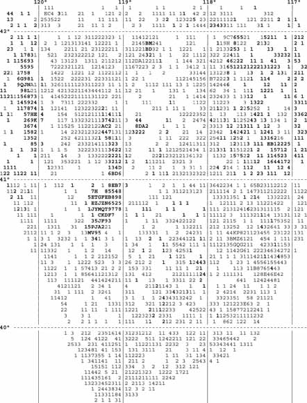
Index map showing distribution of gravity data in study area. Numbers and letters indicate number of data points in 2.5-minute cells that include their south and east edges. Blank spaces indicate no data. For example, A indicates 10 data points, I and O are skipped, Y indicates 31 data points, and Z indicates 32 or more data points. Bold print indicates location that includes data points without map verification. North-south distances are exaggerated about 1.3 times east-west distances (from figure 7).
Locations of gravity data points have been expressed by the USGS in geographic coordinates since the early 1960's. The geographic frame of reference is the basis for data base formats, digitization, display of data, data reduction processes, and modeling.
Computer programs were written in the Fortran language to process and display gravity data with locations expressed in geographic coordinates. The programs and associated processes have been tested for gravity data collected in an area of about 125,000 square kilometers in northwest Nevada, southeast Oregon, and northeast California. This report discusses geographic aspects of data processing. Utilization of the programs begins with application of a template (printed in PostScript format) to transfer locations obtained with Global Positioning Systems to and from field maps and includes a 5-digit geographic-base map naming convention for field maps. Computer programs are used to display data values (printed in PostScript format) and data coverage, insert data into files, extract data from files, shift locations, test for redundancy, and organize data by map quadrangles. It is suggested that 30-meter Digital Elevation Models should be accessed by using the geographic-based USGS 7.5-minute map name as a file name rather than a local map name or other arbitray designation. For example, file "40117_B8.DEM" has a southeast corner at 40 degrees-7 minutes-30 seconds north latitude and 117 degrees-52 minutes-30 seconds west longitude.
Download this report as a 45-page PDF file (of98-233_text.pdf; 1.1 MB).
Although the computer programs have been developed, tested, and used by the U.S. Government, no warranty (expressed or implied) is made by the author or the U.S. Government as to the accuracy and functioning of the computer programs or constituent program parts. No representation is made that program usage would not infringe privately owned rights.
Download all of the software at once as a compressed file containing 25 items (of98-233_software.zip; 48 kB compressed and 392 kB expanded).
Go to the software folder that contains the 25 items (of98-233_software; 48 392 kB).
For questions about the content of this report, contact Don Plouff
Donald Plouff's Home Page
Donald Plouff, emeritus, Geophysical Unit of Menlo Park, U.S. Geological Survey
MS 989, 345 Middlefield Rd., Menlo Park, CA 94025
Plouff, Donald, 1998, Computer programs to display and modify data in geographic coordinates and methods to transfer positions to and from maps, with applications to gravity data processing, global positioning systems, and 30-meter digital elevation models: U.S. Geological Survey Open-File Report 98-233, 45 p. [https://pubs.usgs.gov/of/1998/of98-233/].
Download a copy of the latest version of Adobe Reader for free.
|
Help |
PDF help |
Publications main page |
| Western Open-File Reports for 1998 |
| Geologic Division |
Geophysical Unit of Menlo Park, Calif. (GUMP)
|
This report is also available in print from:
USGS Information Services, Box 25286,
Federal Center, Denver, CO 80225
telephone: 888 ASK-USGS; e-mail: infoservices@usgs.gov

![]() U.S. Department of the Interior | U.S. Geological Survey
U.S. Department of the Interior | U.S. Geological Survey
URL: https://pubs.usgs.gov/of/1998/of98-233/
Page Contact Information: Michael Diggles
Page Last Modified: July 13, 2007