| Setting -
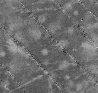
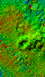
The maps presented here depict the northernmost part of Stellwagen Basin and the northwest
edge of Stellwagen Bank. The area mapped measures 3.7 x 3.8 nm (14 nm2)
and includes former and present disposal sites. This part of the Gulf of Maine was
occupied by glaciers that scoured and shaped the sea bed and deposited both fine and
coarse sediment. In this region, Stellwagen Basin is a relatively smooth surface that
varies from 80 to 90 m in depth. It is floored by a soft watery mud represented by low
backscatter (low reflectivity) values on the map. The smooth basin floor is interrupted by
elongate knolls which extend to heights of 15 m above the sea bed. The knolls are elongate
in a NW-SE direction, and their shape reflects the direction of movement of glacial ice.
The knolls are in various stages of burial by mud, but their surfaces are moderately
reflective to sound, suggesting that they are composed of glacial sand and gravel partly
covered by a thin veneer of mud. During post-glacial time, Stellwagen Basin has been
filling up slowly with mud that is derived from erosion of the land and of the sea bed in
coastal regions and shallow offshore banks. The mud is transported by tidal and storm
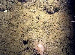
currents to the basin where it settles to the bottom and is habitat for groundfish,
shrimp, and many organisms that live in burrows in the sea bed. Stellwagen Basin extends
eastward to a slope approximately 25 m high that forms the edge of Stellwagen Bank. The
top of the bank here lies at a water depth of approximately 50 m and is composed of hard
gravelly sand with scattered cobbles and boulders that are highly reflective to sound
waves. The bank is relatively uniform in depth, and the surface displays shallow
depressions and low gravel ridges that exhibit several meters of relief and are
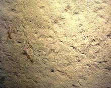
interpreted to be of glacial origin. The gravelly sand supports a variety of
burrowing anemones, sponges, and other organisms that attach to the hard bottom and form
part of the habitat utilized by groundfish.
|
||
|
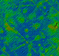
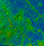
Dredged materials - Deposits of soft materials (such as sediment dredged from harbors) are common features in the backscatter images of the basin. These deposits are subcircular or linear in shape and are considerably more reflective than the basin mud. Subcircular (or point) deposits range in diameter from 10 to over 100 m and do not make a detectable mound on the sea bed. Linear deposits of this dredged material range up to 4 km in length. Linear deposits, as well as aligned sets of point deposits, are the result of dumping from moving barges. The cumulative effect is a collection of lines and dots that reveals transport patterns to and from the disposal sites. The alignment of the deposits suggests that many of the barges were headed for the present disposal point that has been active for 11 years since 1985. | |
|
Disposal mounds - Two mounds of disposed material in the basin are visible in the topographic image. The first is a large low mound (42� 25.7N, 70� 35.0'W) located where the "A" buoy marked a disposal point from 1975 to 1985 in the IWS and later in the iMBDS. This mound extends a few meters above the surrounding sea bed and is situated on the north side of a seafloor depression outlined by the 90-meter isobath. Its longest dimension is approximately 1000 m in a NE-SW direction. The second mound (42� 25.1'N, 70� 34.5'W) is younger, smaller, and steeper and is located 0.6 nm to the SE, at the active disposal point in the MBDS. This mound has been growing for 11 years since 1985 and is much better defined than the older mound to the north. It extends 6 to 7 m above the sea bed, and its longest dimension is approximately 800 m in an E-W direction. It also is more highly reflective than the northern mound which suggests that the surface of the northern mound has been altered during the past 11 years by natural fine-grained sedimentation, by burrowing organisms, and possibly by trawling. A disposal mound is not evident at the disposal point (42o 26.8'N, 70o 35.0'W) that was active from 1963 to 1975. | |
|
|
Anchor scars - The topographic image reveals features on the present disposal mound that are interpreted to represent disturbance of the bottom by the anchoring apparatus of a series of taut-wire buoys that have marked the MBDS disposal point since 1985. The features are not visible in the backscatter images. The anchor scars are doughnut-shaped and probably were formed by a heavy weight that is attached to the lower end of the anchor wire. The weight, and the chain that separates it from the anchor, apparently plow the mud into a circular ridge around the anchor as tidal and storm currents move the surface buoy and weight around the anchor point. Anchor scars are most visible on the periphery of the mound. The buoy is not set in precisely the same location each time it is replaced (some anchor scars are up to 600 m apart), a practice that encourages lateral growth of the disposal mound. |
Rock piles on the bank |
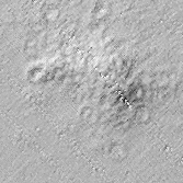
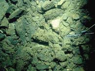
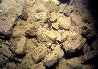
Rock debris
- Fresh blasted rock debris that was excavated from beneath Boston Harbor during
construction of the Ted Williams Tunnel (formerly known as the Third Harbor Tunnel) was
disposed in the iMBDS during a 17-month period from June 1992 to October 1993 (U.S. Army
Corps of Engineers, Rock Disposal Summary, T.J. Fredette, personal communication, 1995). A
special unbuoyed disposal point (42o 26.5'N, 70o
34.0'W) was designated for the location of this rock material. The point is located on the
edge of Stellwagen Bank (50 m water depth) where the sea bed is gravelly sand. A large
quantity of the rock debris lies within a 200-m radius of the disposal point, but other
deposits of rocks are scattered throughout the disposal region where they lie on gravelly
sand on the bank and on mud in the basin. The rock debris is relatively easy to identify.
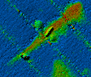
In the topographic image, it appears as large rough-surfaced mounds and low linear
deposits on the hard gravelly sand in shallow water (50 m) of the bank. In the backscatter
image, the highly reflective rock debris is characterized by higher backscatter values
than the gravelly sand; backscatter patterns depict mounds, low linear deposits, and areas
where rock material was widely scattered as it was dumped from moving barges. By contrast,
the rock debris that lies in the basin shows little or no topographic relief because,
apparently, the rock piles settled into the mud. The rock deposits are much more
reflective than the mud or the soft disposed material in the basin and often display a
distinctive shape in the backscatter images. A central elongate area (the main pile) is
highly reflective and is bounded on each side by semicircular features of lower
reflectivity that may represent scattered rocks on the fringe of the main pile or mud
disturbed by impact during dumping. Rock deposits that are situated on the slope between
the basin and the bank are highly reflective, but they have no topographic expression. In
addition, the lateral, semicircular features associated with rock debris on mud are not
visible. A possible explanation is that the rock deposits are thin and/or their relief is
somehow obscured by the slope of the bank edge; and lateral features are not present
because the bank edge is not soft mud but a relatively thin layer of mud overlying hard
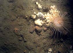
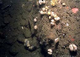
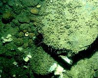
gravelly sand. Observations made in 1995 and 1996 with video and still cameras show that
rock debris on the bank (in place a maximum of 3 years) is only sparsely colonized by
attached organisms such as sponges, bryozoa, and hydrozoa. By contrast, these same
organisms are commonly attached to the pebbles, cobbles, and boulders found on the natural
gravelly sand adjacent to the rock debris. In the basin, rock debris is lightly veneered
with mud. Rock piles both on the bank and in the basin provide habitat for lobsters and
redfish. The locations of the new rocky habitat can be determined to a great extent by the
presence of buoys marking positions of lobster fishing gear.
|
|
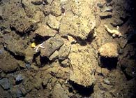
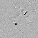
Sun-illuminated topographic images of sunken vessels and rock debris
|
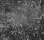
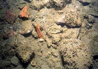
Sunken vessels and unidentified objects - A variety of unnatural features that appear to be man-made and that range from 10 to 70 m in length are present on the topographic and backscatter images. Sunken vessels are identified by their elongate shape and topographic expression. A total of 13 sunken vessels are shown here, but none of them have been visually observed or identified. The largest is approximately 70 m in length (42o 26.27'N, 70o 36.36'W). In addition to the vessels, 20 unidentified objects are mapped that do not have identifiable shapes but, in part, could be small vessels. In the backscatter images, a large circular object is present (42o 23.95'N, 70o 36.68'W) that has an inner "ring" approximately 70 m wide and an overall diameter of approximately 100 m but little topographic expression. It is unclear whether this large object is the remains of the drydock caisson noted near this location on NOS Chart 13267 (NOAA, 1994). | |
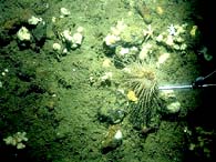
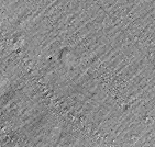
Sun-illuminated topographic image of depression with rim (only visible at this scale)
|
grayscale |
Depressions in the sea bed - Two kinds of depressions in the sea bed are recognized. Three shallow (0.5-1 m) subcircular depressions (50-100 m in diameter) with a raised rim are visible in both the topographic and the backscatter images. They resemble buoy anchor scars in some respects, and 2 of the 3 are located on the mound of disposed material that was deposited from 1975 to 1985. However, they differ from the anchor scars described previously by their large size and their reflectivity. A second kind of depression has a strong topographic expression, but it has no raised rim and is not visible in backscatter images. Fourteen shallow (1-2 m), irregularly-shaped depressions range from 20 to 70 m in their longest dimension. Eleven of the 14 depressions are clustered in an area of the basin where from 1963 to 1975 the U.S. Coast Guard maintained a buoy marking a disposal point (42o 26.8'N, 70o 35.0'W) for a variety of materials, apparently including munitions. These 11 depressions lie within 600 m of this disposal point, and it is conceivable they were formed by exploding munitions on the sea bed. This explanation is conjecture, but it might explain the presence of shallow, sharply defined depressions (in a uniformly smooth mud sea bed) whose formation is not related in an obvious way to disposal of other materials or to natural processes. |
|
||
|
||

.gif)