
By: M.G. Bonilla
1998
|
|
View the database explanation pamphlet as an unformatted, text-only file: sfs_db.txt (33 kB)
View the database explanation pamphlet as a formatted PDF file: sfs_db.pdf (56 kB)
Download the database explanation pamphlet as a formatted PostScript plot file: sfs_db.ps (554 kB)
View the geologic map sheet as a JPEG file (base-map partially removed): sfsmap.jpg (207 kB)
View the geologic map sheet as a PDF file: sfsouth.pdf (4 MB)
Download the database package in ARC/INFO 7.x uncompressed export format along with supporting materials in a compressed UNIX tar file (see the database explanation pamphlet for details): sfs_data.tar.gz (6.2 MB compressed download file, 19 MB when uncompressed)
Download one Postscript plottable file containing an image of the geologic map and base maps at a scale of 1:24,000, explanation sheet, and explanatory text in a compressed UNIX tar file (see the database explanation pamphlet for details): sfs_psmap.tar.gz (10.9 MB compressed download file, 18.5 MB when uncompressed)
Download one PDF file containing an image of the geologic map and base maps at a scale of 1:24,000, explanation sheet, and explanatory text in a compressed UNIX tar file (see the database explanation pamphlet for details): sfs_pdfmap.tar.gz (4.2 MB compressed download file, 4.2 MB when uncompressed)
|
|
For more information on the geology of the San Francisco Bay region: Visit the sfgeo website |
 Go to Western Region Geologic Information home page
The URL for this page is: https://pubs.usgs.gov/of/1998/of98-354/
Go to Western Region Geologic Information home page
The URL for this page is: https://pubs.usgs.gov/of/1998/of98-354/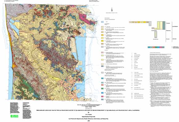
