
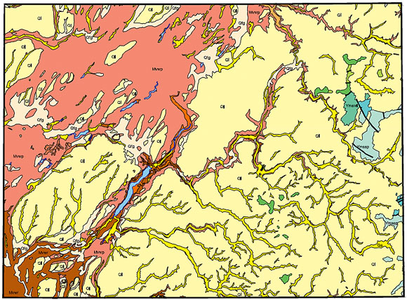
Most of the Rosalia 1:100,000 quadrangle, WA and ID, is covered with Quaternary deposits of alluvium, loess, and Outburst Flood sediments (shown in yellows and salmon colors), Mesozoic basalt (oranges and magenta colors) with smaller areas of Precambrian rocks (blue, green, purple, and gray colors).
The geologic map of the Rosalia 1:100,000-scale quadrangle was compiled in 1990 by S.Z. Waggoner of the Washington state Division of Geology and Earth Resources. This data was entered into a geographic information system (GIS) as part of a larger effort to create regional digital geology for the Pacific Northwest. The intent was to provide a digital geospatial database for a previously published black and white paper geologic map. This database can be queried in many ways to produce a variety of geologic maps. Digital base map data files are not included: they may be obtained from a variety of commercial and government sources. This database is not meant to be used or displayed at any scale larger than 1:100,000 (e.g., 1:62,500 or 1:24,000) as it has been somewhat generalized to fit the 1:100,000 scale map.
The map area is located in eastern Washington and extends across the state border into western Idaho. This open-file report describes the methods used to convert the geologic map data into a digital format, documents the file structures, and explains how to download the digital files from the U.S. Geological Survey public access World Wide Web site on the Internet.
We wish to thank J. Eric Schuster of the Washington Division of Geology and Earth Resources for providing the original stable-base mylar and the funding for it to be scanned. We also thank Dick Blank and Barry Moring of the U.S. Geological Survey for reviewing the manuscript and digital files, respectively.
Files available for downloading:
View ReadMe file (2.5 kb)
Download Open-File Report 98-357 as a PDF file (8 kb).
Download the Rosalia quadrangle datasets (including metadata) in compressed tar (covers.tar.Z) Arc/Info Export format: (455 kb download file, 1.8 MB uncompressed).
Download Text and AML files needed to re-create the paper maps in a GIS. This file is in UNIX compressed tar format (amls.tar.Z) and includes several ASCII files including Arc/Info plot AMLs, key files, and explanatory text. (95 kb,264 kb uncompressed.
Download additional Arc/Info Export-format files needed to re-create the paper maps in a GIS. This file is in UNIX compressed tar format (more.tar.Z) (120 kb download file, 1.2 MB uncompressed).
Download Maps prepared from the digital dataset, in UNIX compressed format (maps.tar.Z) for a variety of file formats including GRA, HPGL2, and PostScript (3.0 MB download file, 7.6 MB uncompressed HPGL2). The map scale is 1:100,000. Map sheet size is approximately 39 by 29 inches. The map is oriented with the long axis in the x-direction for plotting. The Arc/Info HPGL2-format map file (ros100k.hp) was designed to be plotted on a HP Inkjet Plotter (model 650-C), but can be plotted on any full-color (inkjet or electrostatic) plotter which will accept HPGL2 code.
For questions about the scientific content of this report, contact Pamela Derkey
Download a free copy of Adobe Reader
USGS Information Services
Box 25286 Federal Center
Denver, CO 80225
Telephone: 1-888-ASK-USGS
E-mail: infoservices@usgs.gov
| Help
| PDF help |
| Publications main page
| Western Open-File Reports for 1998 |
| Department of the Interior
| U.S. Geological Survey
| Geologic Division |
| Western Mineral Resources
| Western Region GIS Home Page |
| Privacy Statement
| Disclaimer
| Accessibility |
The URL for this page is:
https://pubs.usgs.gov/of/1998/of98-357/
Please send comments and suggestions, or report problems, to:
Michael Diggles
Updated:September 30, 1998 (pdd)
Updated: May 31, 2007 (bwr)
Updated: October 3, 2008 (mfd)