Kansas Geological Survey
1930 Constant Avenue
Campus West, University of Kansas
Lawrence, KS 66047
Telephone: (913) 864-3965
Fax: (913) 864-5317
e-mail: david@kgs.ukans.edu
Geologic mapping in three dimensions has become a practical reality for the individual scientist with the evolution of powerful, low cost, high-speed workstations. Vast quantities of subsurface data are stored in wireline logs obtained from wells drilled in the search for petroleum, water, geothermal, and other natural resources. Visualization techniques use the processing power of the computer to merge various transformations of these multi-dimensional data with the natural interpretive abilities of the human visual system. 'Intelligence amplification' (Schroeder and others, 1998) is clearly manifest as visualization techniques open a window to our view of the subsurface geologic data contained in wireline logs.
This paper will discuss visualization of subsurface geology as achieved by COLORLITH, a software system developed at the Kansas Geological Survey in an effort to provide low-cost, high- resolution, interpretation, and visualization of well log data from a single well or multiple wells. The COLORLITH system is designed for use in the convenient environment of individual workstation technology. As raw data is transformed and presented anew to the scientist, student or lay public, dramatic visual perception occurs of the previously unseen lithologic or petrophysical variations that exist within and between wells in the subsurface. This visualization of well log data, combined with both vertical and horizontal scaling capabilities, facilitates the understanding of geologic problems at scales ranging from facies changes within the producing zones of an oil field to the broad structural framework of a region.
The COLORLITH concept and its initial versions were developed and published in the late 1980's (Collins and Doveton, 1986, 1989). When dealing with data from a single type of log (e.g., gamma ray), the full range of possible readings or measurements from the log is divided into intervals. Each interval is then associated with a specific hue in a color spectrum, or a specific intensity of a single hue (including shades of gray). An image of the data recorded in a well is then generated by a vertical succession of colors or hues corresponding to the succession of log readings with depth in the well. When multiple logs are available from a single well, visualization can take advantage of orthogonal color schemes (RGB, CMY, or HLS). An individual log, or a parameter derived from analysis of multiple logs, is assigned to each of the three colors in the selected scheme. Value intervals from each log or parameter are then linked to intensities of the assigned color, as in the case of a single log. At each recorded log depth, the resulting log image displays a hue derived by mixing the intensities calculated at that depth for the three orthogonal colors. Through careful selection of logs or parameters associated with the three color axes, a direct interpretation of lithology based on displayed colors is possible. The potentials for application of this type of data visualization have been discussed extensively (Collins and Doveton, 1988; Collins, Ross, and Brownrigg, 1995; Doveton, 1994).
Color imaging technology available at the time of its initial development limited the use of COLORLITH to presentation of individual well images at a computer terminal or required the use of very expensive electrostatic plotters for color presentation of regional cross sections. The software was also very computer system specific, running on a large minicomputer. Early versions of COLORLITH were tailored to nonstandard log data formats associated with digital log data available in Kansas at the time. Each of these factors limited general application of the system.
In its current version (Collins, 1997a, 1997b), the COLORLITH system is designed to run in UNIX workstation environments. Source code is written in FORTRAN77 and is suitable for compiling and execution on Windows 95 or Windows NT desktop systems. Input log data is expected in the Canadian Log ASCII Standard (LAS) format (Canadian Well Logging Society, 1991). Output from COLORLITH is written as a PostScript file that can be imported to a variety of graphics editors or converted to plot file formats for low-cost, high-resolution, color ink-jet plotters. COLORLITH is specifically designed to analyze and display gamma ray and lithodensity logs. Other logs are handled in a more generalized manner.
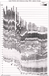
Gamma ray logs, treated independently of other log types, can be presented as well images using gray levels or a color spectrum to reflect gamma ray intensity. Figure 1 presents a regional cross section of Permian and Cretaceous formations spanning a geographic distance of 96 miles along Township 16S, from Range 43W in northwest Greeley County to Range 26W in northern Ness County, Kansas. Images for each of the 39 wells are derived from gamma ray logs. The narrow (10-20 ft) light band that begins at an elevation of 1200 feet above sea level in the west (left side of the cross section) and ends at an elevation of about 590 feet in the east corresponds to the Stone Corral Formation at the base of the Nippewalla Group in the Lower Permian. The broader (50-80 ft) light band that begins at an elevation of 3000 feet above sea level in the west and ends at about 2350 feet above sea level in the east corresponds to the Fort Hays Limestone Member of the Niobrara Chalk in the Upper Cretaceous. In this figure, the individual well images have been evenly spaced to emphasize vertical variations in lithology (and provide compact presentation). Alternative spacing options related to distance between wells are available.
|
Figure 1. Gray scale images of gamma ray logs from 45 wells for visualization of regional subsurface geology. |
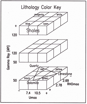
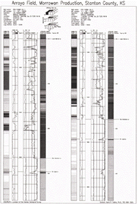
Readings taken at each depth on the lithodensity logs are used to derive parameter values for apparent density (RHOmaa) and photoelectric absorption (Umaa). RHOmaa and Umaa parameters are respectively assigned to the red and green axes. Adding readings from the gamma ray log, assigned to the blue axis, creates an enhanced lithology color crossplot (Figure 2). COLORLITH uses the mix of primary color intensities associated with parameters in this orthogonal scheme to generate a color log image reflecting changes in lithology with depth. Figure 3 presents a comparison of two wells for which gray scale gamma ray and color lithology logs have been generated. The gamma ray and lithodensity log data is also displayed in the more conventional graph format. In Figure 3 the relative vertical positions of the two wells have been shifted from a sea level datum to a new datum at the top of the Lower Morrow Limestone. In the same manner, the structural cross-section of Figure 1 could be converted to a stratigraphic cross section.
|
Click on thumbnail for full-scale image [278K] |
| Figure 2. Color cube crossplot of lithology based on parameters derived from lithodensity log data. | Figure 3. Visualization of subsurface variations in lithology through imaging of gamma ray and lithodensity logs (shown in gray scale for publication) from two wells in the Arroyo Field (Morrowan production, Stanton County, KS). Depths are in feet. |
Quality of regional cross section images derived from well log data can be improved (for purposes of stratigraphic evaluation) if the readings from individual logs are normalized in some manner. Occasionally readings for a log will have compressed or expanded ranges due to circumstances at the time of logging (possibly due to miscalibration). Using typical raw data, images for individual wells frequently appear to have a color shift relative to the images of surrounding wells. Even between separate logging runs on the same well, gamma ray readings may differ by more than 10%. Requirements for determining the precision of wireline logs are rarely included in logging contracts (Griffiths and Bakke, 1990).
In earlier versions of COLORLITH, normalization was based on prior calculations of regional trends in gamma ray intensity along selected geologic formations that persist across the section. This technique required picking the depth interval within each well (subscript j) for a formation with typically high readings (e.g. a dark shale) and a formation with typically low readings (a clean limestone). Average gamma ray readings were calculated for each interval (avgrlj and avgrhj). Regional trends in average gamma ray readings as a function of location (tgrlj and tgrhj) were calculated for the two formations. The difference between the low and high average readings and the corresponding trend values (dgrlj = tgrlj - avgrlj; dgrhj = tgrhj - avgrhj) were calculated. These were the basis for linear scaling, at each depth (subscript i) on the well log, of changes (dgrij) from the original gamma ray reading (grij) using the relationship: (dgrij - dgrhj) / (dgrlj - dgrhj) = (grij - avgrhj) / (avgrlj - avgrhj). The resulting normalized gamma ray reading (ngrij) is then: ngrij = grij + dgrij. The procedure was designed to eliminate locally anomalous logging results while accepting regional variation. Unfortunately, for large numbers of wells this can be a very time consuming and labor intensive process.
COLORLITH now incorporates a simpler process for normalization. In Figure 1, the gamma ray readings from all the wells are normalized in a fully automated procedure before calculating the shade of gray for each depth. The gamma ray log of a selected well (subscript ty) is used as a type log for the cross section. The mean (mty) and standard deviation (sdty) of gamma ray readings are calculated over the displayed interval of the type log. Then, for each well (subscript j) in the cross section, the mean (mj) and standard deviation (sdj) of the raw gamma readings are calculated over the displayed interval of well j. At each depth interval (subscript i) in well j, the normalized gamma ray reading (ngrij) is then calculated from the original gamma ray reading (grij) by translating the mean to zero (subtracting mj), scaling from the original standard deviation to the type standard deviation, and translating the mean to the type log mean (adding mty). The normalization function is expressed as follows: ngrij = (grij - mj) X (sdty/sdj) + mty.
The interpretive power of visualization achieved by COLORLITH encouraged a related effort at the Kansas Geological Survey. Well log data from a regional sequence of wells have been converted to the format of seismic trace data (Carr and others, 1995). This permits display and analysis of the data on high-speed workstations using software and hardware designed for optimal handling of the extremely large data volumes associated with seismic exploration. Seismic processing systems are specifically designed to analyze data with high horizontal density but low vertical resolution. Well log data, in contrast, is characterized by very high vertical resolution but low vertical density. Caution is therefore advised when applying various data analysis and transformation capabilities of seismic processing systems to well log data.
Another promising, but untried, technique would utilize 3-D visualization capabilities of computer aided drafting (CAD) systems. Like the previous technique, CAD systems were not originally designed for interpretation of well log data. With CAD systems, well log data would be viewed as vertical columns in 3-D space. Conceptually, there would be no difference between a well drilled in the ground or a support column within a major convention center. The only major obstacle to this application may be limits to the ability of specific CAD systems to handle visualization of columns with patterns of bands on individual columns involving rapidly changing color and band widths. Such systems may view data from a single well as a stack of many cylindrical disks with changing colors and thickness. Once implemented, the geologist could walk through the subsurface just as an architect would walk a client through the virtual reality of a proposed building.
Wireline data from well logs adds one or more dimensions of measured physical parameters to the three dimensional measurements of position in space (more specifically, the subsurface). Visualization techniques are well suited to interpretation of data having many dimensions. These techniques involve data transformations and presentations in which new information is repeatedly created and modified to enhance the meaning of the original data. Visualization is an interactive process, that directly engages the scientist and the natural abilities of the human visual system to interpret spatial relationships (Schroeder and others, 1998).
This paper has described COLORLITH; a relatively simple system providing the individual scientist with a variety of options for visualization of well log data. The techniques are very general, based on widely used input data formats, and are easily adapted to other uses. Important objectives in the development of COLORLITH have been the focus on effective visualization techniques for the individual workstation while avoiding requirements for high end processing or reproduction technologies. There is significant potential for application of this system in both research and teaching.
Canadian Well Logging Society Floppy Disk Committee, 1991, LAS‹A floppy disk standard for log data: Geobyte, v. 6, no. 6, p. 56-61.
Carr, T., Hopkins, J., Feldman, H., Feltz, A., Doveton, J., and Collins, D., 1995, Transforms of wireline logs as pseudo-seismic traces: Technical Newsletter for Landmark Users, Landmark Corporation, January-February, p. 16-21.
Collins, D.R., 1997a, Source code for the COLORLITH program for visualization of well log data from multiple logs and multiple wells: Kansas Geological Survey Open-File Report 97-89.
Collins, D.R., 1997b, Programs for analysis and visualization of lithodensity logs to enhance petroleum exploration efficiency, in Pawlowsky-Glahn, V., ed., Proceedings of IAMG'97; the third annual conference of the International Association for Mathematical Geology, International Center for Numerical Methods in Engineering (CIMNE), Barcelona, Spain, v. 1, p. 218-220.
Collins, D.R., and Doveton, J.H., 1986, Color images of Kansas subsurface geology from well logs: Computers and Geosciences, v. 12, no. 4B, p. 519-526.
Collins, D.R., and Doveton, J.H., 1988, Colour image transformations of wireline logs as a medium for sedimentary profile analysis: Bulletin of Canadian Petroleum Geology, v. 36, no. 2 (June 1988), p. 186-190.
Collins, D.R., and Doveton, J.H., 1989, Applying color information theory to the display of lithologic images from wireline logs: Geobyte, February, p. 16-24.
Collins, D.R., Ross, J.A., and Brownrigg, R., 1995, Management, analysis and display of digital well-log data for presentation of geologic information in the third dimension, Symposium Proceedings, Volume One, Ninth Annual Symposium on Geographic Information Systems, GIS World, p. 266-268.
Doveton, J. H., 1994, Geologic log analysis using computer methods, AAPG computer applications in geology, No. 2: Tulsa, OK, American Association of Petroleum Geologists, 169 p.
Griffiths, C.M., and Bakke, S., 1990, Interwell matching using a combination of petrophysically derived numerical lithologies and gene-typing techniques, in Hurst, A., Lovell, M.A., and Morton, A.C., eds., 1990, Geological Applications of Wireline Logs: Geological Society Special Publication No. 48, p. 133-151.
Schroeder, W., Martin, K., and Lorensen, B., 1998, The visualization toolkit, 2nd edition: Upper Saddle River, NJ, Prentice Hall, Inc., 645 p.
U.S.Department of the Interior, U.S. Geological Survey
<https://pubs.usgs.gov/openfile/of98-487/collins.html>
Maintained by Dave Soller
Last updated 10.06.98