CHAPTER 1. MAPS AND ILLUSTRATIONS SHOWING THE ACOUSTIC AND TEXTURAL CHARACTERISTICS AND THE DISTRIBUTION OF BOTTOM SEDIMENTARY ENVIRONMENTS, LONG ISLAND SOUND, CONNECTICUT-NEW YORK
Harley J. Knebel, Richard P. Signell, Richard R. Rendigs, Lawrence J. Poppe, and Jeffery H. List
US Geological Survey, Woods Hole, MA 02543
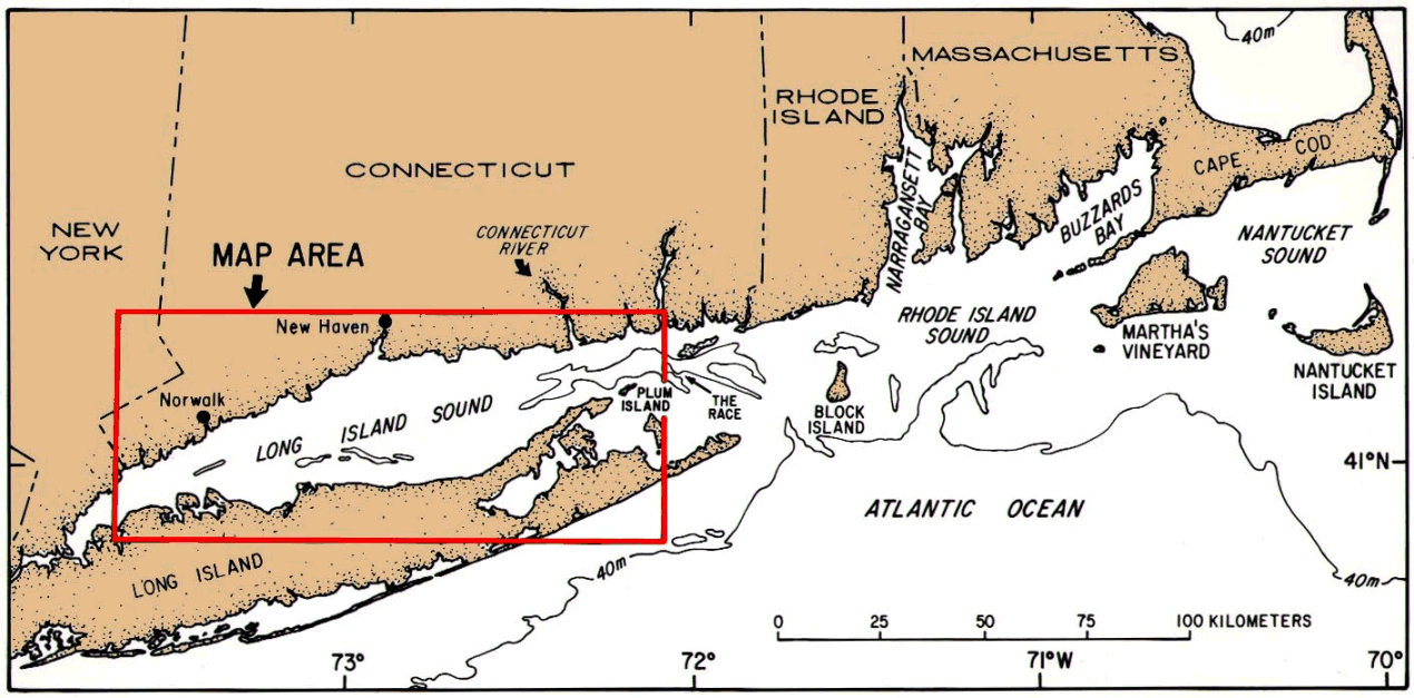
Long Island Sound is one of the largest estuaries along the Atlantic coast of the United States. It is a semi-enclosed, NE-SW trending basin which is 150 km long and 30 km across at its widest point (fig. 1). Its mean water depth is about 24 m. The eastern end of the sound opens to the Atlantic Ocean through several large passages between islands, whereas the western end is connected to New York Harbor through a narrow tidal strait. Fluvial input into the sound is dominated by the Connecticut River.
This study describes, illustrates, and briefly discusses the acoustic and textural characteristics and the distribution of bottom sedimentary environments in Long Island Sound. The study was undertaken as part of a larger research program designed to understand the regional processes that distribute sediments and the contaminants associated with them. The sound has received anthropogenic wastes and contaminants from numerous sources including wastewater treatment plants, industrial facilities, riverine input, urban runoff, and airborne transport (Wolfe and others, 1991). Knowledge of the bottom sedimentary environments is essential in understanding the long-term fate of wastes and contaminants that have been or will be introduced into the area. This report highlights the major findings presented in a recent paper by Knebel and others (1999) and includes additional maps not included therein. The reader is urged to consult the full text of the earlier paper for a more definitive treatment of the data and for appropriate supporting references.
The study area encompasses approximately 2,200 km2 of the basin floor having water depths greater than 10 m. It is bordered by the Connecticut and Long Island nearshore areas on the north and south (fig. 1).
Geologic History and Sedimentary Framework
Glaciation, ice retreat, and marine submergence characterize the late Quaternary geologic history of Long Island Sound (Bloom and Stuiver, 1963; Lewis and Needell, 1987; Needell and others, 1987; Lewis, 1989; Gayes and Bokuniewicz, 1991; Lewis and Stone, 1991; Stone and Lewis, 1991). During Pleistocene time, glaciers advanced southward across the sound and deposited drift over the irregular, scoured surface. The Laurentide (last) ice sheet reached southern Long Island where its position is marked by a series of end and recessional moraines. During the northward retreat of this ice sheet, meltwater was impounded between the ice front and the northern coast of Long Island, creating glacial Lake Connecticut which encompassed most of the present sound area. The retreating ice also deposited coarse-grained, topographically irregular, drift (including lacustrine-fan, morainal, and glacio-deltaic deposits) along the Connecticut coast and nearshore area. As its spillway (located at The Race; fig. 1) was eroded, glacial Lake Connecticut drained, and the lake bed eventually was subaerially exposed. Long Island Sound was created when the basin was resubmerged by the postglacial eustatic rise of sea level. During the transgression, an extensive marine delta was deposited in the eastern part of the sound when sea level was at -40 m; this was caused by the rapid erosion of the lake bed of glacial Lake Hitchcock located within the Connecticut River valley. As marine submergence continued, tidal currents extended their reach throughout the basin and, eventually, controlled the distribution of sea-floor environments.
Bottom Topography
The sea floor is generally irregular in the funnel-shaped eastern part of the sound (fig. 2). It is especially rugged across the eastern entrance to the sound where scour depressions are associated with the narrow passages between islands. Water depths within these depressions typically reach 40 to 50 m and, in places, exceed 100 m. West of the mouth of the Connecticut River (for a distance of 20-25 km), the bottom is characterized by a series of hummocky, ENE-WSW trending, tidal ridges and channels (Fenster and others, 1990; Fenster, 1995). Water depths in this area are generally less than 50 m, and relief of 20 to 30 m is common.
The topography in the central and western parts of the sound consists of broad areas of smooth sea floor separated by the Stratford and Norwalk Shoal complexes (fig. 2). In areas of smooth sea floor, the bottom slopes toward an E-W axial depression which has thalweg depths of 30 to 60 m and is about 77 km long. The axial depression is narrowest and deepest where it cuts across the shoal complexes. Small knolls and low ridges locally protrude above the smooth sea floor, especially along the nearshore margins. The Stratford and Norwalk Shoal complexes comprise irregular assemblages of topographic highs and lows that are oriented N-S across the sound and that have maximum relief of about 40 m.
Hydrodynamic Setting
The bottom circulation in Long Island Sound is dominated by the lunar semi-diurnal tide (Riley, 1956; Gordon and Pilbeam, 1975; Bokuniewicz and Gordon, 1980b; Ianniello, 1981; Kenefick, 1985; Signell and others, 1998). Maximum near-bottom tidal-current speeds (during a tidal cycle) generally decrease from more than 80 cm/s at the eastern entrance to the sound to less than 20 cm/s near the western end. However, they are locally variable due to the irregular basin topography. The set of the tide is mainly along the NE-SW axis of the sound.
Nontidal estuarine circulation exists within the sound throughout the year (Riley, 1956; Gross and Bumpus, 1972; Hollman and Sandberg, 1972; Gordon and Pilbeam, 1975; Paskausky and Murphy, 1976; Wilson, 1976; Bokuniewicz and Gordon, 1980a; Kim and Bokuniewicz, 1991). Residual bottom currents due to estuarine circulation flow W and SW into the sound and reach speeds of about 5 to 10 cm/s in the eastern part and 5 cm/s in the western part.
Wind- and wave-driven bottom currents in the sound are quite variable, depending on wind speed, direction, duration, and fetch (Bohlen, 1975; Bokuniewicz, 1980; Bokuniewicz and Gordon, 1980a; Fredette and others, 1988; Signell and others, 1998). Wind-driven bottom currents are the greatest when strong winds blow along the length of the sound during storms. At these times, the bottom flow is generally downwind along the shallow margins and against the wind within the axial depression in the central and western sound. Wave-produced currents primarily affect the bottom flow in water depths of 20 m or less.
The acoustic characteristics and the distribution of bottom sedimentary environments in the study area were interpreted primarily from a regional set of sidescan sonographs (fig. 3). This set of sonographs was obtained along 1,120 km of tracklines using a sidescan-sonar system that operated at a frequency of 100 kHz and scanned 187 m to each side of the ship=s track. Ancillary sonographs were obtained: (1) along four NE-SW transverse lines located about 20 km SW of the Connecticut River; (2) along two short longitudinal lines located just north of Long Sand Shoal; and (3) within five local survey areas (having nearly complete sea-floor coverage) located throughout the basin (Poppe and others, 1997, 1998, 1999; Twichell and others, 1997, 1998) (fig. 3). Navigational control for all tracklines was provided by differential GPS.
The textural characteristics of the sea-floor environments were based on grab samples and video-camera observations obtained at 146 strategic locations along or near the regional survey lines (fig. 3). Subsamples were taken from the upper 2 cm of the sediments in the grabs, and these were subjected to complete grain-size analyses. Shell fragments greater than 1 mm were removed from the subsamples before analysis.
In addition to the sonographs and the textural observations, this study made use of a large amount of supplemental marine geologic data. These data included: (1) high-resolution, seismic-reflection profiles (2-7 kHz or 3.5 kHz) collected concurrently with all sonographs; (2) previous geologic maps based on a regional set of subbottom (boomer) profiles (Lewis and Needell, 1987; Needell and others, 1987; Lewis and Stone, 1991); (3) prior regional maps of bottom-sediment types (Feldhausen and Ali, 1976; Reid and others, 1979; Williams, 1981; National Ocean Service, 1989a, b); (4) a regional suite of vibracore samples (Donohue and Tucker, 1970; Williams, 1981; Lewis and Needell, 1987; Needell and others, 1987; Szak, 1987); (5) the detailed bathymetry (contour interval = 1-2 m) of the basin floor (U.S. Geological Survey, 1984, 1986; National Ocean Service, 1989a,b); and (6) modeled tidal-, wind-, and wave-produced bottom currents (Knebel and others, 1999; Signell and others, 1998).
ACOUSTIC AND TEXTURAL CHARACTERISTICS OF ENVIRONMENTS
Four categories of bottom sedimentary environments were identified in the study area from the textural observations (fig. 4), seven characteristic sonograph patterns (fig. 5), and the supplemental marine geologic data (Knebel and others, 1999). These environments reflect the dominant long-term processes of: (1) erosion or nondeposition; (2) coarse-grained bedload transport; (3) sediment sorting and reworking; and (4) fine-grained deposition. It should be noted that atypical processes (such as storm erosion in fine-grained depositional areas) can sometimes affect the sea floor within each environment. Such atypical processes could not be recognized from the available data because they did not leave a permanent imprint on the bottom.
Environments of Erosion or Nondeposition
Environments of erosion or nondeposition appear on the sonographs either as patterns with isolated reflections (fig. 5A) or as patterns of strong backscatter (fig. 5B) (Knebel and others, 1999). Patterns with isolated reflections have a Aspeckled@ appearance produced by strong backscatter from numerous boulders or rock masses (3 m or less in diameter) on the sea floor. Gravel-size sediments are ubiquitous in these areas, and ripples (wave lengths = 10-20 cm) often are present in sediment patches among the boulders and rock masses. Where sediments could be recovered, they were primarily gravelly coarse sands (fig. 4). Patterns of strong backscatter, on the other hand, appear as nearly uniform dark sonographs. In places, these patterns exhibit small, low bedforms (wave lengths = 4-10 m; heights = less than 0.25 m) and scattered boulders. Sediments from these areas were mainly sandy gravels and gravelly coarse-to-medium sands (fig. 4).
Environments of Coarse-Grained Bedload Transport
Coarse-grained bottom-sediment transport is indicated by sonograph patterns of sand ribbons and sand waves (fig. 5C) (Knebel and others, 1999). Sand ribbons appear on the sonographs as elongate bands (typically 20-250 m wide) of alternate strong and moderate backscatter. They are oriented ENE-WSW parallel to the trend of the sound, have boundaries which vary from sharp to indistinct, and sometimes merge toward the WSW. Many sand ribbons have small bedforms (wave lengths = 5-10 m; heights = less than 0.25 m) on their surfaces, and some contain scattered boulders. Samples taken from sand-ribbon areas had textures which ranged from gravelly sands to relatively uniform medium-to-fine sands, although medium sand was a dominant or major component in all samples (fig. 4). The sand waves have spacings which range from 5 to 300 m and amplitudes which range from 0.25 m to more than 10 m. In the eastern sound, sand waves typically are oriented NNW-SSE, have steeper slip faces toward the WSW, and decrease in size and height from NE to SW. Locally, however, their orientations are variable on the upper flanks of larger tidal sand ridges. Ripples (wave lengths = 5-20 cm) are ubiquitous on their surfaces. Sediments from sand-wave areas were dominantly moderately-sorted, medium sands (fig. 4), although higher concentrations of coarse and fine sand were found at some sites. The sediments also included scattered gravel and shells that usually were concentrated in sand-wave troughs.
Environments of Sediment Sorting and Reworking
Environments of sediment sorting and reworking are characterized by sonograph patterns of moderate backscatter (fig. 5D) and by patterns with patches of moderate-to-weak backscatter (fig. 5E) (Knebel and others, 1999). Both patterns reflect a combination of erosion and deposition. Patterns of moderate backscatter depict areas of sediment sorting. Sediments in these areas are mostly fine-to-very fine sands (fig. 4), although they contain gradational admixtures of coarser and finer sediments near the boundaries with other environments. Scattered boulders and gravel were observed at some sites, especially along the nearshore margins. Patterns with patches of moderate-to-weak backscatter depict areas of sediment reworking. Patches within these patterns represent areas on the sea floor that range in size from a few meters to more than 200 m; some patterns had a mottled appearance. Video-camera observations show that the bottom sediments in these areas are heterogeneous, ranging from shelly sands with scattered gravel and degraded ripples to clean fine-grained sediments with faunal burrows; the transition from one sediment type to another can be abrupt. Sediments recovered in the grab samples typically contained a large proportion of silt-plus-clay, although the sediment types ranged from sands to sandy muds to muds.
Environments of Fine-Grained Deposition
Environments of deposition are depicted on the sonographs as patterns of weak backscatter (fig. 5F). These patterns generally are featureless except for broad gradational increases in acoustic return near areas with other environments. Such patterns are produced by relatively fine-grained bottom sediments which range from muddy very-fine sands to sandy muds to muds. As a group, these sediments had the finest grain sizes of the four sedimentary environments identified in the study area (fig. 4).
DISTRIBUTION OF SEDIMENTARY ENVIRONMENTS
Reconnaissance maps which show the locations of bottom sedimentary environments were constructed from the distribution of the characteristic sonograph patterns (figs. 6,7,8,9,10, and 11). The sonograph patterns were strongly correlated with topographic changes, sea-floor morphology, bottom-sediment types, and water depth. These correlations allowed us to infer the distribution of environments between cruise tracks and across similar bottom features.
Environments of erosion or nondeposition cover 10 percent of the study area (figs. 7, 8). In the eastern part of the area, they were found primarily across the rugged basin floor at the entrance to the sound and within an irregular nearshore depression landward of Long Sand Shoal. In the central and western sound, they were found atop the Stratford and Norwalk Shoal complexes, over small knolls and ridges (especially along the nearshore margins), and within the constricted axial depression where it cuts across the two shoal complexes.
Environments of coarse-grained bedload transport cover 16 percent of the study area (figs. 7, 9). These environments are restricted mainly to the east-central part of the sound. Here, sand ribbons were present within the large ENE-WSW oriented tidal channels, whereas sand waves were present on the tops and flanks of intervening tidal sand ridges (figs. 5C, 6). Sand waves also were found on the crests of a few small knolls in the western part of the study area.
Environments of sediment sorting and reworking cover 24 percent of the study area (figs. 7, 10). In the eastern sound, sediment sorting occurs within a wide curvilinear band that fringes the western limit of the zone of sand ribbons and sand waves. In the western sound, environments of sediment sorting occur: (1) over low knolls and ridges; (2) on the flanks of the shoal complexes; (3) within short sections of the axial depression near the Stratford Shoal complex; and (4) along a narrow strip which borders most of the southern nearshore margin. Environments of sediment reworking, on the other hand, cover only about 2 percent of the study area and are restricted to small isolated areas mainly in the western sound. Here, they were found on the crests and flanks of low knolls and along the axial depression.
Environments of fine-grained deposition cover 50 percent of the study area (figs. 7, 11). These environments occupy large areas of the central and western sound that have low sea-floor gradients. Across the widest part of the basin, they are present in a zone which is more than 30 km long. They also occupy most of the area between the two shoals complexes and were present within sizable areas west of the Norwalk Shoal complex.
The distributions of sonograph patterns and bottom sedimentary environments across the Long Island Sound basin are extremely patchy (figs. 6, 7, 8, 9, 10, and 11). On the reconnaissance maps, the sizes of individual patches that represent single environments range from about 100 m to more than 30 km. In the following discussion, we outline the regional and local conditions which have controlled this patchiness.
Regional Conditions
Regional changes in geologic and oceanographic conditions have produced a general E-to-W succession of sedimentary environments in Long Island Sound. At the eastern entrance to the sound, a large area of erosion or nondeposition is present across the rugged basin floor (figs. 7, 8). This is the result of strong bottom tidal currents which typically reach speeds of 50 to 60 cm/s and, in places, exceed 60 cm/s (Knebel and others, 1999; Signell and others, 1998). These strong currents have produced a sea-floor lag deposit composed of sandy gravel and gravelly coarse sand that is nearly in equilibrium with the modern current regime (Bohlen, 1982; Fenster, 1995). The lag deposit has been derived from the erosion and winnowing of the eastern flank of the marine delta which was deposited in this part of the sound during the postglacial rise of sea level (Lewis and Stone, 1991; Fenster, 1995; Stone and Ashley, 1995).
To the west, a zone of coarse-grained bedload transport (figs. 7, 9), which is mantled by sand ribbons and sand waves, has developed on the surface of the Holocene marine delta. Since its formation, the delta not only has supplied a large amount of coarse-grained sediments for subsequent transport, but it has been continually sculptured by strong tidal currents and by the lateral shifting and westward extension of major tidal channels (Fenster, 1995). Maximum near-bottom tidal currents in this zone exhibit a lateral gradient of speeds ranging from more than 50 cm/s in the E to about 40 cm/s in the W (Knebel and others, 1999; Signell and others, 1998). These speeds generally exceed the threshold of sediment movement for medium sand, the dominant textural component of the sand ribbons and sand waves. The net long-term sediment-transport direction in this area is toward the WSW due to the superposition of the estuarine circulation on the gradient of bottom tidal-current speeds (Gordon and Pilbeam, 1975; Wilson, 1976; Bokuniewicz and others, 1977; Bokuniewicz, 1980; Bokuniewicz and Gordon, 1980a).
Farther west, a broad curvilinear band of sediment sorting fringes the zone of bedload transport (figs. 7, 10). Here, gradational sorting is evident from a progressive E-to-W decrease in grain size that is accompanied by a decrease in acoustic backscatter (Knebel and others, 1999). Maximum near-bottom tidal current speeds across the band range from 30 to 40 cm/s and decrease from E-to-W in response to the widening of the basin (Knebel and others, 1999; Signell and others, 1998). These current speeds generally exceed the threshold of sediment movement for fine and very-fine sands (Miller and others, 1977), the dominant size fractions within the band. Sandy sediments brought to this area by the net westward bottom transport are sorted according to gradients of current speed and transport frequency (Knebel and others, 1999). These sorted sediments have been extended westward into the sound where they have either covered over or been mixed with older deposits (Donohue and Tucker, 1970; Bokuniewicz, 1980; Gordon, 1980; Fenster, 1995).
The band of sorted sediments, in turn, gives way to environments of fine-grained deposition that cover most of the central and western parts of the sound (figs. 7, 11). Depositional environments are characterized by relatively weak, near-bottom tidal currents with speeds that range from 10 to 30 cm/s (Knebel and others, 1999; Signell and others, 1998). In addition to a weak tidal-current regime, the accumulation of muddy sediments in depositional areas occurs via particle aggregates which are produced by biologic and chemical means and have settling speeds greater than those of constituent grains (Kranck, 1973, 1975; Biggs, 1978; Rhoads and others, 1978; Yingst and Rhoads, 1978; Knebel and others, 1999). Estimated rates of modern fine-grained sediment accumulation vary from 0.03 to 0.09 cm/y (Benninger and others, 1979; Benoit and others, 1979; Bokuniewicz and Gordon, 1980a; Kim and Bokuniewicz, 1991; Rhoads, 1994).
Local Conditions
The patchiness of bottom sedimentary environments in Long Island Sound also reflects local changes in sea-floor conditions. Such changes are the result of modifications of bottom-current strength and related sediment transport caused by the sea-floor topography.
Topographic highs in the central and western parts of the sound cause local increases in bottom tidal-, wind-, and wave-produced currents that, in turn, produce areas of sediment erosion, sorting, and reworking (Knebel and others, 1999) (figs. 2, 7, 8, 10). Areas of erosion or nondeposition are present on the tops of the Stratford and Norwalk Shoal complexes and over prominent nearshore highs. At these locations, coarse glacial drift (and possibly bedrock at a few sites) crops out or forms subcrops at the sea floor. On the other hand, environments of sediment sorting and reworking are present on the lower flanks of the shoal complexes and over subtle bathymetric highs. At these locations, the degree of current enhancement is less than that for areas of erosion or nondeposition, and the sediments reflect either selective winnowing or variable bottom flow.
Topographic enhancement of the bottom currents also causes local areas of sediment erosion, sorting, and reworking along the axial depression of the sound (Knebel and others, 1999). Areas of erosion or nondeposition are present in the most constricted part of the depression (where it cuts across the shoal complexes), and areas of sediment sorting and reworking are present along short sections of the depression near the Stratford Shoal complex (figs. 2, 7, 8, 10). Model results indicate that scour and winnowing in these areas can occur during westerly storms, when the westward-directed bottom flow along the axial depression reinforces the ambient flood-tidal currents and the near-bottom estuarine flow (Signell and others, 1998).
Wave-produced bottom currents cause environments of sediment sorting within a narrow strip along the southern nearshore margin of the basin and within discontinuous patches along the northern margin west of the Housatonic River (Knebel and others, 1999; Signell and others, 1998) (figs. 2, 7, 10). These areas are limited to water depths of 20 m or less, the approximate depth range over which wave-orbital speeds are strong enough to resuspend and winnow away most silt- and clay-sized sediments. Areas of sediment sorting are absent along other parts of the north-central nearshore margin because here the supply of fine-grained sediments is sufficient to offset losses due to wave resuspension and removal (Knebel and others, 1999).
Analyses of a regional set of sidescan sonographs, bottom samples, and video-camera observations together with supplemental marine geologic data outline the acoustic and textural characteristics and the distribution of four categories of sea-floor sedimentary environments (erosion or nondeposition; coarse-grained bedload transport; sediment sorting and reworking; and fine-grained deposition) within the glaciated, topographically complex Long Island Sound basin.
(1) Environments of erosion or nondeposition are defined on the sonographs by patterns with isolated reflections or by patterns of strong backscatter. These environments comprise exposures of glacial drift, coarse lag deposits, and possibly bedrock. Sediments within these environments range from boulder fields to gravelly coarse-to-medium sands. Environments of erosion or nondeposition are present across the rugged sea floor at the eastern entrance to the sound as well as atop bathymetric highs and within constricted depressions in the central and western parts of the basin.
(2) Environments of coarse-grained bedload transport are depicted by sonographs having patterns of sand ribbons and sand waves. Sand ribbons comprise elongate bands of sediments (typically 20-250 m wide) with textures ranging from gravelly sands to relatively uniform medium-to-fine sands, whereas sand waves have diverse wave lengths (5-300 m) and heights (0.25 m to more than 10 m) and consist primarily of medium sands. Environments of coarse-grained bedload transport occupy an extensive area on the surface of a postglacial marine delta in the eastern sound.
(3) Environments of sediment sorting and reworking are indicated on the sonographs by patterns of moderate backscatter and by patterns with patches of moderate-to-weak backscatter. Environments of sediment sorting contain mostly fine-to-very fine sands, whereas environments of sediment reworking contain diverse textures ranging from gravelly sands to muds. Sorted sediments are present within a wide curvilinear band across the eastern sound and within a narrow fringe along the southern nearshore margin. Other areas of sorted and reworked sediments are present atop low knolls, on the flanks of the shoal complexes, and within short segments of the axial depression in the central and western sound.
(4) Environments of fine-grained deposition are characterized by sonographs having uniform patterns of weak backscatter. Bottom sediments in these environments are muddy very-fine sands and muds. Environments of deposition cover broad areas of the generally flat basin floor in the central and western parts of the sound.
(5) The extreme patchiness of bottom sedimentary environments within Long Island Sound reflects both regional and local causes. Regional changes in sedimentary environments are the result of a strong E-to-W, decreasing gradient in bottom tidal-current speeds coupled with a net nontidal (estuarine) bottom drift. These conditions have produced a westward progression of environments ranging from erosion or nondeposition at the narrow eastern entrance of the sound, to an extensive area of coarse-grained bedload transport, to a peripheral band of sediment sorting, to broad areas of fine-grained deposition on the flat basin floor. However, fine-grained deposits in the central and western parts of the sound are discontinuous in local areas where the bottom flow is enhanced by and interacts with the sea-floor topography. In these areas, increased sediment transport has produced a patchy complex of other environments.
We thank R.S. Lewis and P.C. Valentine for constructive reviews of the manuscript. Thanks are also extended to M.B. tenBrink for providing samples for textural analysis, V. Cross for help in collecting and analyzing the sonographs, M. DiGiacomo-Cohen for providing geologic maps and sedimentary framework data, B. Taylor for completing the grain-size analyses, K. Parolski for help in conducting the field work, and J. Zwinakis and D. Blackwood for drafting and photography of the figures.
Benninger, L.K., Aller, R.C., Cochran, J.K., and Turekian, K.K., 1979, Effects of biological sediment mixing on the 210Pb chronology and trace metal distribution in a Long Island Sound sediment core: Earth and Planetary Science Letters, v. 43, p. 241-259.
Benoit, G.J., Turekian, K.K., and Benninger, L.K., 1979, Radiocarbon dating of a core from Long Island Sound: Estuarine and Coastal Marine Science, v. 9, p. 171-180.
Biggs, R.B., 1978, Coastal bays, in Davis, R.A., Jr., ed., Coastal sedimentary environments: New York, Springer-Verlag, p. 69-99.
Bloom, A.L., and Stuiver, M., 1963, Submergence of the Connecticut coast: Science, v. 139, p. 332-334.
Bohlen, W.F., 1975, An investigation of suspended material concentrations in eastern Long Island Sound: Journal of Geophysical Research, v. 80, p. 5089-5100.
Bohlen, W.F., 1982, In-situ monitoring and sediment resuspension in the vicinity of active dredge spoils disposal areas, in Proceedings, Oceans >82: Washington, D.C., Marine Technology Society, p. 1028-1033.
Bokuniewicz, H.J., 1980, Sand transport at the floor of Long Island Sound: Advances in Geophysics, v. 22, p. 107-128.
Bokuniewicz, H.J., and Gordon, R.B., 1980a, Sediment transport and deposition in Long Island Sound: Advances in Geophysics, v. 22, p. 69-106.
Bokuniewicz, H.J., and Gordon, R.B., 1980b, Storm and tidal energy in Long Island Sound: Advances in Geophysics, v. 22, p. 41-67.
Bokuniewicz, H.J., Gordon, R.B., and Kastens, K.A., 1977, Form and migration of sand waves in a large estuary, Long Island Sound: Marine Geology, v. 24, p. 185-199.
Donohue, J.J., and Tucker, F.B., 1970, Marine mineral identification survey of coastal Connecticut: East Hartford, Connecticut, Final Report to Connecticut Research Commission, J-970660-1, 385 p.
Feldhausen, P.H., and Ali, S.A., 1976, Sedimentary environmental analysis of Long Island Sound, USA with multivariate statistics, in Merriam, D.F., ed., Quantitative techniques for the analysis of sediments: an international symposium: Oxford, Pergamon Press, p. 73-98.
Fenster, M.S., 1995, The origin and evolution of the sand sheet facies: eastern Long Island Sound: Ph.D. Thesis, Boston, Massachusetts, Boston University, 328 p.
Fenster, M.S., Fitzgerald, D.M., Bohlen, W.F., Lewis, R.S., and Baldwin, C.T., 1990, Stability of giant sand waves in eastern Long Island Sound: Marine Geology, v. 91, p. 207-225.
Fredette, T.J., Bohlen, W.F., Rhoads, D.C., and Morton, R.W., 1988, Erosion and resuspension effects of Hurricane Gloria at Long Island Sound dredged material disposal sites, in Seminar Proceedings, Water Quality >88: Washington, D.C., U.S. Army Corps of Engineers, p. 323-334.
Gayes, P.T., and Bokuniewicz, H.J., 1991, Estuarine paleoshorelines in Long Island Sound, New York, in Gayes, P.T., Lewis, R.S., and Bokuniewicz, H.J., eds., Quaternary geology of Long Island Sound and adjacent coastal areas: Journal of Coastal Research, Special Issue No. 11, p. 39-54.
Gordon, R.B., 1980, The sedimentary system of Long Island Sound: Advances in Geophysics, v. 22, p. 1-39.
Gordon, R.B., and Pilbeam, C.C., 1975, Circulation in central Long Island Sound: Journal of Geophysical Research, v. 80, p. 414-422.
Gross, M.G., and Bumpus, D.F., 1972, Residual drift of near-bottom waters in Long Island Sound, 1969: Limnology and Oceanography, v. 17, p. 636-638.
Hollman, Rudolph, and Sandberg, G.R., 1972, The residual drift in eastern Long Island Sound and Block Island Sound: New York Ocean Sciences Laboratory Technical Report 0015, 19 p.
Ianniello, J.P., 1981, Tidally-induced residual currents in Long Island and Block Island Sounds: Estuarine, Coastal and Shelf Science, v. 12, p. 177-191.
Kenefick, A.M., 1985, Barotropic M2 tides and tidal currents in Long Island Sound: a numerical model: Journal of Coastal Research, v. 1, p. 117-128.
Kim, B.-H., and Bokuniewicz, H.J., 1991, Estimates of sediment fluxes in Long Island Sound: Estuaries, v. 14, p. 237-247.
Knebel, H.J., Signell, R.P., Rendigs, R.R., Poppe, L.J., and List, J.H., 1999, Seafloor environments in the Long Island Sound estuarine system: Marine Geology, [in press].
Kranck, Kate, 1973, Flocculation of suspended sediments in the sea: Nature, v. 246, p. 348-350.
Kranck, Kate, 1975, Sediment deposition from flocculated suspensions: Sedimentology, v. 22, p. 111-123.
Lewis, R.S., 1989, An outline of the Quaternary geologic history of Long Island Sound [abs.]: Geological Society of America, Abstracts with Programs, v. 21, p. 28-29.
Lewis, R.S., and Needell, S.W., 1987, Maps showing the stratigraphic framework and Quaternary geologic history of eastern Long Island Sound: U.S. Geological Survey Miscellaneous Field Studies Map MF-1939-A, 3 sheets.
Lewis, R.S., and Stone, J.R., 1991, Late Quaternary stratigraphy and depositional history of the Long Island Sound basin: Connecticut and New York, in Gayes, P.T., Lewis, R.S., and Bokuniewicz, H.J., eds., Quaternary geology of Long Island Sound and adjacent coastal areas: Journal of Coastal Research, Special Issue No. 11, p. 1-23.
Miller, M.C., McCave, I.N., and Komar, P.D., 1977, Threshold of sediment motion under unidirectional currents: Sedimentology, v. 24, p. 507-527.
National Ocean Service, 1989a, Long Island East, Bathymetric Fishing Map: National Ocean Service Sheet F75, scale 1:100,000.
National Ocean Service, 1989b, New Haven, Bathymetric Fishing Map: National Ocean Service Sheet F99, scale 1:100,000.
Needell, S.W., Lewis, R.S., and Colman, S.M., 1987, The Quaternary geology of east-central Long Island Sound: U.S. Geological Survey Miscellaneous Field Studies Map MF-1939- B, 3 sheets.
Paskausky, D.F., and Murphy, D.L., 1976, Seasonal variation of residual drift in Long Island Sound: Estuarine and Coastal Marine Science, v. 4, p. 513-522.
Poppe, L.J., Lewis, R.S., Zajac, R.N., Twichell, D.C., Schmuck, E.A., Parolski, K.F., and DiGiacomo-Cohen, M.L., 1997, Sidescan sonar image, surficial-geologic interpretation, and bathymetry of the Long Island Sound sea floor off Hammonasset Beach State Park, Connecticut: U.S. Geological Survey Geologic Investigations Map I-2588, 2 sheets.
Poppe, L.J., Denny, J.F., Parolski, K.F., Knebel, H.J., Signell, R.P., List, J.H., Lewis, R.S., and DiGiacomo-Cohen, M.L., 1998, Morphology and sedimentary environments of the Roanoke Point Shoal in southeastern Long Island Sound [abs.]: EOS, v. 79, no. 1, p. OS129.
Poppe, L.J., Lewis, R.S., Denny, J.F., DiGiacomo-Cohen, M.L., and Parolski, K.F., 1999, Sidescan sonar image, surficial geologic interpretation, and bathymetry of the Long Island Sound sea floor around Falkner Island, Connecticut: U.S. Geological Survey Geologic Investigations Series Map, 2 sheets [in press].
Reid, R.N., Frame, A.B., and Draxler, A.F., 1979, Environmental baselines in Long Island Sound, 1972-73: National Oceanic and Atmospheric Administration Technical Report NMFS SSRF-738, 31 p.
Rhoads, D.C., 1994, Analysis of the contribution of dredged material to sediment and contaminant fluxes in Long Island Sound: U.S. Army Corps of Engineers Technical Report 88, 32 p.
Rhoads, D.C., Yingst, J.Y., and Ullman, W.J., 1978, Seafloor stability in central Long Island Sound: part I. Temporal changes in erodibility of fine-grained sediments, in Wiley, M.L., ed., Estuarine interactions: New York, Academic Press, p. 221-244.
Riley, G.A., 1956, Oceanography of Long Island Sound, 1952-1954: Bulletin of the Bingham Oceanographic Collection, v. 15, p. 15-46.
Signell, R.P., Knebel, H.J., List, J.H., and Farris, A.S., 1998, Physical processes affecting the sedimentary environments of Long Island Sound, in Spaulding, M., and Blumberg, A.F., eds., Proceedings, 5th International Conference on Estuarine and Coastal Modeling: New York, American Society of Civil Engineers, p. 400-412.
Stone, J.R., and Ashley, G.M., 1995, Timing and mechanisms of Glacial Lake Hitchcock drainage [abs.]: Geological Society of America, Abstracts with Programs, v. 21, p. 85.
Stone, J.R., and Lewis, R.S., 1991, A drowned marine delta in east-central Long Island Sound: evidence for a -40-m relative sea level at $12.3 ka [abs.]: Geological Society of America, Abstracts with Programs, v. 23, p. 135.
Szak, Caroline, 1987, The nature and timing of late Quaternary events in eastern Long Island Sound: M.S. Thesis, Kingston, Rhode Island, University of Rhode Island, 83 p.
Twichell, D.C., Zajac, R.N., Poppe, L.J., Lewis, R.S., Cross, V., Nichols, D., and DiGiacomo- Cohen, M.L., 1997, Sidescan sonar image, surficial geologic interpretation, and bathymetry of the Long Island Sound sea floor off Norwalk, Connecticut: U.S. Geological Survey Geologic Investigations Map I-2589, 2 sheets.
Twichell, D.C., Zajac, R.N., Poppe, L.J., Lewis, R.S., Cross, V., Nichols, D., and DiGiacomo- Cohen, M.L., 1998, Sidescan sonar image, surficial geologic interpretation, and bathymetry of the Long Island Sound sea floor off Milford, Connecticut: U.S. Geological Survey Geologic Investigations Series Map I-2632, 2 sheets.
U.S. Geological Survey, 1984, Long Island West, New York-New Jersey-Connecticut, Topographic-Bathymetric Map: U.S. Geological Survey Sheet 40073-E1-TB-100, scale 1:100,000.
U.S. Geological Survey, 1986, Bridgeport, Connecticut-New York-New Jersey, Topographic- Bathymetric Map: U.S. Geological Survey Sheet 41073-A1-TB-100, scale 1:100,000.
Williams, S.J., 1981, Sand resources and geological character of Long Island Sound: U.S. Army Corps of Engineers, Coastal Engineering Research Center Technical Paper 81-3, 65 p.
Wilson, R.E., 1976, Gravitational circulation in Long Island Sound: Estuarine and Coastal Marine Science, v. 4, p. 443-453.
Wolfe, D.A., Monahan, R., Stacey, P.E., Farrow, D.R.G., and Robertson, A., 1991, Environmental quality of Long Island Sound: assessment and management issues: Estuaries, v. 14, p. 224-236.
Yingst, J.Y., and Rhoads, D.C., 1978, Seafloor stability in central Long Island Sound: part II. Biological interactions and their potential importance for seafloor erodibility, in Wiley, M.L., ed., Estuarine interactions: New York, Academic Press, p. 245-260.
Figure 1.--Location map. Outlined map area is presented in figures 2, 3, and 6 to 11.
Figure 2.--Bathymetric map. Depth contours are from U.S. Geological Survey (1984, 1986) and National Ocean Service (1989a,b). Universal transverse Mercator projection. Not to be used for navigation purposes.
Figure 3.--Locations of sidescan sonographs and supplemental sediment observations. Dashed 10-m isobaths delineate the shoreward limits of the study area along the Connecticut and Long Island coasts. Shaded rectangles define detailed-survey areas having nearly complete sonograph coverage of the sea floor. Universal transverse Mercator projection.
Figure 4.--Histograms which show the average amounts (weight percent) of characteristic size fractions in bottom sediments for each of the seven sonograph patterns identified in the study area. Histograms based on grab samples obtained at 146 strategic locations along or near regional sidescan-survey tracklines (see fig. 3). Textural data for patterns with isolated reflections and patterns of strong backscatter do not account for boulders observed on the sea floor.
Figure 5.--Sidescan sonographs showing characteristic acoustic patterns. Darker tones on the sonographs indicate areas which produced stronger backscatter, whereas lighter tones indicate areas which produced weaker backscatter. Arrows along centerlines indicate direction of ship travel. Sonographs are uncorrected for lateral distortion caused by the slant range of sound.
Sonograph A was obtained across a small knoll in the north-central part of the study area. It shows a pattern with isolated reflections (center of sonograph) produced by an outcrop of coarse glacial drift. Such sonograph patterns depict environments of erosion or nondeposition. Numerous boulders are present on the sea floor, and bottom sediments (where sampled) are gravelly coarse-to-medium sands. The bouldery outcrop is surrounded by sonograph patterns of moderate backscatter that contain uniform fine and very-fine sands and indicate environments of sediment sorting. Apparent abrupt bathymetric changes along the trace of the bottom in the sonograph (near the centerline) are operational artifacts.
Sonograph B was obtained across the rugged sea floor at the eastern entrance to the sound. It shows a pattern of strong backscatter produced by coarse lag deposits. Such patterns are caused by gravelly coarse-to-medium sands and indicate environments of erosion or nondeposition. Small bedforms (ripples/megaripples) are ubiquitous on the bottom.
Sonograph C was obtained across the east-central part of the sound. It shows an environment of coarse-grained bedload transport depicted by patterns of sand ribbons and sand waves. The sand ribbons are present within a large tidal channel and are composed of coarse-to-fine sands. They are oriented ENE-WSW parallel to the trend of the sound. Some sand ribbons have small bedforms on their surfaces. A sunken vessel about 18 m long (marked by asterisk) is present in the sand-ribbon area. The sand waves are present over broad tidal ridges. They have heights of 1 to 4 m and spacings of 30 to 80 m and are composed primarily of medium sand. Most sand waves are asymmetrical toward the WSW.
Sonograph D was obtained across the east-central part of the basin floor where the estuary noticeably widens. It shows a pattern of moderate backscatter produced by uniform fine-to-very fine sands and is indicative of an environment of sediment sorting.
Sonograph E was obtained over a small bathymetric knoll in the western part of the study area. It shows a pattern with patches of moderate-to-weak backscatter indicative of an environment of sediment reworking. The patches contain variable amounts of fine sands (dark) and mud (light) and have been produced by a combination of sediment winnowing and deposition over a subcrop of coarse sediments.
Sonograph F was obtained across the flat floor of the deep central basin. It shows a pattern of weak backscatter produced by uniform muds and is indicative of an environment of fine-grained deposition. The thickness of surficial sediments at this location ranges from 9 to 12 m.
Figure 6.--Distribution of sonograph patterns. Dashed 10-m isobaths delineate the shoreward limits of the study area, and dashed lines define the eastern and western limits. Universal transverse Mercator projection.
Figure 7.--Distribution of sedimentary environments. Dashed 10-m isobaths delineate the shoreward limits of the study area, and dashed lines define the eastern and western limits. Universal transverse Mercator projection.
Figure 8.--Distribution of environments of erosion or nondeposition that covers 10 percent of the study area. Dashed 10-m isobaths delineate the shoreward limits of the study area, and dashed lines define the eastern and western limits. Universal transverse Mercator projection.
Figure 9.--Distribution of environments of coarse-grained bedload transport that covers 16 percent of the study area. Dashed 10-m isobaths delineate the shoreward limits of the study area, and dashed lines define the eastern and western limits. Universal transverse Mercator projection.
Figure 10.--Distribution of environments of sediment sorting and reworking that covers 24 percent of the study area. Dashed 10-m isobaths delineate the shoreward limits of the study area, and dashed lines define the eastern and western limits. Universal transverse Mercator projection.
Figure 11.--Distribution of environments of fine-grained deposition that covers 50 percent of the study area. Dashed 10-m isobaths delineate the shoreward limits of the study area, and dashed lines define the eastern and western limits. Universal transverse Mercator projection.
[an error occurred while processing this directive]