Survey Number 4--SIDESCAN SONAR IMAGE, SURFICIAL GEOLOGICAL INTERPRETATION, AND BATHYMETRY OF THE LONG ISLAND SOUND SEA FLOOR OFF MILFORD, CONNECTICUT
David C. Twichell1, Roman N. Zajac2, Lawrence J.
Poppe1, Ralph S. Lewis3,
VeeAnn A. Cross1, David R. Nichols1, Mary L. DiGiacomo-Cohen3,
1
US Geological Survey, Woods Hole, MA 02543
The surficial geology of a 6x8-km section of the floor of the western part of Long Island Sound has been mapped. The map area is 4 to 12 km south of the mouth of the Housatonic River in 14 to 40 m water depth (see location map). This study was part of an interdisciplinary program to define the surficial geology and benthic habitats in Long Island Sound and to see how they are changing with time, and includes, in addition to this map area, the other survey areas shown on the location map. The U.S. Geological Survey, in cooperation with the University of New Haven and the Connecticut Geological and Natural History Survey, completed a bathymetric, sidescan sonar, and high-resolution seismic-reflection survey of the study area during November 1993 as the first phase of this long-term program. The second phase, which involved bottom sampling and photography, was completed during April-August 1995. Presented in this report is the surficial geological information including the bathymetry, a sidescan sonar mosaic, a preliminary interpretation of the mosaic, and a sediment distribution map of the study area (see figure 1).
Long Island Sound is a large estuary that is underlain by Precambrian and Paleozoic rocks along its northern side and by Cenozoic strata along its southern side (Rodgers, 1985; Fuller, 1914). Surficial sediments in the Sound were deposited primarily during the Wisconsinan glacial stage and the subsequent Holocene interglacial stage. Because this report deals only with the shallow stratigraphy, this geologic summary is limited to the glacial and post-glacial history of the Sound. A more detailed discussion of the entire geologic history of the Sound has been presented by Lewis and Stone (1991).
The Laurentide ice sheet advanced across Long Island Sound during the Wisconsinan and formed the Ronkonkoma and Harbor Hill-Roanoke Point-Charlestown end moraines on Long Island (Schafer and Hartshorn, 1965; Sirkin, 1982). After the ice retreated, a glacial lake, Lake Connecticut, formed behind the moraines in the present location of the Sound (Lewis and Stone, 1991). Varved clays accumulated in the central part of the Sound, and deltas formed along the northern edge of this lake. Deltaic facies presently underlie much of the northern part of the Sound (Lewis and Stone, 1991). The moraine that served as the dam for this lake broke at The Race (see location map). Glacial Lake Connecticut drained into Block Island Sound and from there southward across the continental shelf (Lewis and Stone, 1991). The exposed lake floor was cut by tributary rivers and a central river that drained eastward down the axis of the Sound. As sea level rose, the Sound was flooded. The transgressing sea eroded the underlying strata and partially smoothed the fluvially cut surface. On top of this marine transgressive unconformity, sediments have accumulated during the Holocene.
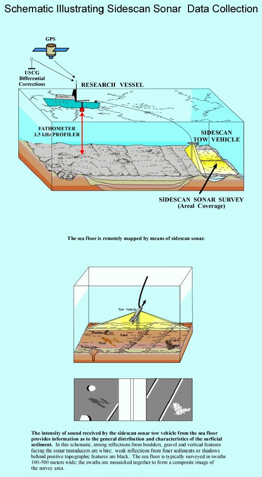
Bathymetric data, sidescan sonar imagery, and 3.5-kHz subbottom profiles were collected during November 7-11, 1993, aboard the research vessel (RV) JOHN DEMPSEY (operated by the Connecticut Department of Environmental Protection) along tracks spaced about 150 m apart (fig. 2). The bathymetric data were collected by using an Odem 60-kHz echo sounder, and the data were logged digitally on an IBM personal computer. The subbottom data were collected by using an Ocean Research Equipment 3.5-kHz subbottom profiler transmitting at a 0.25-s repetition rate. These data were logged in analog form on a paper chart recorder with examples shown in figure 3 and the interpretation summarized in figure 3. The sidescan sonar data were collected by using a 100-kHz Klein sidescan sonar system set to insonify a 100-m swath to either side of the ship's track. These data were logged digitally on a QMIPS data logger (Danforth and others, 1991) and were written to tape at 2048 pixels per scan. The completed sidescan mosaic is shown in figure 5 and an interpretation in figure 6. Ship's navigation was by differential Global Position System (GPS) using the shore station at Montauk Point, Long Island.
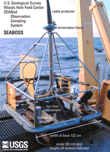
Surficial sediments were sampled and bottom photography was attempted at 77 locations during the April 26-30 and August 27-28, 1995, cruises aboard the RV JOHN DEMPSEY using a Van Veen grab sampler equipped with video and still camera systems (fig. 7). These photographic systems were used to appraise intra-station bottom variability and to observe boulder fields where sediment samples could not be collected. Surficial sediments (sediments from the sediment-water interface down to 2 cm below the interface) were subsampled from the grab sampler; these samples were frozen and stored for later analysis.
Post-cruise processing was performed on the digital data sets, and an interpretative geologic map was made of the analog 3.5-kHz subbottom profiles. The bathymetric data were corrected for the 2-m tidal range in the study area. This correction was done by subtracting the tide level measured at the Bridgeport, Conn., tide station during the study period from the measured depth values. The depths were corrected to mean sea level measured at Bridgeport, Conn.
The sidescan sonar data were processed, and a digital mosaic was compiled of the entire study area. The processing steps included subsampling the raw sidescan sonar data with a median filtering routine to suppress speckle noise (Malinverno and others, 1990; Danforth and others, 1991) and correcting for slant range distortion, signal attenuation, and dropped lines in the sonar data. These processing procedures are summarized by Danforth and others (1991) and Paskevich (1992a, b). After the preliminary processing, these data were used to make the composite digital mosaic. The mosaicking procedure included placing each strip of sonar data in its proper geographic location at the appropriate scale and projection (Paskevich, 1992c), trimming of unwanted data where two sonar images overlapped, tone matching the adjacent sonar images if there were differences, and combining the individual strips into a composite image. The final steps of trimming data, matching tones between different strips, and combining the strips was completed by using a software package developed by PCI (Nelson, 1991). The digital mosaic was output to film and photographically enlarged to a scale of 1:15,000.
In the laboratory, the textural samples were corrected for salt content, disaggregated, and wet sieved through a number 230, 62 micron (4 phi) sieve to separate the coarse and fine fractions. The fine fraction was analyzed by Coulter Counter (Shideler, 1976); the gravel fraction was analyzed by sieving and the sand fraction way analyzed by rapid sediment analyzer (Schlee, 1966). Because biogenic carbonates commonly form in situ, they usually are not representative of the depositional environment from a textural standpoint. Therefore, bivalve shells and other biogenic carbonate debris were manually removed from the gravel fraction. Size classifications are based on the method proposed by Wentworth (1929). The verbal equivalents were calculated by using the inclusive graphics statistical method (Folk, 1974) and were based on the nomenclature proposed by Shepard (1954). A detailed discussion of the laboratory methods employed is given in Poppe and others (1985); the raw grain-size data, associated statistics, and detailed descriptions of the bottom photography are reported in Poppe and others (1996).
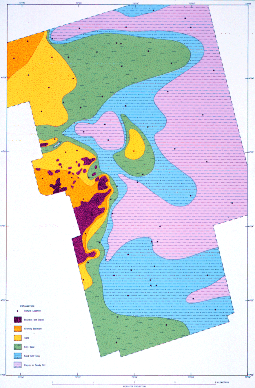
The map of surficial sediment distribution shown in figure 7 is based on data from the sediment sampling and bottom photography stations, on tonal changes in backscatter on the sidescan sonar image, and on the bathymetry.
The bathymetry was contoured at a 2-m interval (fig. 2). The sea floor in the eastern half of the study area has a smooth gradient that slopes uniformly to the south. Water depths along the northern edge of the study area are 14 to 20 m and along the southern edge are about 36 m. The western half of the study area has a more complex morphology. The gentle southerly gradient seen in the eastern part of the study area is interrupted by an elongate steep-sided depression and an irregular bathymetric high, Stratford Shoal (U. S. National Oceanic and Atmospheric Administration, 1992). The depression extends westward from the center of the study area beyond the extent of our data. Its 40 m depth is the deepest part of the study area and is 14 m deeper than the sea floor immediately to the east. Stratford Shoal, south of the depression, rises to 16 m depth in the west-central portion of the study area.
Near-surface Seismic Facies and Stratigraphy
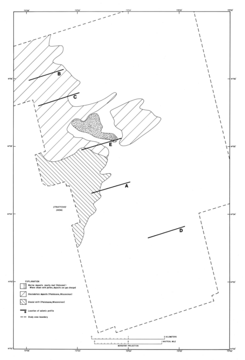
Three seismic facies were identified on the 3.5-kHz subbottom profiles (fig. 3): (1) a facies having a highly reflective and prolonged surface return with no subbottom reflections below it shown as drift on profiles A and E; (2) a facies having a moderately reflective and prolonged surface return with no subbottom reflections below it shown as glaciodeltaic deposits on profiles B, C, D, and E; and (3) an acoustically transparent facies having a moderately reflective surface return shown as marine deposits on profiles A, D, and E. In places the acoustically transparent facies is charged with gas and is acoustically opaque. The gas-charged sediments blank out everything below them (profile E).
The facies with the highly reflective and prolonged surface return is the oldest unit mapped in the study area. On the basis of the regional stratigraphy of Lewis and Stone (1991), this unit probably is glacial drift. The presence of fields of boulders on the sidescan mosaic where the drift crops out is consistent with this interpretation (figs. 5 and 6). Figure 3, profile E, shows that it underlies the facies with the moderately prolonged surface return, and figure 2, profile A, shows that it underlies the acoustically transparent facies as well. The 3.5-kHz profiles show that the drift is exposed on Stratford Shoal (fig. 4). It cannot be traced in the subsurface northward from Stratford Shoal under the depression, but it can be traced east from the limit of outcrop for 300 to 1,000 m under a 1- to 3-m-thick veneer of the acoustically transparent facies before it drops off abruptly to greater than 30 m below the sea floor (fig. 3, profile A).
The facies with the moderately reflective and prolonged surface return (fig. 3, profiles B, C, D, and E) crops out in the northwestern part of the study area where it extends southward to the northern edge of Stratford Shoal (fig. 4). The regional stratigraphy (Lewis and Stone, 1991) suggests that this facies is a sandy glaciodeltaic deposit that accumulated along the northern side of the Sound when it was occupied by Glacial Lake Connecticut. This unit is of unknown thickness because the 3.5-kHz subbottom profiling system could not penetrate it. This unit is younger than the drift because it onlaps the drift along the northern edge of Stratford Shoal (fig. 3, profile E).
The acoustically transparent facies is the youngest of the three units and overlies both the drift (fig. 3, profile A) and the glaciodeltaic deposits (fig. 3, profile D). This unit is interpreted to be a fine-grained marine deposit of Holocene age (Lewis and Stone, 1991). In the southeastern part of the study area, the thickness of the marine deposits could not be determined because the 3.5-kHz profiler could not penetrate below them. In most of the northern part of the study area, where the 3.5-kHz profiler could penetrate through the marine deposits, they are less than 8 m thick, and thin gradually to the west where the glaciodeltaic deposits crop out (fig. 4). Gas-charged sediment occurs in the marine deposits and is confined to the deepest part of the bathymetric depression in the central part of the study area (fig. 4).
The sidescan sonar mosaic (fig. 5) reveals nine distinctive sea-floor patterns, and when combined with the seismic data (fig. 2) can be used to make inferences about the surficial geology (fig. 5). The nine patterns include (1) low acoustic backscatter (dark tones), (2) high acoustic backscatter (light tones), (3) gas-charged sediment, (4) fields of positive relief high-backscatter targets interpreted to be clusters of boulders, (5) isolated high-backscatter targets interpreted to be individual boulders, (6) broad curvilinear low-backscatter stripes inferred to be bedforms, (7) circular depressions with high-backscatter floors, (8) short, linear high-backscatter stripes, (9) shallow, linear depressions interpreted to be trawl marks, and (10)long, thin, linear high-backscatter stripes interpreted to be pipelines and cables. Boat wakes are a water column phenomenon that were observed as well.
The study area is divided into two provinces, high and low acoustic backscatter (fig. 6). We set the boundary between these provinces to a digital number of 35 because the distribution of values exceeding a digital number of 35 coincides closely with the glaciodeltaic deposits and glacial drift as shown on figure 4. One exception is the outcrop of the glaciodeltaic deposits immediately east of the bathymetric depression where the area of high backscatter (figs. 5 and 6) is smaller than the extent of the outcrop seen on the near-surface echo character map (fig. 4). Perhaps there is a thin cover of marine deposits over much of this area that cannot be resolved on the 3.5-kHz profiles and is reducing the backscatter intensity below the threshold of 35.
The area of low backscatter on the sidescan image coincides with finer grained Holocene-aged marine deposits (fig. 7). The boundaries between the high- and low-backscatter regions are gradational, and backscatter intensity is not uniform throughout the low-backscatter area. The values are lowest in the deepest part of the bathymetric depression and coincide roughly with the distribution of gas in the sediment (figs. 5 and 6). The areas of higher backscatter probably indicate mixing with the adjacent or underlying coarser grained deltaic deposits.
The other features identified on the sidescan mosaic are found within either the high- or low-backscatter provinces. Boulders, bedforms, and trawl marks all are found in the high-backscatter province. Fields of boulders are limited in their occurrence to Stratford Shoal and its flanks (figs 5, 6, and 7), mostly where drift crops out (fig. 4). Isolated boulders are found in the low-backscatter province in a 300- to 1,000-m-wide apron around the area where the drift crops out. In this area, the 3.5-kHz profiles show a thin layer of marine deposits overlying the drift (fig. 2, profile) with the boulders being large enough to still stick through this cover. High-backscatter stripes, perhaps indicating current scour, occur in the low-backscatter province.
Shallow circular (<40 m in diameter) depressions with high-backscatter floors occur in the northern part of the study area (figs. 4 and 5), mostly in areas of low acoustic backscatter. Where the 3.5-kHz profiles cross them, there is no change in acoustic facies or relief. The origin of these features in unknown and needs to be addressed during subsequent studies in the area.
North- to northwest-trending linear to curvilinear, low-relief ridges are interpreted to be relict bedforms. These features are 1 to 2 m high, occur in a small area immediately north of the bathymetric depression, and tend to be asymmetrical with their steep sides facing east (fig. 3, profile C). The absence of smaller bedforms on the backs of these features (fig. 5) suggests that they are not actively moving under the present hydraulic regime.
Evidence of human activity also is present. A pipeline was clearly imaged by the sidescan (figs. 5 and 6) and subbottom (fig. 3, profile B) systems, and another continuous but fainter high-backscatter lineation may be smaller diameter pipe or cable. Trawl marks are most evident in the northwestern corner of the study area where the glaciodeltaic deposits crop out (fig. 4). Whether this association is because trawls show up more clearly in these sandy sediments than in the muddy ones or whether it is because these sandy sediments are a preferred habitat for what is being fished is unknown. Two types of dragging are observed on the sidescan image (figs. 5 and 6). Faint lineations that are several hundreds of meters in length and occur in near-parallel pairs are interpreted to be caused by trawl doors while shorter (<300 m in length) single lineations with low backscatter levee-like features to either side are caused by some other dredging process. One shipwreck that coincides with the location of one on the navigation chart (U.S. National Oceanic and Atmospheric Administration, 1992) is shown in the southern part of the study area.
Surficial Sediment Distribution
The locations of the sample and photographic stations are shown in figure 7. The distribution of boulders and gravel, which were observed on the sidescan image and at two of the bottom photography stations around Stratford Shoal, becomes more discontinuous around the northeastern portion of the shoal. The rocks at these stations were overgrown by hydrozoans and, to a lesser extent, by sponges. Gravelly sediments were confined to two shallow areas: the northwestern corner of the study area and the west-central part of the study area surrounding the boulders and gravel at Stratford Shoal. These gravelly sediments range from very poorly to extremely poorly sorted and are primarily fine skewed and leptokurtic.
As water depth increases, the gravelly sediments progressively grade into bands of sand and finer grained lithologies. The sands are poorly to very poorly sorted, finely skewed, and leptokurtic. The silty sands and sandy silty surrounding the coarser lithologies tend to have more symmetrical and mesokurtic to platykurtic distributions. Sandy silts present in the southern part of the study area reflect shallowing toward Long Island, New York. One exception to the relation between increasing water depth and the trend to finer grained lithologies occurs in and around the channel immediately north of Stratford Shoal where tidal currents are apparently strong enough to winnow away much of the silt and clay.
Sandy and silty clays and clayey silts dominate the deeper south-central (main axis of Long Island Sound), north-central (depression at the eastern end of the channel north of Stratford Shoal), and eastern portions of the study area. Clayey silts also collect in the slight depression north of a sandy shoal that extends eastward from the gravelly sediments present in the northwestern part of the study area. These fine-grained sediments are predominantly very poorly sorted and have nearly symmetrical to coarsely skewed distributions. The sandy and silty clays are mainly platykurtic, the clayey silts are primarily mesokurtic.
Observations of the bottom video reveal that benthic biologic activity and tidal currents are important mechanisms that combine to control the reworking and resuspension of bottom sediments. For example, while they feed crabs throw the fine-grained sediment directly up into the water column. Lobsters, shrimp, and crabs, as they burrow, often mound the sediments. Once these mounded sediments extend above the surrounding sea floor, they can be transported or reshaped by the strong tidal currents into the faint bedforms present in much of the bottom video.
The detailed view of the surficial geology of this part of Long Island Sound shows that it is closely related to the shallow subsurface stratigraphy. Areas of high acoustic backscatter mostly coincide with outcrops of coarser grained glacial drift and glaciodeltaic deposits. Boulders are found where drift is exposed on the sea floor or buried by only a thin sediment cover. The area of low acoustic backscatter coincides with the finer grained Holocene-aged marine deposits. High-backscatter stripes and high-backscatter depressions mostly fall within the area of the marine deposits. This detailed interpretation of the surficial geology based on the bathymetry, acoustic information, sampling, and bottom photography provides a base map for future studies of sedimentary processes and the interaction of biological, physical, and chemical activity at the sea floor in Long Island Sound.
We acknowledge the help of a number of people for the successful completion of this project. The skilled handling of the RV JOHN DEMPSEY by Peter Simpson, Miles Peterle, and Kurt Gottschall resulted in an extremely successful field program. We thank Dr. Anthony Calabrese, director of the National Oceanic and Atmospheric Administration's (NOAA) National Marine Fisheries Laboratory in Milford, Conn. for making space available for processing the sidescan sonar data while in the field. Valerie Paskevich aided in reformatting and transferring the sidescan sonar data to the image processing computer. Steve Gill of the Tidal Analysis Branch of NOAA provided the tide measurements from the tide station at Bridgeport, Conn., which were used to correct the bathymetry. Drafting was done by Jeff Zwinakis and photography by Dann Blackwood. This survey was originally published as US Geological Survey Geologic Investigations Series Map I-2632.
Danforth, W.W., O=Brien, T.F., and Schwab, W.C., 1991, USGS image processing system; Near real-time mosaicking of high-resolution side-scan SONAR data: Sea Technology, v. 32, p. 54-60.
Folk, R.L., 1974, The petrology of sedimentary rocks: Austin, TX, Hemphill Publishing Co., 182 p.
Fuller, M.L., 1914, The geology of Long Island, New York: U.S. Geological Survey Professional Paper 82, 231 p.
Lewis, R.S., and Stone, J.R., 1991, Late Quaternary stratigraphy and depositional history of the Long Island Sound basin, Connecticut and New York: Journal of Coastal Research, v. 11, p. 1-23.
Malinverno, Alberto, Edwards, M.H., and Ryan, W.B.F., 1990, Processing of SeaMARC swath sonar data: Institute of Electrical and Electronic Engineers Journal of Oceanic Engineering, v. 15, p. 14-23.
Moffett, A.M., Poppe, L.J., and Lewis, R.S., 1994, Trace metal concentrations in sediments from eastern Long Island Sound: U.S. Geological Survey Open-File Report 94-620, 17 p.
Nelson, L.J., 1991, An Aintelligent@ image database tool commercialized in Canada: Advanced Imaging, v. 6, no. 4, p. 56-58.
Paskevich, V.F., 1992a, Woods Hole Image Processing System software implementation; Using NetCDF as a software interface for image processing: U.S. Geological Survey Open-File Report 92-25, 66 p.
_______,1992b, Digital processing of side-scan sonar data with the Woods Hole Image Processing System software: U.S. Geological Survey Open-File Report 92-204, 9 p.
_______,1992c, Digital mapping of side-scan sonar data with the Woods Hole Image Processing System software: U.S. Geological Survey Open-File Report 92-536, 87 p.
Poppe, L.J., Eliason, A.H., and Fredericks, J.J., 1985, APSAS; An Automated Particle Size Analysis System: U.S. Geological Survey Circular 963, 77 p.
Poppe, L.J., Lewis, R.J., Zajac, R.N., Twichell, D.C., Schmuck, E.A., Parolski, K.F., and DiGiacomo-Cohen M.L., Sidescan sonar image, surficial geologic interpretation, and bathymetry of the Long Island Sound sea floor off Hammonasset Beach State Park, Connecticut: U.S. Geological Survey Geologic Investigations Map I-2588, 2 sheets, scale 1:7,500 and 1:15,000.
Rodgers, John, compiler, 1985, Bedrock geological map of Connecticut: Hartford, Conn.,Connecticut Geological and Natural History Survey, Connecticut Natural Resources Atlas Series, scale 1:125,000.
Schafer, J.P., and Hartshorn, J.H., 1965, The Quaternary of New England, in Wright, H.E., and Frey, D.G., eds., The Quaternary of the United States: Princeton, N.J., Princeton University Press, p. 113-128.
Schlee, John, 1966, A modified Woods Hole rapid sediment analyzer: Journal of Sedimentary Petrology, v. 36, p. 403-413.
Shepard, F.P., 1954, Nomenclature based on sand-silt-clay ratios: Journal of Sedimentary Petrology, v. 24, p. 151-158.
Shideler, G.L., 1976, A comparison of electronic particle counting and pipette techniques in routine mud analysis: Journal of Sedimentary Petrology, v. 46, p. 1017-1025.
Sirkin, L.A., 1982, Wisconsinan glaciation of Long Island, New York to Block Island, Rhode Island, in Larson, G.J., and Stone, B.D., eds., Late Wisconsinan glaciation of New England: Dubuque, Iowa, Kendall Hunt Publishing Co., p. 35-60.
Twichell, D.C., Zajac, R.N., Poppe, L.J., Lewis, R.S., Cross, V.A., Nichols, D.R., and DiGiacomo-Cohen, M.L., 1997, Sidescan sonar image, surficial geologic interpretation, and bathymetry of the Long Island Sound sea floor off Norwalk, Connecticut: U.S. Geological Survey Geologic Investigations Map I-2589, 2 sheets, scale 1:15,000.
U.S. National Oceanic and Atmospheric Administration, 1992, Long Island Sound - Eastern part: U.S. National Oceanic and Atmospheric Administration Chart 12354, scale 1:80,000.
Wentworth, C.K., 1929, Method of computing mechanical composition of sediments: Geological Society of America Bulletin, v. 40, p. 771-790.
Figure 1. Location map showing the study area in Long Island Sound off Milford, Conn and major onshore moraines. Also shown are the sites of other sidescan sonar surveys completed to date as part of this series [Norwalk-Twichell and others (1997); Hammonasset-Poppe and others (1997); New London-Poppe and others (1992) and Moffett and others (1994)].
Figure 2. Bathymetric map of the study area. Depths have been corrected for tides and are adjusted to mean sea level. Dashed lines represent tracks along which geophysical data were collected.
Figure 3. Subbottom profiles (3.5-kHz) showing the different echo character types mapped in figure 3. Profiles A and E show the acoustically prolonged facies, interpreted to be glacial drift deposits; profiles B and C show the moderately prolonged facies, interpreted to be glaciodeltaic deposits; profile D shows the acoustically transparent facies, interpreted to be fine-grained Holocene deposits; and profile E shows the stratigraphic relation of the three facies as well as the acoustically opaque facies, interpreted to be the gas-charged sediment. Profile locations are shown in figure 3. VE, vertical exaggeration.
Figure 4. Near-surface echo character map compiled from the 3.5-kHz subbottom profiles showing the distribution of the three acoustic facies that were defined by the subbottom profiles.
Figure 5. Sidescan sonar mosaic of the study area. Dark tones on the image represent areas of low acoustic backscatter, and light tones represent areas of high acoustic backscatter.
Figure 6. Interpretation of the sidescan sonar mosaic. The patterns defined in the explanation are discussed in the text.
Figure 7. Map showing the distribution of surficial sediments and the locations of the sediment sampling and bottom photography stations. Interpretations of the sediment distribution is based on data from these stations, on tonal changes in backscatter on the sidescan sonar image (fig. 4), and on the bathymetry (fig. 1). The patterns defined in the explanation are discussed in the text.
Figure 7c. Color version of figure 7.
The sidescan-sonar mosaic is a digital image with a 1-m pixel size ( a pixel represents one meter on the sea floor). The 14Mbyte digital image is available for viewing as a graphic in "tif" format with its associated Arcview geo-reference world file.
[an error occurred while processing this directive]