Robert B. Finkelman and Susan J. Tewalt
U.S. Geological Survey Open-File Report 98-0772
[ Map | References | Table ]
On February 24, 1998 the U.S. Environmental Protection Agency (EPA) issued a report citing mercury emissions from electric utilities as the largest remaining source of mercury to the air (EPA, 1998a and b). Based on 1994 information, the EPA estimates that about 51 tons of mercury are emitted each year from coal-burning power plants, lesser amounts coming from oil- and gas-burning units. The EPA estimates that emissions from coal-fired utilities account for 13 to 26 percent of the total (natural plus anthropogenic) airborne emissions of mercury in the U.S. The EPA concludes that "utility mercury emissions are of sufficient potential concern for public health to merit further research and monitoring".
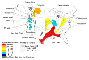
For the past twenty years the USGS has been conducting research on the distribution of mercury in U.S. coal and has compiled information on the concentration of mercury in more than 7,000 complete coal bed samples (the COALQUAL database). The mean values for mercury in the coals of the major coal basins in the U.S. are presented in the associated figure and table, expressed on a pounds per trillion Btu basis. Moisture differences between the coals in the different basins, which are dependent on the rank of the coal, have not been factored into these values nor have the effects of physical coal cleaning. The USGS is also gathering information on the mercury content of coal being mined and burned in other major coal-producing countries and is conducting research to elucidate the forms of mercury in coal and its behavior during coal cleaning and combustion. [ Top ]
EPA (Environmental Protection Agency), 1998a, Mercury emissions and electric utilities. February 24, 1998.
EPA (Environmental Protection Agency) , 1998b, Mercury study report to Congress: White Paper. February 24, 1998.
Bragg, L.J., Oman, J.K., Tewalt, S.J., Oman, C.L., Rega, N.H., Washington, P.M., and Finkelman, R.B., 1994, U.S.Geological Survey Coal Quality (COALQUAL) database: version 1.3, USGS Open-file Report 94-205 (CD-ROM). [See OF 97-134.]
Tully, John, 1996, compiler, Coal Fields of the United States: USGS Open-file Report 96-92, digital version.
TABLE 1: Mean Values for Samples in Selected Coal Areas: Ash Yield (%), Calorific Value (Btu/lb), Total Moisture (%) and Mercury (Remnant Moisture) on Equal energy Basis (lb /1012Btu). Conversion to metric: Btu/lb X 2324.4 = J/kg
As-received Basis
Coal Area |
No. of Samples |
Ash Yield % |
Calorific Value Btu/lb |
Total Moisture % |
Mercury lb/1012Btu |
| Appalachian | 4,186 |
10.9 |
12,790 |
3.3 |
15.4 |
| Eastern Interior | 265 |
10.9 |
11,440 |
8.5 |
8.2 |
| Fort Union | 277 |
9.2 |
6,360 |
36.9 |
21.8 |
| Green River | 293 |
10.8 |
9,580 |
15.4 |
6.6 |
| Gulf Coast | 111 |
12.8 |
6,490 |
34.8 |
36.4 |
| Hams Fork | 25 |
10.1 |
10,570 |
12.1 |
4.8 |
| PA Anthracite | 40 |
13.4 |
12,440 |
2.4 |
15.4 |
| Powder River | 492 |
7.6 |
8,090 |
28.0 |
12.6 |
| Raton Mesa | 34 |
15.5 |
12,320 |
2.2 |
6.6 |
| San Juan River | 175 |
16.3 |
9,610 |
12.4 |
7.7 |
| SW Utah | 42 |
12.4 |
9,290 |
17.0 |
11.0 |
| Uinta | 232 |
10.2 |
10,800 |
11.0 |
7.3 |
| Western Interior | 328 |
5.9 |
10,970 |
8.9 |
16.1 |
| Wind River | 42 |
11.0 |
9,560 |
16.8 |
18.7 |
Disclaimer: This report is preliminary and has not been edited or reviewed for conformity with U.S. Geological Survey standards.
Created by the EERT WWW Staff.
[an error occurred while processing this directive]