
With a preface by Earl E. Brabb and Richard J. Pike
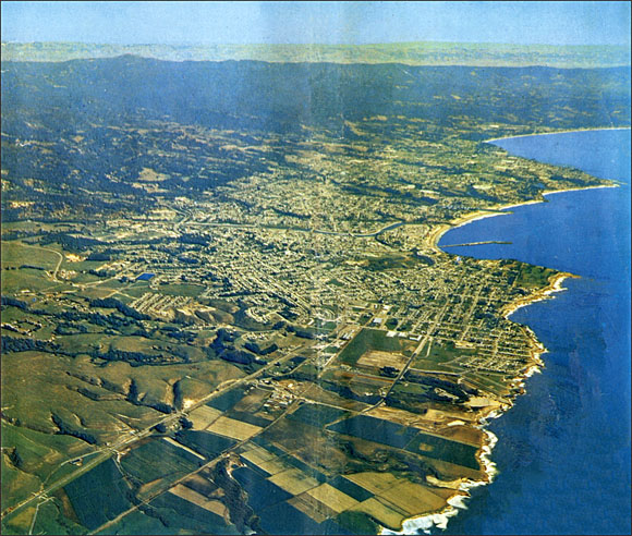
Aerial photograph of Santa Cruz, California, looking east from over Wilder Ranch State Park. Most of the city is built on a series of elevated marine terraces. Landslides are common in the uplands and along the seacoast cliffs, developing in the soft, heavily fractured Tertiary sedimentary rocks covering much of the area.
Files available for downloading:
View the revision list as an unformatted, text-only file: of98-792revs_1a.txt (4 kb).
View the database explanation pamphlet as an unformatted, text-only file: of98-792_2a.txt (46 kb).
Download the database explanation pamphlet as a formatted PostScript plot file: of98-792_2b.ps (745 kb).View the database explanation pamphlet as a formatted PDF file: of98-792_2c.pdf (70 kb)
DATA
Digital databases are available for GIS users in ARC/INFO format. Those downloading digital data should also download the descriptive
pamphlet. Some of the data have been archived as tar files, and most are compressed with gzip. File sizes (in parentheses) are for the gzip-compressed download file.
To download the database for large landslide deposits, select one of the following quadrangles:
Mindego Hill of98-792_3a.e00.gz (24 kb).
Cupertino of98-792_3b.e00.gz (8 kb).
Franklin Point of98-792_3c.e00.gz (78 kb).
Big Basin of98-792_3d.e00.gz (219 kb).
Castle Rock Ridge of98-792_3e.e00.gz (197 kb).
Los Gatos of98-792_3f.e00.gz (25 kb).
Ano Nuevo of98-792_3g.e00.gz (54 kb).
Davenport of98-792_3h.e00.gz (248 kb).
Felton of98-792_3i.e00.gz (214 kb).
Laurel of98-792_3j.e00.gz (384 kb).
Loma Prieta of98-792_3k.e00.gz (146 kb).
Mount Madonna of98-792_3l.e00.gz (10 kb).
Santa Cruz of98-792_3m.e00.gz (77 kb).
Soquel of98-792_3n.e00.gz (34 kb).
Watsonville West of98-792_3o.e00.gz (86 kb).
Watsonville East of98-792_3p.e00.gz (146 kb).
Chittenden of98-792_3q.e00.gz (19 kb).
To download the database for annotation on large landslides and downslope movement arrows, select one of the following quadrangles:
Mindego Hill of98-792_4a.e00.gz (1 kb).
Cupertino of98-792_4b.e00.gz (0.9 kb).
Franklin Point of98-792_4c.e00.gz (5 kb). Big Basin of98-792_4d.e00.gz (20 kb).
Castle Rock Ridge of98-792_4e.e00.gz (14 kb).
Los Gatos of98-792_4f.e00.gz (2 kb).
Ano Nuevo of98-792_4g.e00.gz (2 kb).
Davenport of98-792_4h.e00.gz (24 kb).
Felton of98-792_4i.e00.gz (19 kb).
Laurel of98-792_4j.e00.gz (26 kb).
Loma Prieta of98-792_4k.e00.gz (12 kb).
Mount Madonna of98-792_4l.e00.gz (1 kb).
Santa Cruz of98-792_4m.e00.gz (3 kb).
Soquel of98-792_4n.e00.gz (1 kb).
Watsonville West of98-792_4o.e00.gz (3 kb).
Watsonville East of98-792_4p.e00.gz (10 kb).
Chittenden of98-792_4q.e00.gz (1 kb).
To download the database for small landslide deposits, select one of the following quadrangles:
Mindego Hill of98-792_5a.e00.gz (3kb).
Cupertino - No small landslide layer is available.
Franklin Point of98-792_5c.e00.gz (3kb).
Big Basin of98-792_5d.e00.gz (7 kb).
Castle Rock Ridge of98-792_5e.e00.gz (17 kb).
Los Gatos of98-792_5f.e00.gz (2 kb).
Ano Nuevo of98-792_5g.e00.gz (4 kb).
Davenport of98-792_5h.e00.gz (9 kb).
Felton of98-792_5i.e00.gz (8 kb).
Laurel of98-792_5j.e00.gz (11 kb).
Loma Prieta of98-792_5k.e00.gz (11 kb).
Mount Madonna of98-792_5l.e00.gz (3 kb).
Santa Cruz of98-792_5m.e00.gz (6 kb).
Soquel of98-792_5n.e00.gz (5 kb).
Watsonville West of98-792_5o.e00.gz (18 kb).
Watsonville East of98-792_5p.e00.gz (6k kb).
Chittenden of98-792_5q.e00.gz (4 kb).
To download ARCVIEW shapefiles, select one of the following quadrangles:
Mindego Hill of98-792_6a.tar.gz (31 kb).
Cupertino of98-792_6b.tar.gz (8 kb).
Franklin Point of98-792_6c.tar.gz (153 kb).
Big Basin of98-792_6d.tar.gz (489 kb).
Castle Rock Ridge of98-792_6e.tar.gz (439 kb).
Los Gatos of98-792_6f.tar.gz (31 kb).
Ano Nuevo of98-792_6g.tar.gz (116 kb).
Davenport of98-792_6h.tar.gz (558 kb).
Felton of98-792_6i.tar.gz (483 kb).
Laurel of98-792_6j.tar.gz (810 kb).
Loma Prieta of98-792_6k.tar.gz (317k kb).
Mount Madonna of98-792_6l.tar.gz (10 kb).
Santa Cruz of98-792_6m.tar.gz (179 kb).
Soquel of98-792_6n.tar.gz (56 kb).
Watsonville West of98-792_6o.tar.gz (197 kb).
Watsonville East of98-792_6p.tar.gz (334 kb).
Chittenden of98-792_6q.tar.gz (26 kb).
SUPPORTING FILES
Supporting file for ARC/INFO use. When extracted, this contains a file to convert ARC export coverages, and files to convert between UTM and state plane projections:
of98-792_7a.tar
QUADRANGLE INDEX DATABASE
ARC export coverage of98-792_8a.e00.gz (21 kb).
Arcview shape files of98-792_8b.tar.gz (22 kb).
PLOTFILES
Plotfiles are available for those who wish to produce paper copies of maps prepared from the digital data. These maps have been edited to conform as much as possible to standard U.S. Geological Survey format for geologic maps. The plotfiles are in PostScript format. Note that these plotfiles are formatted to plot on 34 by 34 inch or larger sheets, so a large format color plotter is required to produce a paper map. Alternatively, some software can import PostScript files, allowing the user to manipulate the map image as desired. Those who download plotfiles should also download the descriptive
pamphlet. (46 kb).
To download the plotfile in PostScript format, select one of the following:
Entire county of98-792_9a.ps.gz (5.8 MB download; 27 MB uncompressed).
To download the plotfile in PDF format (uncompressed), select the following:
Entire county of98-792_9b.pdf (5.4 MB).
For questions about the scientific content of this report, contact Earl Brabb
Download a free copy of Adobe Reader
USGS Information Services
Box 25286 Federal Center
Denver, CO 80225
Telephone: 1-888-ASK-USGS
E-mail: infoservices@usgs.gov
| Help
| PDF help |
| Publications main page
| Open-file reports [on line] |
| Department of the Interior
| U.S. Geological Survey |
| Geologic Division
| Western Earth Surface Processes Team |
| Privacy Statement
| Disclaimer
| Accessibility |
The URL for this page is:
https://pubs.usgs.gov/of/1998/of98-792/
Please send comments and suggestions, or report problems, to:
Michael Diggles
Updated: October 7, 2009
(bwr, mfd)