| Environmental Geochemistry and
Sediment Quality in Lake Pontchartrain |
Geophysical surveys
High Resolution Seismic Profiling-
Objectives and Accomplishments:
High resolution Seismic Profiling (HRSP) provides a means to remotely image subsurface
features continuously and relatively easily. Resolution is about one meter and extends to
about 1 km depth. Unlike land based seismic-reflection techniques, marine HRSP is acquired
continuously, greatly reducing post-processing. HRSP provides continuous two dimensional
profiles, whereas invasive techniques such as borehole drilling can only be inferred
through correlation between boreholes. HRSP is also more cost effective at depth than
drilling. Remote sensing is subjective, however, and without close correlation to direct
sediment sampling, characteristics such as lithology and texture can only be assumed.
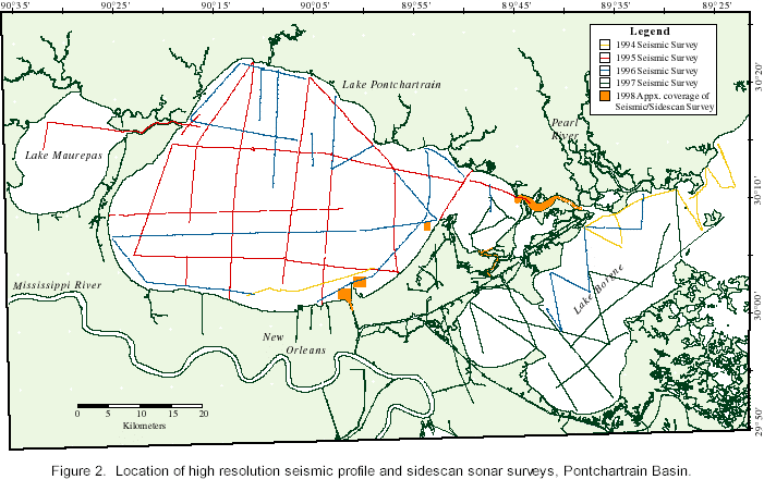
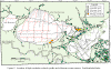
| Since
1994, over 650 line-kilometer of HRSP have been obtained, tied to Differential Global
Positioning System (DGPS) navigation (Fig. 2). The
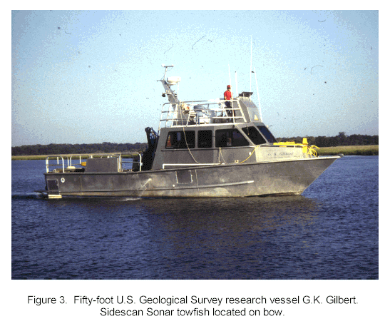
surveys were conducted aboard the USGS research vessel G. K. Gilbert (Fig. 3). In 1994, the effort was to establish a
reconnaissance gridwork of Lake Pontchartrain. In addition, one line was run through Pass
Manchac into Lake Maurepas. The following year reconnaissance lines were run off of the
Pearl River and Rigolets area and one line along the southeastern shore of Lake
Pontchartrain. In 1996 transects were run to fill in gaps left by previous surveys and to
provide insight into issues brought up by interpretations of the earlier surveys and
sediment core samples. Further reconnaissance along the Rigolets area of Lake Borgne was
included. The effort in 1997 was complete coverage in easternmost Lake Pontchartrain and
Lake Borgne, and to tie together core transects obtained the previous year. In 1998
efforts were focused on a series of dredge pits located on the south shore of Lake
Pontchartrain in conjuction with side scan sonar surveys (described below). Additional
surveys were conducted in the Rigolets and Chef Menteur passes. |
Figure 2:
|
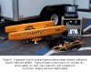
| Figure 3:

|
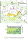
| Figure 4:
|
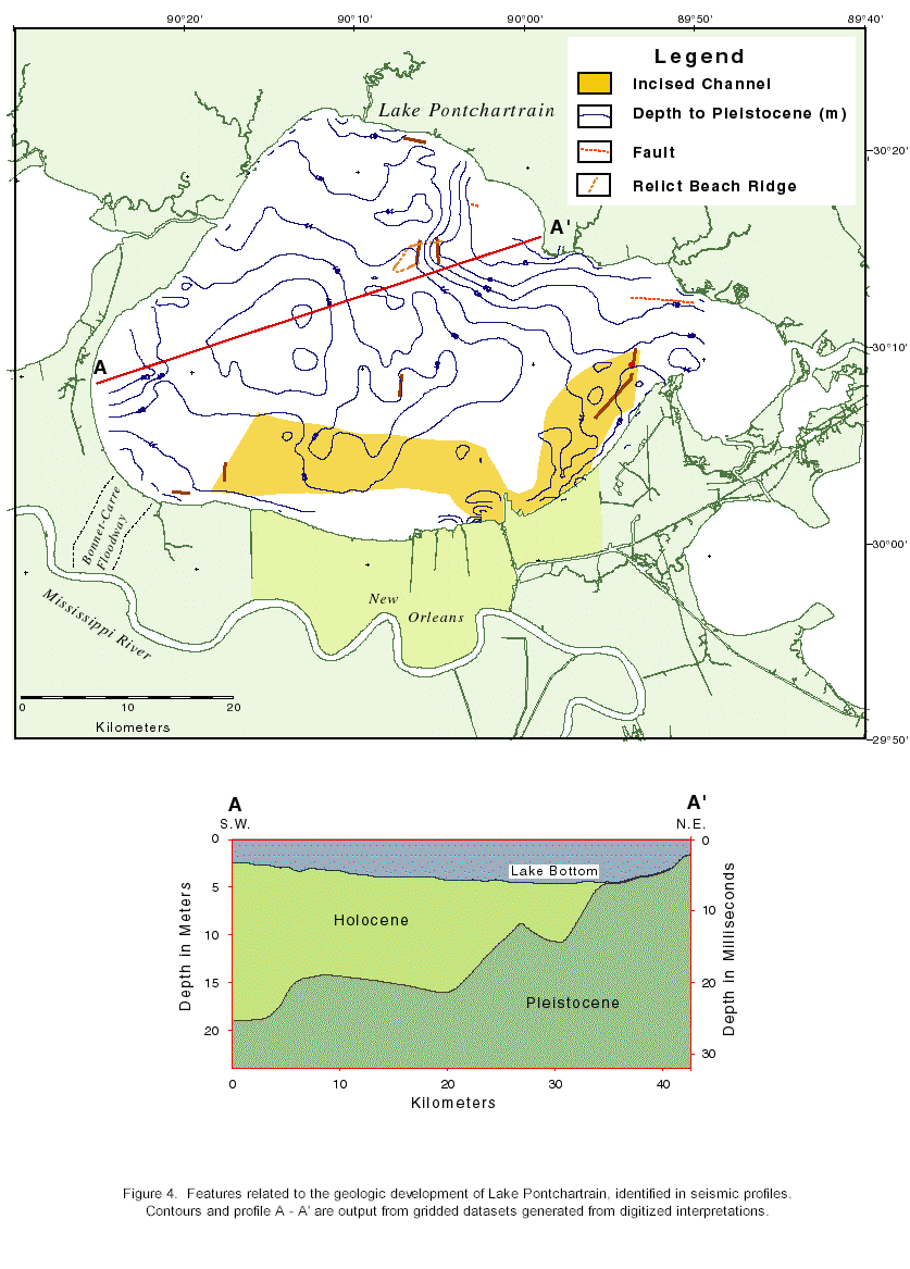
The task objective for the HRSP surveys was to establish a
recent (Quaternary) geologic framework for the basin through interpretation of the seismic
profiles and their correlation with invasive field investigations. Current accomplishments
using the HRSP include: a.) the identification and location of subsurface features such as
faults, barrier trends, paleo-deltas and paleo-incised valleys throughout the basin, and;
b.) resolve the spatial distribution of various regional geomorphologic features such as
the unconformable contact between Pleistocene and Holocene sediments (Fig. 4) and the transitional relationship between open and
closed-basin sediments during the Late Wisconsin sea-level rise. Contacts are verified
through correlation with direct sampling techniques, such as vibracoring. |
Method:
| High resolution, single channel seismic profiles were acquired
using the Elics Delph 2 system, running in real time on a Kontron Electronics IP Lite
laptop computer. Hard-copy data was displayed using a gray scale thermal plotter with
digital data backed up on removable 1 Gigabyte hard disks. Navigation data was collected
using a PLGR (Rockwell) GPS receiver with Geolink mapping software (Fig. 5). |
Figure 5:
 |
The acoustic source was a Huntec Model 4425 Seismic Source
Module which triggered an electromechanical device deployed on a catamaran sled. Power
settings ranged from 60 to 265 joules depending upon conditions. An Innovative Transducers
Inc. ST-5 multi-element hydrophone was used to detect the return acoustical pulse. This
pulse was fed directly into the Elics Delph 2 system for storage and processing.
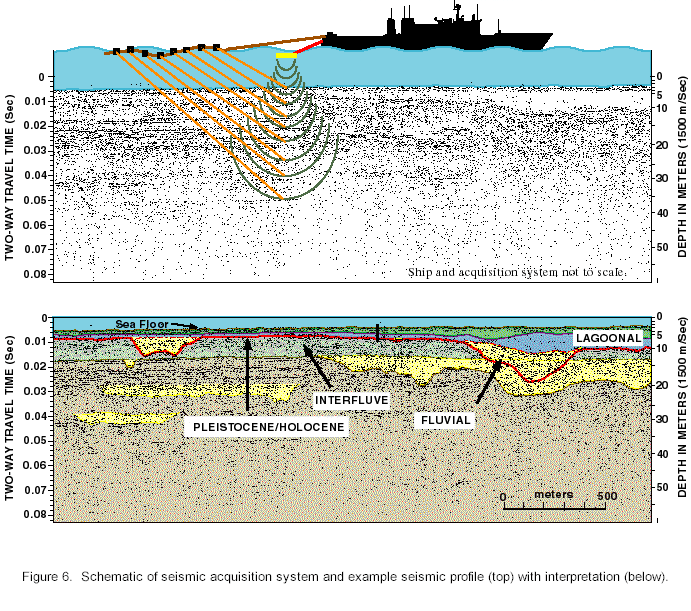
Figure 6:
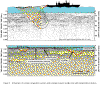 |
The Elics Delph 2 system measures and displays two-way travel
time (TWTT) of the acoustical pulse in milliseconds (ms). Amplitude and velocity of the
signal are affected by variations in lithology of the underlying strata. Laterally
consistent amplitude changes (lithologic contacts) are displayed as continuous horizons on
the seismic profiles (Figure 6). Depth to horizon is
determined from the TWTT, adjusted to the subsurface velocity of the signal. An averaged
compressional velocity of 1500 meters per second was used. |
Reflective horizons on the seismic profiles were correlated
to stratigraphic horizons based on corroboration with invasive techniques, previous
studies, and the development of the geologic framework of the Basin. The horizons were
mapped out on paper copies and digitized using conventional table-top digitizing
techniques. Navigation was tied to each digitized point using a FORTRAN program that
interpolated geographic coordinates between navigational fixes. The resulting, latitude,
longitude and depth to horizon coordinates for an interpreted horizon, for all the
profiles digitized, were combined and gridded using the commercial software package CPS-3.
From the gridded data set contour maps of the interpreted horizon were developed using the
same software.
|