
| Environmental Geochemistry and
Sediment Quality in Lake Pontchartrain |
Sea Surface Temperature Images
These images of Lake Pontchartrain, Louisiana, were derived from data collected by the
Advanced Very High Resolution Radiometer (AVHRR) onboard NOAA polar-orbiting weather
satellites. Sea Surface Temperature is derived from thermal infrared wavelengths using
standard algorithms developed by NOAA. These values have not been validated. Clouds are
masked in gray; land in brown.
 Back to Lake Pontchartrain Basin Imagery
|
 February 20, 1995
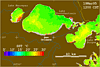 March 19, 1995
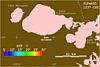 February 21, 1995
 May 2, 1995
 March
9, 1995
March
9, 1995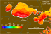 May 5, 1995
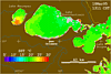 March 18, 1995
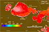 May 15, 1995