The Labranche Wetlands
In the LaBranche Wetlands your students conduct water quality monitoring activities at a boat launch, and from there you travel along the road adjoining the railroad. This embankment provides an excellent vantage point across the marsh. You see abundant wildlife and learn to identify the four wetland habitats in LaBranche. You can also see some erosion damage as well as restoration projects designed to repair the damaged wetlands.
St. Bernard Wetlands
The theme of this field trip is "pollution solution." The location is e Gore Pumping Station situated on the hurricane protection levee in St. Bernard Parish. The first thing you notice as you arrive is an area of very unhealthy cypress swamp in which the majority of trees look dead at least at first glance. However, your students learn that an innovative method of regenerating this swamp is being tried. It involves pumping treated discharge from the nearby sewage treatment plant, along with stormwater, into the swamp. At first this may not sound like a solution, but further investigation reveals that the swamp near the pumping station is healthier than the swamp which is further away. Your students monitor chemical and biological parameters and analyze the implications - that nutrients from the sewage plant and urban runoff are actually benefiting the vegetation of the swamp. In addition the freshwater pumped into the wetland is helping to offset the effects of intrusion of salty water from the Mississippi River Gulf Outlet (MRGO), the major culprit of the disintegration of the St. Bernard Wetlands.
Turtle Cove
Turtle Cove Environmental Research Station is situated on the banks of Pass Manchac, deep in the wetlands. Southeastern Louisiana University provides boat transport to the field house for the groups. There your students can truly experience the Louisiana wetlands far from urban clutter. A staff member gives a slide presentation overview of the ecology and history of this fascinating area, after which you are given a tour of the facility. A boardwalk provides a safe observation point from which you learn about the ecology of the area and some of the research being conducted in the marsh. You also encounter wildlife such as turtles, snakes, and alligators. Your students have the opportunity to do their own aquatic sampling using dip nets and plankton nets. You can request the use of microscopes to observe the organisms caught. You may also wish to bring other sampling equipment from your school. In good weather you can all travel on the pontoon boat into Lake Pontchartrain, spotting bald eagles, osprey and other wildlife along the way.
Wetland Activites
| Journal Writing: |
Ask the students to keep a journal recording their impressions and observations during the trip. Their notes can be brief just "memory joggers" such as names of birds with a couple of descriptive words or a sentence describing something that impressed them. The artistic students may want to sketch their observations.
As an extension of this activity the students can research an issue or topic that particularly caught their attention. In class next day, you can brainstorm the topics with the class and let them pick their favorite from the list. To prepare for this activity you may want to collect information about the issues encountered on the trip from one of the resources listed at the end of this section. After doing their research, the students can present their findings to the class, using visual aids, such as photos or videos taken on the field trip, to enhance the presentation.
| Guided Imagery: |
The swamps of south Louisiana were clearcut for cypress lumber early in the 20th Century. Cypress loggers, however, did not replant. In most areas of Louisiana the cypress grew back after logging, but in some areas the trees failed to regenerate. This is the case at Turtle Cove. The following excerpt is from a book written about the Atchafalaya, but it could have taken place in the Pontchartrain Basin where cypress logging took place, including Turtle Cove, the St. Bernard swamps and the LaBranche Wetlands.
Tell the students to close their eyes and concentrate on visualizing what is described in the passage you are reading:
From The Land of Dead Giants by Greg Guirard
At that time logging crews lived in floating camps and didn't come out of the woods for weeks at a time; it was a rough life. One morning, when the crew was nearing the end of its work in that area, they came upon a cypress tree that was considerably bigger and taller than the resta giant among giantsand the men looked at it with wonder; none of them had ever seen a tree that size. They delayed cutting the tree, which was near the center of a small clearing in the swamp, purposely leaving it for last.
Because it was not badly crowded by the other trees, it had grown straight and tall, and its massive branches extended far out in all directions. Like many of the biggest trees, this one served as home for all kinds of birds and animals. Squirrels ran and jumped from branch to branch. Raccoons hid behind moss and leaves, peeking down on the men as they worked the saws and axes, always coming closer. Owls perched on the lower branches, watching quietly. Hawks on the topmost branches looked over a scene totally unfamiliar to them miles and miles of trees that had always towered to great heights above the swamp floor now lay flat and useless. Egrets and ibis came and went nervously, and songbirds with no other trees to land on filled the branches of this last tree. The air itself around the giant cypress was a swarm of birds and butterflies.
- After reading the passage to the students, discuss the scene with them; ask them how they feel about the logging of the cypress trees.
- Explain that later in the story one of the loggers tries to persuade the company boss to leave this giant tree standing. Ask the students what they would do in this situation. The students can role play the loggers, discussing the fate of the tree and the pros and cons of sparing this tree.
- Ask the students to describe the scene from the viewpoint of the hawks looking "over a scene totally unfamiliar to them."
- The students can also draw the scene of the giant tree in the passage.
| Concept Mapping: |
Concept maps or graphic organizers are an excellent way to help students rearrange complex information in a meaningful way; they also enhance comprehension and retention. The following is an example of a "concept mapping" lesson.
Blue Crab
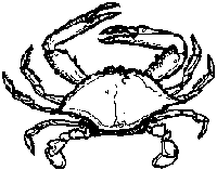
The blue crab is a very important component in the food web of the marsh in the Pontchartrain Basin. But let's not forget that we also are part of that food web. When the blue crabs are harvested they enter another web of human making--the economic web. The crabber harvests the crabs to make a living. When we eat crab in gumbo at our favorite restaurant, many people's economic well -being is affected directly and indirectly by the crabs in the gumbo.
Ask the students to list questions about the details of the blue crab and the crabbing industry and research the answers. Once they have facts and figures, teach them how to make a concept map by following these steps:
- Share example of concept map with the class so they understand the goal of the activity (sample concept map).
- Write "Blue Crab" in the center of an easel pad or on the chalk board.
- Ask the students to brainstorm all the facts and ideas that they have learned or thought about while doing their research.
- After all the ideas are listed, group the students and have each group cluster the ideas into like groups or categories and create a finished concept map.
The finished concept map should show all the relationships between and among the components. There is no right or wrong way to do a concept map. There will probably be as many forms of concept maps as there are groups! It's fun to display and compare all the results. The students learn from each other this way.
| Map Skills: |
All four of the wetlands field trips lend themselves to fascinating map study. It is essential that the students get to look at a map of the area they are visiting to gain a sense of place and to understand how the area fits into the Lake Pontchartrain Basin. Maps and aerial photography contain a wealth of information.
- The Lake Pontchartrain Basin Foundation has maps.
- New Orleans Map Company is an excellent source of maps.
- The public library has maps.
- State agencies such as the Louisiana Geological Survey, the Department of Natural Resources and the Department of Wildlife and Fisheries also have divisions that specialize in mapping and can supply satellite images and aerial photography of the Pontchartrain Basin.
Aerial photographs of LaBranche show both the damage caused by the construction of the interstates, 10 and 310, as well as restoration projects. Aerial photographs and maps of St. Bernard show the impact of the Mississippi River Gulf Outlet; aerial photography of the Turtle Cove area reveals the intricate pattern of logging canals.
A map or aerial photograph could become the centerpiece of a display about the field trip.
| Interviews: |

The students can gather a great deal of real- life information as well as historical facts by terviewing community members who are well acquainted with some aspect of the wetland area they visit. Question preparation time is crucial. The students should decide in advance what information they want: for example, the changes fishers have experienced over the years, the effects of erosion, and restoration efforts on the wetlands. Invite the interviewee to the classroom and structure the visit like a panel discussion, with a student moderator, a student speaker, and questions from the audience. Each student should prepare one question in advance. The students can record the interview on audio or video tape.
To process the information gathered from the interview, cooperative groups of students can prepare news reports. They:
(a) review and discuss information from the interview;
(b) brainstorm;
(c) create a graphic organizer or concept map of the information gathered;
(d) use a segment of the interview in either a TV news cast or a written newspaper story.
| Water Quality Monitoring: |
Salinity is the most important factor in determining habitat types in the coastal wetlands. Students of the Pontchartrain Basin should understand that they live in an estuary! By looking at salinity and its effects, they gain an insight into the relationship between the salt water of the Gulf of Mexico, the fresh water draining from the high ground, and the brackish water where the two mix. When the students get a result from monitoring water quality, expressed in parts per thousand, the investigation has just begun! They can now begin to question the meaning and implications of their results.
- How does the salinity of their water sample compare to the water in the Gulf?
- Does the level of salinity found in their water sample have an impact on living things in the area?
- Are the plants and animals in the area well adapted to this salinity?
- If there is a salt water intrusion problem, what are some possible solutions?
- Is the salinity at this sampling station the same as another station in the immediate area? Why or why not?
Dissolved Oxygen levels give us an indication of the water's capacity to support life. Fluctuations in dissolved oxygen levels can cause stress in aquatic environments. Research and water quality monitoring inform the students about "dead zones" and fish kills which are the result of low oxygen content and which have serious implications. The students obtain a result from this test in parts per million; then convert it to percent saturation. This measure is a guide to the relative health of the water body. Students can then relate this result to other factors such as: air temperature, water temperature, weather conditions, stagnation of the water, growth and death cycles of the aquatic plants, decay of dead material, and so on.
Nitrates and Phosphates are two nutrients that cause problems in Lake Pontchartrain if there are excessive amounts of them. The students will see the positive effects of nutrients and will also learn about the negative effects of too many nutrients entering the water from urban runoff. By measuring the levels of nitrates and phosphates in the water and comparing their result with the EPA -directed acceptable levels, the students can assess the situation. Following the investigation, students can discuss and research sources of excess nutrients as well as brainstorm ways we can reduce the nutrient load from our urban areas. The students can conduct further research when they get back to school about the connection between nutrients and dissolved oxygen levels.
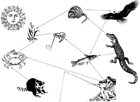
| Food Web Game: |
A great way to reinforce concepts about "who eats whom" in the wetland food web is to make cards with the names of all the organisms (plants, animals, and microbes) you encountered on your field trip or in the course of your research. You will also need a "sun" card.
The students make the cards and play a food web game in which:
- They "become" an organism, wearing their cards around their necks;
- Different colored yarn is passed from student to student, beginning with the student wearing the "sun" card, moving to one wearing a "producer" (green plant) card, then to a student wearing a "primary consumer" (herbivore) card, then to one who is a "secondary consumer" and so on.
- Don't forget to include "detritivores," "decomposers," and "scavengers," of which there are many in the wetlands.
- The first time you play the food web game there may be more questions than answers, and some research may be necessary before you can play the game successfully.
- This game is a great opportunity to analyze the food web of the region in which you and your students live. You will want to ask your students questions such as: "What if all the shrimp disappeared?" or "What if there were half the number of producers?" Simulate the results.
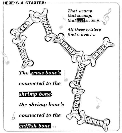
| Wetland Foodweb Songs: |
The fascinating array of wildlife encountered on a wetland field trip can generate creative sparks among your students. How about challenging the students to come up with a song to the tune of the old song "Dem Bones". This will work best after doing the Wetland Web game in which the students become familiar with the food web possibilities.
Alternatively, or in addition, the students might enjoy learning "Wetland Blues Ode", reprinted here from (Banbury, M.M., Lyons, S. E., Cain, M.A., Rivera, D.B., & Alonzo, S. F. (1992). Wetland Blues: A Video Guidebook for Teachers. New Orleans: Society for Environmental Education, p. 32). After watching the video "Wetland Blues"(Resource: Urban Waste Management and Research Center at the University of New Orleans), the whole class can memorize and sing the song which introduces many wetland names and themes in a fun way.
Wetland Blues Ode
|
Redfish, Blue Crab, White Shrimp, Black Duck (Faster)
Alligator, Garfish, Lily Pad, Food Chain (Music)
Green Fern, Laughing Gull, Least Tern, Scud (Faster)
Rockweed, Horsefly, Oak Seed, Water Snake |