Open-File Report 99-7-B
EXECUTIVE SUMMARY
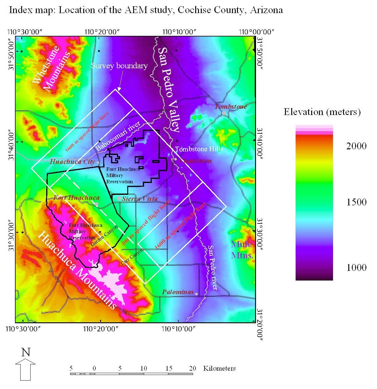
In March of 1997, an airborne electromagnetic (AEM) survey of the Fort Huachuca Military Reservation and immediate surrounds (location map) was conducted. This survey was sponsored by the U.S. Army and contracted through the Geologic Division of the U.S. Geological Survey (USGS). Data were gathered by Geoterrex-Dighem Ltd. of Ottawa, Canada. The survey aircraft is surrounded by a coil through which a large current pulse is passed. This pulse induces currents in the Earth which are recorded by a set of three mutually perpendicular coils towed in a "bird" about 100 m behind and below the aircraft. The bird also records the Earth's magnetic field. The system samples the Earth response to the electromagnetic pulse about every 16 m along the aircraft flight path. For this survey, the bulk of the flightpaths were spaced about 400 m apart and oriented in a northeast-southwest direction extending from bedrock over the Huachuca Mountains to bedrock over the Tombstone Hills. A preliminary report on the unprocessed data collected in the field was delivered to the U.S. Army by USGS in July 1997 (USGS Open-File Report 97–457). The final data were delivered in March, 1998 by the contractor to USGS and thence to the U.S. Army. The present report represents the final interpretive report from USGS.
The objectives of the survey were to: 1) define the structure of the San Pedro basin in the Sierra Vista-Fort Huachuca-Huachuca City area, including the depth and shape of the basin, and to delineate large faults that may be active within the basin fill and therefore important in the hydrologic regime; 2) define near surface and subsurface areas that contain a large volume fraction of silt and clay in the basin fill and which both reduce the volume of available storage for water and reduce the permeability of the aquifer; and 3) to evaluate the use of the time domain electromagnetic method in the southwest desert setting as a means of mapping depth to water.
Chapter one, written by M.E. Gettings, reports the results of the analysis of the aeromagnetic anomaly data. Depths to magnetic rocks computed from these data are in good agreement with depths from gravity anomaly models (Gettings and Houser, in prep.) and confirm and refine the location of the bedrock highs which reach to within 200 m of the surface in several parts of the study area. The highly faulted and generally shallow character of the basin within the study area deduced from the gravity studies is also evident in the aeromagnetic data. The caldera ring fault delimiting the buried structural southwest edge of the Tombstone caldera is expressed in the magnetic data and deeper intrusives extending outside the caldera to the southwest are inferred. Several magnetic bodies occur at shallow depths within the Precambrian granite of the Huachuca Mountains along the eastern foothills of the mountains. These are inferred to be Tertiary intrusives but remain to be confirmed by field work if any of their uppermost dikes or apotheses are exposed. Faults delineating the east-west trending bedrock high beneath the city of Sierra Vista appear to be shallow and should be investigated for surface expressions.
Chapter two, written by Jeff Wynn, analyzes and interprets the conductivity depth transforms (CDTs) and provides a general evaluation of the data quality. He concludes that there is a good general correlation between the uppermost conductor seen in the CDTs and water table depth in many cases. Detailed comparisons between the ground-based vertical electric soundings (VES) and the CDTs are reported in this chapter. The two sets of data compare well in general for most sounding sites where the VES data are not noisy. In general the airborne data appear to have (a) less noise and (b) greater depth penetration in comparison to the VES results, but the resistivity transformations in the CDTs are reliable only for the upper 150-200 meters of the geologic section. The original conclusions of the Preliminary Report are satisfactorily corroborated. The "deep conductor" discussed in the Preliminary Report (USGS Open-File Report 97–457) definitely marks the boundaries of the previously reported Tombstone Caldera margins—now verified by the magnetic data (Chapter 1). The "intermediate conductor" is either a localized, roughly north-south deeper aquifer at least partly connected hydraulically with the upper aquifer, or a clay-loaded outflow facies of the caldera-collapse event. Follow-up drilling is required to resolve this ambiguity. The "shallow conductor" interpreted in the Preliminary Report to be the upper San Pedro Basin aquifer appears to be just that. The postion of this aquifer may be lithologically controlled and the high conductivity may be due, in part, to the silts and clays that control it.
Chapter three, written by M.W. Bultman and M.E. Gettings, reports the results of analysis of the AEM data using three-dimensional data visualization concepts. A "data cube" was prepared using software which enables one to view the data in various representations and from any viewpoint. Comparisons of the CDTs and electric logs from the Fort Huachuca test wells show that the CDTs are a good representation of the electrical conductivity structure for the upper 150 m of basin fill. At depths greater than 150 m, conductors represented on the CDTs are conservatively defined. The depth to the water table generally corresponds to the uppermost maximum of conductivity but there are many exceptions, and it is possible that the relationship is coincidental with those areas where the water table happens to fall in a zone of more conductive silts and clays. Cultural noise (metal buildings, grounded fences, pipelines, etc.) also adversely affects the estimation of water table and evidence for deeper conductors. Based on the observed distribution of the deeper conductor, the eastern half of the basin near the Tombstone Hills contains an increasing proportion of silts and clays with depth. We infer that this is due to weathering of the volcanic rocks off of the Tombstone Hills into a low energy environment during the filling of the basin resulting in a southwestward extending wedge of silt and clay which is most extensive at depth and least at the surface. This material limits the permeability of much of the aquifer and thus is hydrologically significant.
This report demonstrates that CDTs built from AEM data can be used to successfully map conductors at depth and to define geologic structures. Estimation of depth to water table was locally successful and may actually be mapping zones of significant silt and clay content that are coincident with the water table.
This report is designed to be entirely electronic, to be read and studied using a computer and HTML browser. Downloadable files are available on the CD-ROM version of this publication (USGS Open-File Report 99–7–A available by calling (888) ASK–USGS) to allow the user to print products at varying scales.

![]() U.S. Department of the Interior |
U.S. Geological Survey
U.S. Department of the Interior |
U.S. Geological Survey
URL: http://pubsdata.usgs.gov/pubs/of/1999/0007-b/es.html
Page Contact Information: GS Pubs Web Contact
Page Last Modified: Wednesday, 07-Dec-2016 17:50:55 EST
