
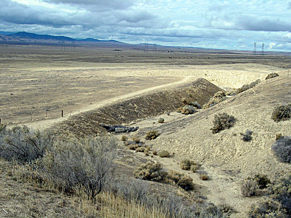
The Carrizo Plain (now a National Monument) is located west of the small town of McKittrick along the southwestern edge of the San Joaquin Valley of California. The straight segment of the stream at center of this west-facing photograph follows the trace of the San Andreas Fault. The fault angles across this photograph from the lower left foreground to upper right. This stream, named after USGS geologist Bob Wallace, has been offset by movement along the San Andreas Fault. It is located in the Carrizo Plain and is of perhaps the most famous feature on the San Andreas Fault. As the stream continues to progressively erode into its channel, right-lateral motion along the San Andreas Fault has moved the downstream portion of the channel northward (block on western, opposite side of the fault is moving to right).
Sediments cut by Wallace Creek were radiocarbon dated at about 3800 years old; the stream channel has been offset about 420 feet since then. Combined with information derived from modern earthquakes, offset along the fault shows a relative rate of motion in the in the Carrizo Plain is in the range of about 1.3 inches (34 mm) per year. Fault scarps and area uplifts show that there is a vertical component of the fault motion. Estimates range in 10 to 20 feet of horizontal slip for every foot of vertical motion. Earthquake fault investigations in the Carrizo Plain show that as many as 130 streams in the park area display evidence of right-lateral slip. USGS geologist Bob Wallace suggested in 1968 that 40 of these channels display offset from the 1857 earthquake ranging from 20 to 50 feet, thus illustrating the variability of earthquake slip behavior. USGS photograph by Phil Stoffer.
Files available for downloading:
View the revision list as an unformatted, text-only file: of99-14revs1a.txt (2 kb).
View the database explanation pamphlet as an unformatted, text-only file: of99-14_2a.txt (22 kb).
View the database explanation pamphlet as a formatted PDF file: of99-14_2c.pdf (36 kB)
DATA
Digital databases are available for GIS users in ARC/INFO Export format. Those who download digital data should also download the descriptive
pamphlet. The ARC/INFO Export files have been compressed with gzip. File sizes (in parentheses) are for the gzip-compressed download file. To download the geologic map data, select one or more of the following:
Geology of99-14_3a.e00.gz (2.5 MB download, 8.1 MB uncompressed).
Structure of99-14_3b.e00.gz (616 kb download, 2.8 MB uncompressed).
Oil Fields of99-14_3c.e00.gz (47 kb download, 168 kb uncompressed).
Topographic Base Map of99-14_3d.e00.gz (19.9 MB download, 63 MB uncompressed).
Sources of Geologic Mapping of99-14_3e.e00.gz (25 kb download, 120 kb uncompressed).
Generalized Columnar Sections of99-14_3f.e00.gz (128 kb download, 520 kb uncompressed).
Correlation of Map Units of99-14_3g.e00.gz (58 kb download, 344 kb uncompressed).
All seven coverages listed above of99-14_3h.tar.gz (23 MB download, 75.3 MB uncompressed).
To download the import routine (written in AML) to import the ARC/INFO export files, download the following (Note: this aml is included with the tar file containing all seven coverages):
Import AML
PLOTFILES
Plotfiles are available for those who wish to produce paper copies of maps prepared from the digital data. These maps have been edited to conform as much as possible to standard U.S. Geological Survey format for geologic maps. The plotfiles are in PostScript format. Note that these plotfiles are formatted to plot on 34 by 34 inch or larger sheets (the geologic map is 35 by 58 inches in size), so a large format color plotter is required to produce a paper map. Alternatively, some software can import PostScript files, allowing the user to manipulate the map image as desired. Those who download plotfiles should also download the descriptive pamphlet.
To download a plotfile in PostScript format (compressed with gzip), select one of the following:
Carrizo Plain geologic map of99-14_4a.ps.gz (15.1 MB download, 54 MB uncompressed).
Carrizo Plain explanation sheet of99-14_4b.ps.gz (1.4 MB download, 6 MB uncompressed).
To download a plotfile in PDF format, select one of the following (Note: Due the 40 inch size limitation imposed by Adobe Acrobat Distiller, the map graphic for the PDF has been cut into two parts, a northwestern section and a southeastern section, with a considerable area of overlap):
Carrizo Plain geologic map - northwestern section of99-14_4a_a.pdf (8.9 MB).
Carrizo Plain geologic map - southeastern section of99-14_4a_b.pdf (7.7 MB).
Carrizo Plain explanation sheet of99-14_4b.pdf (920 kb).
For questions about the scientific content of this report, contact Phil Stoffer
Download a free copy of Adobe Reader.
USGS Information Services
Box 25286 Federal Center
Denver, CO 80225
Telephone: 1-888-ASK-USGS
E-mail: infoservices@usgs.gov
| Help
| PDF help |
| Publications main page
| Western Open-File Reports for 1999 |
| Department of the Interior
| U.S. Geological Survey |
| Geologic Division
| Western Earth Surface Processes Team |
| Privacy Statement
| Disclaimer
| Accessibility |
The URL for this page is:
https://pubs.usgs.gov/of/1999/of99-014
Please send comments and suggestions, or report problems, to:
Michael Diggles
Updated: July 3, 2007 (bwr)
October 28, 2010
(mfd)