
By Dwight C. Bradley1, Timothy M. Kusky1, Peter J. Haeussler1, Susan M. Karl1, and D. Thomas Donley1
U.S. Geological Survey Open-File Report 99-18
1999
U.S. DEPARTMENT OF THE INTERIOR
BRUCE BABBITT, Secretary
U.S. GEOLOGICAL SURVEY
Charles G. Groat, Director
This report is preliminary and has not been reviewed for conformity with U.S. Geological Survey editorial standards or with the North American Stratigraphic Code. Any use of trade, firm, or product names is for descriptive purposes only and does not imply endorsement by the U.S. Government.
1U.S. Geological Survey, Anchorage, Alaska
This is a 1:250,000-scale geologic map of the Seldovia quadrangle in south-central Alaska. It was produced in ARC/INFO and the coverages are included in this Web publication. We have also provided an Adobe Acrobat PDF file of the compiled map.

The map is provided as PDF file that is of a large enough size (49" x 36") that you need to use Adobe Reader (free via the Acrobat button above). View the map as a PDF file (of99-18.pdf; 1.6 MB).
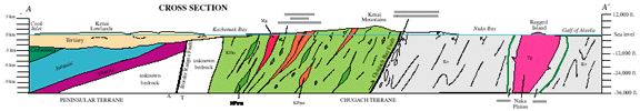
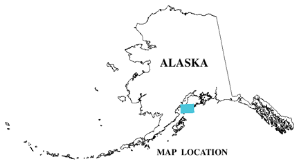
This is a 1:250,000-scale map of the bedrock geology of the Seldovia quadrangle, south-central Alaska. The map area covers the southwestern end of the Kenai Peninsula, including the Kenai Lowlands and Kenai Mountains, on either side of Kachemak Bay. The waters of Cook Inlet cover roughly half of the map area, and a part of the Alaska Peninsula near Iliamna Volcano lies in the extreme northwest corner of the map. The bedrock geology is based on new reconnaissance field work by the U.S. Geological Survey during parts of the 1988-1993 field seasons, and on previous mapping from a number of sources. The new mapping focused on the previously little-known Chugach accretionary complex in the Kenai Mountains. Important new findings include the recognition of mappable subdivisions of the McHugh Complex (a subduction melange of mostly Mesozoic protoliths), more accurate placement of the thrust contact between the McHugh Complex and Valdez Group (Upper Cretaceous trench turbidites), and the recognition of several new near-trench plutons of early Tertiary age.
This is a Web publication of a map product. ARC/INFO files are available below. The metadata files are provided via links in ASCII and HTML versions. The map is provided as PDF file via the link above.
Use the links below to view the metadata for this publication in any of three formats:
svgeol_meta.txt - Plain text file version
svgeol_meta.htm - Straight metadata in an html format; good for Web viewing
svgeol_meta_faq.htm - The important parts of the metadata in an FAQ look; in html
ARC/INFO export files in the data.zip file:
chart.e00 (56 KB)
source.e00 (1.1 MB)
svanno.e00 (352 KB)
svfold.e00 (8 KB)
svgeol.e00 (6.1 MB)
svisogrd.e00 (32 KB)
svquad.e00 (640 KB)
svsandd.e00 (320 KB)
svtopo.e00 (18.7 MB)
svwells.e00 (16 KB)
To contact the senior author, email Dwight Bradley (dbradley@usgs.gov).
The URL of this page is https://pubs.usgs.gov/of/1999/of99-018/
Date created: April 30, 1999
Last modified: October 6, 2006