Open-File Report 99-028
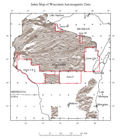
IntroductionThis report contains aeromagnetic data for five areas in northern Wisconsin collected by the U.S. Geological Survey by means of a contract airborne survey, carried out between October 1997 and March 1998. Flights of the aeromagnetic survey were oriented in a north-south direction, at a spacing of 0.5-mile (805 meters), and draped to topography at 1,000 feet (305 meters) above ground. The five blocks of the survey required a total of about 21,000 line-miles of flying. The aeromagnetic data include (1) point measurements taken at 1-second intervals, giving 15 fields of data in ASCII format, including flightline number, latitude, longitude, diurnally corrected magnetic intensity, residual (IGRF-removed) magnetic intensity, time, and altitude, (2) grids of residual magnetic intensity using a Transverse Mercator projection and given in several file formats, and (3) images of the aeromagnetic data and an index map, each given in four graphics formats. Directory Organization
|
Posted online October 15, 2009 Part or all of this report is presented in Portable Document Format (PDF); the latest version of Adobe Reader or similar software is required to view it. Download the latest version of Adobe Reader, free of charge. |
Daniels, D.L., Nicholson, S.W., and Cannon, W.F., 1999, Aeromagnetic surveying in Wisconsin 1997-98 -- Digital data files: U.S. Geological Survey Open-File Report 99-028, available online only.

![]() U.S. Department of the Interior |
U.S. Geological Survey
U.S. Department of the Interior |
U.S. Geological Survey
URL: http://pubsdata.usgs.gov/pubs/of/1999/of99-028/index.html
Page Contact Information: USGS Publications Team
Page Last Modified: Wednesday, 07-Dec-2016 17:50:03 EST
