
This report is preliminary and has not been reviewed for conformity with U.S. Geological Survey (USGS) editorial standards or with the North American Stratigraphic Code. Any use of trade, firm, or product names is for descriptive purposes only and does not imply endorsement by the U.S. Government.
1U.S. Geological Survey, 4200 University Drive, Anchorage, AK 99508-4667
ISBN 0-607-92654-6
This publication consists of the online version of a CD-ROM publication, U.S. Geological Survey Open-File Report 99-136. The data for this publication total 276 MB on the CD-ROM. This online version does not include the Acrobat Search index files or the Adobe Acrobat Reader installer. The installer is available using the link provided below. The CD-ROM may be purchased for $32 by calling 1-(888) ASK-USGS.
The topic of this CD-ROM is the geologic framework of gold-silver vein deposits on Unga Island, in the Shumagin Islands, southwestern Alaska. The core of the publication is a new geologic map at a scale of 1:63,360 and aeromagnetic and electromagnetic survey data acquired by industry over the area of mineralization. Both the geologic map as well as a preliminary interpretation of the geophysical data--which are included by permission of the owner--are aimed towards deciphering the relations among volcanism, tectonism, and mineralization.
Data and discussions are organized in seven chapters, titles of which are outlined in the table of contents. The chapters consist of viewable text and figure images; postscript versions of the frontispiece figures and all chapter figures are included on the CD-ROM as well. The geologic map is a large viewable figure (Plate 1) that accompanies chapter 2. The map was constructed in ARC and its component coverages are provided in the folder "Geology" for users who may wish to modify the geologic data or add their own data.
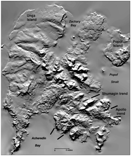
Hillshaded image of Unga Island and, at the upper right, northwestern Popof Island. The image is a computer rendering of the land surface as it would appear if illuminated by a sun at 45 degrees above the horizon, shining from the northwest (upper left). Northwestern Unga Island is underlain by the homoclinally NW-dipping, Miocene Unga Formation (smooth topography). Northeastern Unga Island and northwestern Popof Island are underlain by flat-lying andesitic lava flows of the Oligocene Popof volcanic rocks. The prominent hill near the center of Unga Island is a Miocene dome encircled by carapace breccia and tuff; the encircling escarpment is artificially enhanced by the imaging process. The subcircular area of rugged topography, which extends from the center of Unga Island to the east shore, is underlain by high-silica andesitic lava flows and intrusive sills and domes. Low terrain in southeastern Unga Island is underlain by lava flows and tuff of the Popof volcanic rocks, while most of the prominent peaks are shallow intrusive domes. Southeastern Unga Island is also cut by east- to northeast-trending topographic lineaments. Two of these--the Apollo and Shumagin trends--extend across the full width of the island and have localized gold and silver mineralization. These two important trends are marked by lines at their ends; the Apollo trend bifurcates near the eastern coast of Unga Island. Other northeast-trending lineaments can be seen between the Shumagin lineament and the high peaks at the center of the island. (Image created from a digital elevation model that was constructed for this study and subsampled in 30-m horizontal cells.)
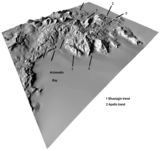
Perspective view toward the northeast, of the hillshaded surface of southern Unga Island. The Apollo lineament is labelled "1" and the Shumagin lineament "2". Other lineaments are marked but not named.
1. Geologic mapping at 1:63,360 scale confirms that Unga and Popof Islands were sites of recurring and intensive magmatism during mid-Tertiary time and provides new details about relations among magmatism, tectonism, and mineralization. Nonindurated marine sediments on the continental shelf were deformed and buried by andesitic lava flows or were interbedded with andesitic and dacitic ash-flow tuffs. Initially effusive volcanism (31-38 Ma) was joined by hypabyssal activity (31-34 Ma) as domes of basaltic andesite to rhyolitic composition were extruded from numerous vents. Ash-flow tuffs occur, but they are of small volume and probably originated at domes. There is no explicit evidence for a caldera structure.
2. Gold and silver mineralization is concentrated in two major, northeast-trending zones of faulting, brecciation, and quartz veining that extend across southeastern Unga Island. Total offset is minor, indicating only incipient faulting although multiple vein sets imply repeated movements. A K-Ar age of vein adularia (34 m.y.) and another of sericitic vein alteration (32 m.y.) show that veining was at least partly contemporaneous with magmatism.
3. Other physiographic lineaments having northeast trends also occur on southeastern Unga Island, which are also sites of silicification and alteration. The lineaments have been the focus of exploratory activity by industry. The multitude of northeast-trending lineaments is suggestive of northwest-directed extension. Northwest-trending lineaments cross-cut the northeast-trending lineaments; the younger lineaments are not as well developed and those that have demonstrable offsets appear to have been subjected mainly to strike-slip movements.
4. The reduced-to-the-pole magnetic field over southeastern Unga Island reflects mainly different rock types, such as lava flows, volcaniclastic rocks, or domes. Broad areas of anomalously conductive bedrock appear to reflect alteration of the volcanic rocks, which at least locally was probably selective of permeable volcaniclastic rocks. Discrete bedrock conductors define linear trends, most of which are northeasterly and coincide or are parallel with physiographic lineaments and mapped faults. Such linear conductive anomalies may be the result of fault-controlled sulfide mineralization. One such linear anomaly ends at the mapped contact with a hypabyssal dome, supporting the inference that faulting and veining were contemporaneous with magmatism.
5. Gold and silver abundances in stream-sediment and heavy-mineral-concentrate samples reflect one but not both of the major mineralized trends. Anomalous concentrations of Au, Ag, As, Mo, and Pb, however, occur in volcanic rock samples from throughout Unga and northwestern Popof Islands.
6. Vein mineralogy, geologic setting, and grade-tonnage data from the main mineralized trends were used to infer the likely deposit type. Types that were considered are Sado, Comstock, and Creede epithermal vein, polymetallic vein, and no existing model. Neither the Comstock nor the Sado types can be rejected, so the "no existing model" option is unnecessary. The Sado model seems the most appropriate.
7. The precise nature of faulting that controlled mineralization is uncertain: Slickenlines indicate both strike-slip and normal faulting on the northeast-trending lineaments. Marine-seismic data, however, document northeast-trending growth faults on the continental shelf near Unga Island that are interpreted to have formed during early to mid-Tertiary time in response to northwest extension (Bruns and others, 1987). Possibly the Unga Island lineaments initially formed in response to extension and were later reactivated by strike-slip movements. In any case, minor but repeated movements on the lineaments would have provided recurring pathways for circulating geothermal waters above and adjacent to active hypabyssal domes.
This report contains directories for each of the seven chapters. In addition to text, we have included digital data files for some of the chapters. The chapter directories and their contents are as follows:
C1 Introduction: Chapter 1, Introduction, by James R. Riehle
C2 Geology: Chapter 2, Geology of Unga Island and the northwestern part of Popof Island, by James R. Riehle, Frederic H. Wilson, Nora Shew, and Willis H. White, the geologic setting and history; includes map as Plate 1; the detailed descriptions of map units and the table of K-Ar ages are included in one file,
C3 Chemistry: Chapter 3, Chemical Compositions of the Volcanic Rocks on Unga Island and Some Inferences About Their Origins, by James R. Riehle, includes a lengthy table
C4 Structure: Chapter 4, Geologic Structures of Unga Island, their Relations to Mineralization, and some Speculations on their Origins, by James R. Riehle
C5 Geophysics: Chapter 5, Geologic Interpretation of DIGHEMIV Airborne Aeromagnetic and Electromagnetic Data over Unga Island, Alaska, by John W. Cady and Bruce D. Smith, including 9 figures some of which are nearly 50 MB
C6 Geochemistry: Chapter 6, Rock, Stream Sediment, and Heavy-Mineral Concentrate Geochemical Data from Unga and Western Popof Islands, Alaska Peninsula, Alaska, by Frederic H. Wilson, Stanley E. Church, and Elizabeth A. Bailey
C7 Deposit types: Chapter 7, Classifying the Shumagin and Alaska Apollo Deposits, by Donald A. Singer

The report is provided as a series of PDF files for which you will need Adobe Acrobat Reader to view. You can download a copy of the latest version (4.0 at the time of this publication) by clicking the button above.
View the opening PDF file (of99-136.pdf; 138 K for intro file; linked files are larger).
For comments about the content of this report, email Ric Wilson
The URL of this page is https://pubs.usgs.gov/of/1999/of99-136/
Date created: June 12, 1999
Last modified: March 1, 2007