
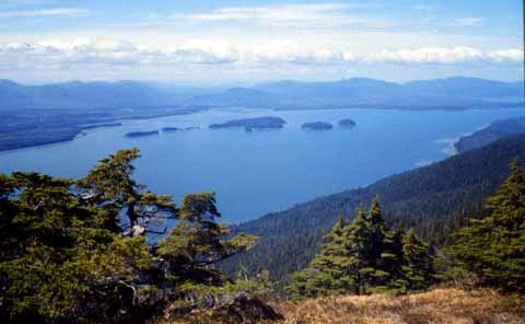
View looking northwest up Duncan Canal towards Kupreanof Mountain. Rocks on west (left) side of the Canal are a combination of deep-sea sedimentary and volcanic rocks of the Permian and Mississippian Cannery Formation. On the east side, the Canal is bordered by Triassic Hyd Group volcanic rocks.
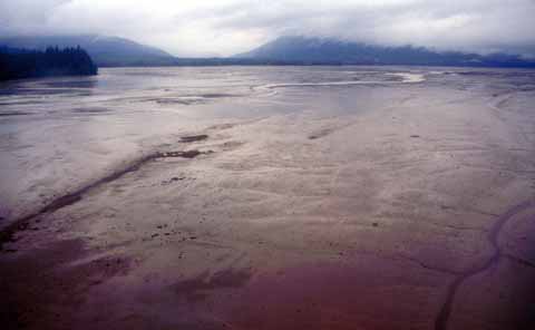
Extensive mudflats are exposed along the reach of Duncan Canal at low tides.
The geologic map of the Duncan Canal-Zarembo Island area is the result of a multidisciplinary investigation of an area where an airborne geophysical survey was flown in the spring of 1997. The area was chosen for the geophysical survey because of its high mineral potential, a conclusion of the Petersburg Mineral Resource Assessment Project, conducted by the U.S. Geological Survey from 1978 to 1982. The City of Wrangell, in southeastern Alaska, the Bureau of Land Management, and the State of Alaska provided funding for the airborne geophysical survey. The geophysical data from the airborne survey were released in September 1997. The U.S. Geological Survey conducted field investigations in the spring and fall of 1998 to identify and understand the sources of the geophysical anomalies from the airborne survey.
This geologic map updates the geologic maps of the same area published in 1997 by David A. Brew and Richard Koch at a scale of 1:63,360. This update is based on three weeks of fieldwork, new fossil collections, and the geophysical maps released by the State of Alaska. Geologic data from outcrops, fossil ages, radiometric ages, and geochemical signatures were used to identify lithostratigraphic units. Where exposure is poor, geophysical characteristics were used to help control the boundaries of these units. No unit boundaries were drawn based on geophysics alone. The 7200 Hertz resistivity maps were particularly helpful for controlling unit boundaries, because different stratigraphic units have distinctive characteristic conductive signatures. Increased knowledge of unit ages, unit structure, and unit distribution, led to improved understanding of the nature of unit contacts.
Northwest- to southwest-directed thrust faults, particularly on Kupreanof Island, are new discovery. Truncated faults and map patterns suggest there were at least two generations of thrusting, and that the thrust faults have been folded. Subsequent right-lateral strike-slip NW-SE faults have offset thrust faults and these in turn are offset by N-S right-lateral strike-slip faults. Our fieldwork raised as many questions as it answered, and we see this map as a progress report at a reconnaissance level. The main contributions of this map are 1) the greater distribution of Triassic rocks, 2) increased fossil age information, and 3) the identification of thrust faults within and between units.
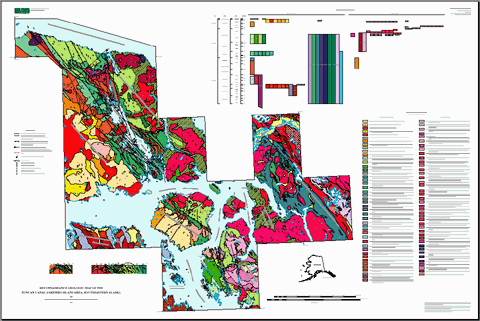
Reduced image of the Duncan Canal-Zarembo Island area geologic map.
Files available for downloading:
Download Version history file for this report
HTML VERSION OF PAMPHLET
View the pamphlet of text, references, descriptions of map units, and photographs at a screen resolution of 72 dpi of many of the rock units (of99-168-pamphlet.html (116 kb with links to 65 JPG photograph files).
PDF VERSION OF MAP AND PAMPHLET
Download any of the 67 files included in this report from the PDF folder (59 MB).
View the pamphlet containing text, references, descriptions of map units, fossil-data table, and links to photographs of outcrops and fossil-locality points on the map. Pamphlet is 30 pages long with links to other PDFs (264 kb).
View a single sheet PDF version of the map (1.3 MB).
Notes: The report is provided as PDF files for which you will need Adobe Acrobat Reader to view. The pamphlet can be printed on standard 8½" x 11" printers. The map can be printed on plotters that use paper at least three feet wide (for example, HP 2500). The map is 36" wide and 30" long.
The pamphlet PDF contains links to photograph PDFs of outcrops for many of the units described; a total of 65 photographs are available. The table of fossil data at the end of the pamphlet contains links to zoomed-in views of the 57 sample-collection points on the map. Links are shown as blue boxes around the text. In some cases, additional photographs of the same unit are provided. These are shown as blue notes in the margin. When you print the pamphlet, the blue links will not show. The photograph PDFs will fill your screen and, when printed, will be 5.12 inches in the long dimension. The resolution of the photographs varies, but is commonly 600 dpi for high-quality prints.
The pamphlet contains over 100 links that move you to other PDF files. When you view it online using the Acrobat Plug-In for your Web browser, the "Back" button puts you back on page 1 instead of the page where you left off. If you load the entire collection of 67 PDF files onto your hard disk, however, you can jump back and forth between the text and the link targets with ease. If your copy of Acrobat Reader has "File" "Preferences" "General..." "Open Cross-Document Links In Same Window" selected, you should deselect it. This will keep the main document open while you open and close the linked PDF files.
Sometimes clicking on a hyperlink such as those below will display, or attempt to display, the file on the screen rather than downloading it. To force a download instead, do the following:
MACINTOSH: hold the mouse button down for a moment to display a pop-up menu and select "Save this link as..." (Netscape Navigator) or "Download
Link to Disk" (Internet Explorer) and navigate to where you want the file saved.
WINDOWS: use the right mouse button to display a pop-up menu and select "Save Link As..." (Netscape Navigator) or "Save Target As..." (Internet Explorer) and navigate to where you want the file saved.
POSTSCRIPT FILES
Download a PostScript version of the map of99-168.ps from the postscript folder (10.6 MB).
DIGITAL DATASET
Download the digital dataset for of99-168 from the GIS folder (10.6 MB).
Download the FGDC-compliant metadata for this dataset (40 kb).
For questions about the scientific content of this report, contact Sue Karl
Download a free copy of Adobe Reader
USGS Information Services
Box 25286 Federal Center
Denver, CO 80225
Telephone: 1-888-ASK-USGS
E-mail: infoservices@usgs.gov
| Help
| PDF help |
| Publications main page
| Open-file reports [on line] |
| Department of the Interior
| U.S. Geological Survey |
| Geologic Division
| Alaska Science Center |
| Privacy Statement
| Disclaimer
| Accessibility |
The URL for this page is:
https://pubs.usgs.gov/of/1999/of99-168/
Please send comments and suggestions, or report problems, to:
Michael Diggles
Created: October 27, 1999 (cad)
Updated: June 12, 2008 (bwr, mfd)
![]()