
1Menlo Park, California 94025
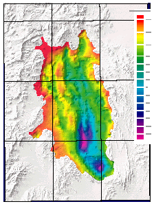
Yucca Flat is a Tertiary extensional basin located in the northeast corner of the Nevada Test Site, Nye County, Nevada. The basin formed as a result of eastward extension and is dominated by north-south trending, east-dipping normal faults. This image is of the gravity map of the basin.
Yucca Flat is a Tertiary extensional basin located in the northeast corner of the Nevada Test Site, Nye County, Nevada. The basin formed as a result of eastward extension and is dominated by north-south trending normal faults. The major faults in the basin dip eastward.
The basement itself is composed primarily of late Proterozoic to Pennsylvanian sedimentary rocks that have a complex tectonic history of Mesozoic compression and extension prior to Tertiary extension. The northernmost tip of Yucca Flat contains Mesozoic intrusive bodies, the Gold Meadows stock just to the northwest of the basin, and the Climax stock, at the north end. The basin fill is composed of mid to late Miocene volcanic deposits and Quaternary sediment.
The basin-basement contact for Yucca Flat was modeled using isostatic gravity data, a linear density-depth function for the basin deposits, and drill-hole constraints to produce a digital database of both the depth to basement and the gravitational anomaly associated with the basement rocks. The model predicts a depth of roughly 2,500 m in the deepest, southern part of the basin. The model shows offsets in the basement rocks along both the Carpetbag and Yucca faults. The basement rocks of Yucca Flat have a higher gravity anomaly west of the N-S trending Carpetbag fault, suggesting higher density rocks on the west side of the valley.
Files available for downloading:
Download the written document portion of of99-310.pdf as a PDF file (5.8 MB).
Download the depth-to-basement data file depth200.asc.txt as an ASCII flat file (514 kb).
Download the deleted gravity stations data file del_data.asc.txt as an ASCII flat file (8 kb).
Download the study boundary data file boundary.asc.txt as an ASCII flat file (8 kb).
Notes:
Sometimes clicking on a hyperlink will attempt to display the file on the screen rather than downloading it. To force a download instead, do the following:
Macintosh: hold the mouse button down for a moment to display a pop-up menu and select "Save this link as..." (Netscape Navigator) or "Download Link to Disk" (Internet Explorer) and navigate to where you want the file saved.
Windows machines: use the right mouse button to display a pop-up menu and select "Save Link As..." (Netscape Navigator) or "Save Target As..." (Internet Explorer) and navigate to where you want the file saved.
For questions about the scientific content of this report, please contact: Geoffery Phelps
Download a free copy of Adobe Reader
USGS Information Services
Box 25286 Federal Center
Denver, CO 80225
Telephone: 1-888-ASK-USGS
E-mail: infoservices@usgs.gov
| Help
| PDF help |
| Publications main page
| Western Open-File Reports for 1999 |
| Department of the Interior
| U.S. Geological Survey |
| Geologic Division
| Western Earth Surface Processes Team |
| Privacy Statement
| Disclaimer
| Accessibility |
The URL for this page is:
https://pubs.usgs.gov/of/1999/of99-310/
Please send comments and suggestions, or report problems, to:
Michael Diggles
Updated: October 23, 2009 (bwr; mfd)