Kentucky Geological Survey
Room 228 Mining and Minerals Resources Building
Lexington, KY 40506
Telephone: (606) 257-5500
Fax: (606) 257-1147
e-mail: wanderson@kgs.mm.uky.edu
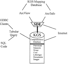
Figure 1. Organizational Structure and access points for the KGS Comprehensive and GIS Mapping Databases. |
The Kentucky Geological Survey's primary geologic mapping database will be connected to the KGS comprehensive geologic/hydrologic relational database. This comprehensive database (Fig. 1) has evolved considerably during the 20 years KGS has been computerizing data. Currently it contains data from more than 200,000 geographic locations throughout the Commonwealth. These data consist of well locations (petroleum and water), well construction information, coal-thickness measurements, sample descriptions, analyses (coal, water, petroleum), and descriptive information. Plans for the near future are to install a spatial data engine (SDE) that will provide the capability to store spatial information in the relational database. In addition, plans are to link images derived from scanning official paper documents (for example, plats, drillers logs, well tickets, down-hole logs) to their respective computerized records in the database. This will provide users with immediate access to copies of the original records as received by KGS.
Retrieving and manipulating data from the main relational database is accomplished by client applications using ODBC (open data base connectivity) drivers, SQL (structured query language) code, or programming languages such as Visual Basic (VB) or C++.
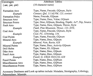
Geologic map information is collected as vector data by a GIS and stored in the KGS digital geologic mapping database. These spatial data consists of numerous coverages such as formations, structures, faults, coals, minerals, fossils, drill holes, and dikes. Each coverage or layer consists of polygons, arcs, or points, and has attribute tables that describe the coverage. The formation code (FMCODE) and geologic quadrangle map name (GQNUM) are primary attribute headings and serve to link other descriptive tables such as type, name, and style. These attribute tables are the basic components of the mapping database, and are directly related by scripts or hot links to additional digital mapping subdatabases containing information on subjects such as metadata, lithology, stratigraphy, mineral veins, and fossils (Fig. 2).
|
Figure 2. Components of Kentucky Geological Survey Spatial Database for Geologic Map Information. |
The Stratigraphic table and code of the spatial database is very important in that it is a primary table that will link the data captured in the KGS spatial mapping database with the U.S.Geological Survey (USGS) draft data model (Fig. 3).
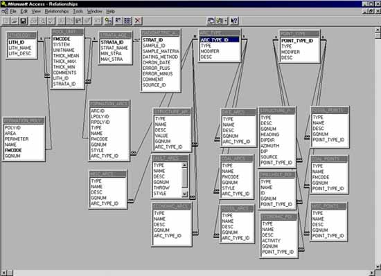
Figure 3. The relationships between the KGS Digital Geologic Mapping Database Structure (formation, structure, faults, dikes and coal arcs and polygons) and three primary components of the USGS draft data model (lithology, rock unit, and strata age). These three tables serve as the primary link to access auxillary tables in the KGS spatial and relational databases. |
Other subdatabases are designed to meet various needs; for example, the metadata files use a State-suggested software for metadata compilation. The lithology database is created to supplement the digital mapping files, and the fossil database is linked to a USGS fossil identification number and description.
A GIS can be used to perform spatial queries, to locate oil-or water- well information and coal-bed thickness or mineral data; and these data are linked to other geologic, engineering, and mineral databases for resource manipulations, searches and modeling. Pseudo 3-dimensional models have been created using digital elevation models and 2-dimensional digital geologic maps to give the appearance of a three-dimensional view. This allows planners, developers, miners, and engineers to conduct slope stability studies, approximate cut and fill calculations, and use the GIS analytical tools to manipulate geologic data. Digital elevation models and geologic data have been manipulated to obtain line-of-sight surface profiles and area measurements. Plans for adding z-values will enable volume measurements to be performed.
Currently, the KGS can integrate its spatial mapping data files with the Kentucky Department of Transportation's (DOT) engineering database so that rockfall and landslide parameters can be merged into our digital geologic mapping files. DOT is currently evaluating these data to determine how they can be used to increase the efficiency of highway planning and maintenance. These geologic map files have also been used as a base to integrate other nongeologic coverages such as environmental wetlands, parcel mapping, cultural, and best cost estimates for planning highway corridors.
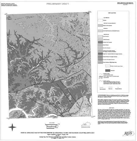
Customized scripts have been created to develop a template for automatic formatting of hard-copy output of digital map data. These scripts will enable a user to specify the name of the quadrangle, author, and date; modify a generic legend and stratigraphic information so that a draft quality quadrangle map can be plotted (Fig. 4). This draft map does not have a geologic column or cross section, but we are working on methods to create these two components.
|
Figure 4. Preliminary draft of a geologic map using an Avenue script to create a template for rapid plotting of different geologic maps. |
|
Return to Table of Contents
This site is https://pubs.usgs.gov/openfile/of99-386/anderson1.html
|