U.S. Geological Survey
National Mapping Division
Mid-Continent Mapping Center
1400 Independence Road
Rolla, Missouri 65401
Telephone: (573) 308-3736
Fax: (573) 308-3652
e-mail: rlemen@usgs.gov
As the U.S. Geological Survey's (USGS) National Mapping Division (NMD) is challenged to do more with less and at the same time increase its response to customer concerns, the traditional methods of revising the present primary series of topographic maps are no longer feasible. (Primary series maps include 1:20,000-scale quadrangles of Puerto Rico, 1:24,000- or 1:25,000-scale quadrangles of the conterminous United States and Hawaii, and 1:63,360-scale quadrangles of Alaska.) The NMD is responding by continually experimenting and devising new methods by which graphic revision can be accomplished. This proposed approach will provide the means to determine and use the most cost-efficient method(s) for graphic revision. By devising such a revision methodology, that encompasses the concerns expressed in this paper and responding to the needs of our graphic customers, the NMD will become more responsive to the graphic segment of the consumer base and in turn minimize the cost of production.
Although the USGS-NMD has historically been known for the large-scale topographic maps produced through its Graphic Revision Program, it has, along with the rest of the mapping industry, made the transition to computer-aided mapping. (Information on NMD's Graphic Revision Program can be found on the Internet at http://mapping.usgs.gov/mac/isb/pubs/factsheets/fs01698.html.) During the late 1970's and early 1980's, NMD's Vector Program was created. This program initially focused on the production of digital vector data that used the graphic map as a source. The data collected represented the various feature categories shown on the map. These categories included transportation, hydrography, hypsography, and boundaries, among others. The growth and development of these digital data, defined as digital line graphs (DLG), along with the 1990 Census Program, became the foundation for the geographic information system (GIS) industry and the focus of our future. Our Vector Program contributed significantly to the development of concepts that led to the 1994 signing of Presidential Executive Order (EO) #12906 establishing the National Spatial Data Infrastructure (NSDI) and to the introduction of the framework concept. (Information on NMD's Vector Program is available on the Internet at http://mapping.usgs.gov/dpi/vector8.html.) Although this EO was a consolidated effort between multiple Federal agencies, the foundation for it was based on the work previously done by the NMD.
Throughout the evolution of the Vector Program, the graphic customer was viewed as making the digital transition along with the rest of the industry. It was assumed that since graphics were the source for the Vector Program, graphics could easily be derived from this digital product. Digital revision would support the graphic revision requirement since the vectors would reflect change and, in turn, serve as sources for the new graphics. As this concept matured, graphics became more and more dependent upon the existence of digital vectors, to the extent that both the Vector and Graphic Revision Programs were entirely dependent upon the existence and collection of vector information. The NMD still retained an analog graphic process for small-scale and special products, but our primary series became dependent upon the vector source. This dependency has become the underlying focus of many of our present digital production policies and standards. (NMP Geospatial Standards are available on the Internet at http://mapping.usgs.gov/standards/.)
In an effort to reduce the expense of both digital and graphic products and to increase their availability, the NMD looked at the product content. In an effort to improve production efficiencies, the NMD reviewed and modified standards for the Vector Program that affected the content of the conventional USGS graphic products. (It should be noted that many content changes also came about because the NMD no longer had the resources to perform field verification.) The public expressed concerns that these vector policies would have negative impacts on the quality and availability of future USGS topographic maps. Many customers have encouraged us to revisit some of these decisions.
Digital production has traditionally been cooperator driven and focused on category-specific collection and revision. This leaves those unrevised or uncollected map categories out-of-date when compared to the newer vector data. This becomes a significant problem when trying to produce a consistent graphic product. The vector-based product generation process uses digital vector data to produce a graphic map. It requires the update of map features to revise the entire quadrangle. Graphic customers have expressed concern that they do not want to be burdened with the additional expense of paying for the production of vectors to produce the graphic product they want. A process that integrates both color separates and existing vector data provides a less expensive revision alternative.
As the GIS industry matures and the State and local governments move their daily activities to GIS-based applications, the NMD is going to be challenged to maintain continuity with regard to the accuracy and content of local GIS holdings. The data sets held and maintained by other agencies in many cases show additional content and are of a newer vintage. To republish a graphic that is out of date compared with local data is embarrassing for the USGS. The Graphic Revision Program needs to maintain consistency with new local data to avoid this problem. This becomes increasingly difficult if policy requires data compatibility between the Vector and Graphic Revision Programs.
The NMD does not have the resources and capacity to meet the demands of the Graphic Revision Program. Therefore, to ensure the production and availability of revised graphic maps, we must use data sources produced by other organizations. A major component of the NSDI is the development and implementation of a national geospatial data framework. As part of the framework concept, NMD will pursue partnerships with other Government agencies and the private sector to use locally produced data that can contribute to its mapping program. We foresee spatial data produced by public and private sector organizations contributing to the revision of our maps. By implementing integration techniques, we can take advantage of these local up-to-date data holdings.
The NMD recognizes the need to find common ground between digital and graphic customers at a minimal expense and without degrading its products. A key approach to this problem is to separate the product dependencies and focus strictly on the customer's needs. This approach prevents the vector cooperator from being burdened by the expense of supporting a graphic product. At the same time, when applied to the Graphic Revision Program, it provides a significant cost savings to the graphic customer. If the Graphic Revision Program is not burdened by the expense to complete vector data to an achievable vector standard, the overall expense to the graphic customer is significantly less.
A goal of the Graphic Revision Program is to produce standard cartographic products regardless of the data sources. The focus needs to be broad enough in scope that it ranges from graphic revision using a full range of digital sources to a reprint process using existing analog techniques. Vectors should be used if readily available but should not be required. If vectors are collected and revised during the graphic process, they should be provided to the Vector Program as transactional updates. If a customer desires both vectors and graphics, the Vector Program can deliver a geographic source for use in an automated generalization process to generate graphics.
The NMD has developed a raster/vector process that will work with existing vector and raster capabilities. This process allows the revision of the graphic map from existing vector or graphic source data. This approach ensures a diverse graphic revision process that uses both analog and digital sources to update products. Figures 1 and 2 illustrate the vector and raster revision processes.
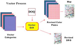
Figure 1. Diagram illustrating graphic map revision through the vector process. |
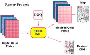
Figure 2. Diagram illustrating graphic map revision through the raster process. |
The RGR process was developed to reduce the production costs and the amount of time it takes to revise quadrangle maps, while still meeting customers' needs for a graphic product. This method starts by scanning the map separates at 1,000 dots per inch (dpi) and then making the appropriate additions and deletions to the map detail on the basis of new data sources. For the most part, the sources used are digital orthophoto quadrangles (DOQ). (Information on DOQ's is available on the Internet at http://nsdi.usgs.gov/products/doq.html.)
There are two categories of map revision; complete revision and basic revision. In the complete revision process, all features are corrected and updated. Content is validated by field checking against ground truth. Contours are revised. The revised map meets all current NMD standards for feature content and National Map Accuracy Standards for positional accuracy.
In the basic revision process, many features are revised by interpreting image sources, such as digital orthophotos or aerial photographs. The features are not verified through field checking, and contours are generally not revised. The revised map maintains the positional accuracy of the previously published map. Most resources are focused on basic revision because this method is less expensive and more maps can be revised in a given period of time.
As part of the NMD's revision program, a new digital raster graphic (DRG) will be produced for every revised graphic. Recently DRG's, scanned raster images of USGS topographic maps, were completed for all of the USGS primary series maps. (The paper 7.5-minute topographic maps were scanned at 250 dpi.) Since they were produced from the existing paper topographic maps, the DRG's are only as current as the map sources. Now with the raster revision process in place, the NMD can produce a new DRG that reflects the revised graphic. (Information about NMD's DRG's is available on the Internet at http://mcmcweb.er.usgs.gov/drg/.)
Although the new DRG's are being produced through a different process, they will adhere to the same standards and specifications that were used during the production of the initial DRG's. Original DRG coverage for the country was produced by scanning the paper topographic map itself. During the raster revision process, each map separate that is scanned and then revised through the raster edit process will be used to produce the DRG. Where we made one scan of the paper map, we will now have a raster scan of each revised color separate. These raster scans will be combined to produce the DRG.
Although this paper describes the transition of NMD's methodology for revising its primary series maps, it should be noted that the NMD does not rely solely on in-house production to accomplish its goals. A significant part of the map production will be accomplished by the private sector through contract work. Within the past year, the NMD has begun contracting some of its revision work. The contractor will steadily increase its share of the revision program over the next few years.
|
Return to Table of Contents
This site is https://pubs.usgs.gov/openfile/of99-386/lemen.html
|