
1 U.S. Geological Survey, 2255 N. Gemini Dr., Flagstaff, AZ 86004
2 University of Toledo, Toledo, OH 43606
3 1133 Jenifer St., Madison, WI 53703
4 Northern Arizona University, Flagstaff, AZ 86011
5 1573 Manzanita Ave., Santa Rosa, CA 95404

Many geothermal areas in Nevada contain hot springs. The waters from Alkali Springs near Goldfield, Nevada, originally rose at a number of small seeps, but in the early 1900's, Combination Mines Co. drove a 40-foot adit into the slope to concentrate the flow into a single channel. The water was pumped to the Combination Mill at Goldfield, located about 10 miles southeast. In 1907, the temperature at the face in the adit was 140°F. A low dome of gray-brown travertine is present 100 yards north of the adit. The springs are reported to contain lithium although adjacent Alkali Flat does not. The Joe Guisti family operated the springs as a spa during Goldfield's heyday when a large building and an indoor wooden swimming pool were on the site. This 1976 photograph shows the weathered, but still standing bathhouse on the spring site.
The Great Basin of the southwestern United States (figure below) was the focus of concerted exploration and leasing activity by the geothermal power industry beginning in the 1970's. Chevron Geothermal and Phillips Petroleum Company together evaluated more than 75 geothermal prospects with a potential for accessible temperatures of 150 ¡C or greater. More than 25 additional sites were assessed by other companies, bringing the total number of potentially high-temperature sites evaluated by industry to more than 100.
Most of the subsurface temperature data from the Chevron/Phillips projects were purchased by CalEnergy Inc. During the summer of 1998, the CalEnergy holdings were inventoried by USGS personnel, and subsurface temperature data from several hundred of those holes were purchased by the U.S. Department of Energy for curation by Idaho National Engineering and Environmental Laboratory (INEEL). As part of that transaction, the USGS agreed to digitize the data and make them available on the World Wide Web.
In this report, we combine the data set acquired from CalEnergy, with miscellaneous data from Geothermal Resources International (GEO), Aminoil USA, AMAX and other companies which were acquired by the USGS from INEEL in 1995, and make them available to any interested user via this web site. All data were obtained using calibrated thermister probes having an accuracy of about 0.1 °C. The data as received were in a variety of formats and units, with most locations listed as Section, Township, and Range. They were primarily copies of field data sheets, but some were in interpretive reports, and others were analogue temperature-depth plots at various scales. Gradient values shown in the database were obtained directly from the field data sheets or plots. These were usually based on a visual straight-line fit of the data from the lowermost section of the hole. After a few random checks of these estimates, we adopted these values for our presentation.
Files available for downloading:
Download or view the Database as a PDF file (116 kb).
Download the Database.xls as a Excel file (144 kb).
Begin by clicking on the image below.
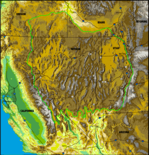
Figure 1. The Great Basin.
Links to Other Online Thermal Data
Suggested citation and version history
For questions about the scientific content of the report, contact John Sass or Colin Williams.Download a free copy of Adobe Reader
This report is available via print on demand.
USGS Information Services
Box 25286 Federal Center
Denver, CO 80225
Telephone: 1-888-ASK-USGS
E-mail: infoservices@usgs.gov
| Help
| PDF help |
| Publications main page
| Open-file reports [on line] |
| Department of the Interior
| U.S. Geological Survey |
| Geologic Division
| Western Mineral Resources
| Western Region Geopubs Home Page |
| Privacy Statement
| Disclaimer
| Accessibility |
The URL for this page is:
https://pubs.usgs.gov/of/1999/of99-425/
Please send comments and suggestions, or report problems, to:
Michael Diggles
Updated: September 25, 2007 (bwr); March 3, 2009 (mfd)