
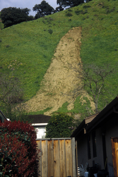
Intense 1998 El Níno rains activated this debris flow type of landslide in eastern Fremont in southern Alameda County. The bedrock is heavily fractured and the shallow soils rich in "shrink and swell" clays with deep cracks. This combination allowed rain water to quickly percolate into the dry soil via the deep cracks and cause the slide.
The ten counties that comprise the greater San Francisco Bay region (SFBR) occupy some 7600 square miles, exclusive of water bodies, much of it in sloping ground. Alameda County lies along the eastern border of the SFBR. Most of the land that is not flat terrain is subject to landslides and other types of slope failure. Landslides are much more common features of the Bay Region landscape than is generally realized. Some 75,000 of them, ranging widely in age, size, and type and degree of activity, have been mapped within just the ten counties. Depending on location, the number of landslides identified averages about ten per square mile and varies from zero to 40. It is often necessary to find out whether a landslide exists at a particular Bay Area locale. Homeowners, landscape architects, real estate developers, city planners, building officials, emergency-response personnel, civil engineers, utilities workers, and others all have occasion to know where the landslides are. Because existing old and ancient landslides may be reactivated by severe winter storms, timely availability of information on landslide location can reduce losses of life and property to the region's expanding population.
County-size landslide maps, although an excellent record of the Bay Region landslide hazard, have their limitations. The near-total coverage of the ten-county area does not mean near-100% identification of the landslides themselves. Most of the maps were prepared by interpretation of aerial photographs rather than by field study. They are preliminary or reconnaissance inventories, not exhaustive records of slope failures. Inclusivity of landslides varies from map to map, depending on date of the airphotos; publication scale of the map; landslide size, type, age or degree of degradation; density of tree cover; and each geologist's experience and mapping philosophy. The maps appended to Table 1 probably underestimate the total number and extent of Bay Region landslides.
This landslide-inventory map should be regarded as a guide to what actually may exist on the ground. Indication of a landslide on a map in a particular locale does not guarantee the presence of an actual landslide. Similarly, the absence of a landslide on a map does not guarantee that a landslide does not exist on the ground. The maps indicate what may be expected, but they do not take the place of an on-site survey or the professional judgment of a licensed engineering geologist or geotechnical engineer.
Files available for downloading:
DATABASE CONTENTS
Note: The following sets of digital files comprising the database are encoded in more than one format. Names of the files are unique designators based on the report identifier, of99-504, followed by part numbers (i.e. 1 through 8 below) and an extension indicating file type. Some files have been bundled using the UNIX Tape Archive or "TAR" utility (.tar extension). All larger files have been compressed with the gzip utility, indicated by the .gz extension.
Download the revisions list of99-504revs_1a.txt. This is an ASCII file of the parts of the report and at what version number of the report each was last revised (if at all) followed by a chronological list that describes any revisions (8 kB).
Download the accompanying pamphlet text of of99-504_2a.txt as an ASCII file (52 kB).
Download the accompanying pamphlet text of of99-504_2b.ps as a Postscript file (552 kB).
Download the accompanying pamphlet text of of99-504_2c.pdf as a PDF document (96 kB).
Download the database for landslide deposits of99-504_3.e00.gz as an ARC export coverage containing both lines and polygons. Import aml will name this coverage al-slid_um (2.7 MB).
Download of99-504_4.e00.gz the database for small landslide deposits as an ARC export coverage for La Costa Valley quadrangle containing points. Import aml will name this coverage lc-smls_um (8 kB).
Download of99-504_5.tar.gz ARCVIEW shape files bundled as one tar file. Note: point files exist only for the La Costa Valley quadrangle (5.2 MB).
Note: This tar file yields when opened:
-line files -- al-arc.dbf, al-arc.shp, and al-arc.shx
-polygon files -- al-poly.dbf, al-poly.shp, and al-poly.shx
-point files -- lc-smls.dbf, lc-smls.shp, and lc-smls.shx
Download the supporting files OF99-504 6.tar for ARC/INFO, bundled as one package. These files appear as utm2sp.prj, sp2utm.prj and import.aml. The first two are projection files to convert between the UTM Zone 10 projection of the database and state plane projection. The third is an ASCII script written in Arc Macro Language for converting the ARC export files into usable coverages and INFO files that are assigned standard names (see Importing the ARC export files) (8 kB).
Download the Quadrangle Index Database. It is composed of data files representing lines and polygons of the quadrangle index (ARC export and ARCVIEW shape format). The ARC version also includes quadrangle names as annotation. The following files are available:
Download of99-504_7a.e00.gz that is the ARC export coverage containing lines, polygons, and annotation. Import.aml will name this coverage al- index_um (32 kB).
Download of99-504_7b.tar.gz that is line and polygon ARCVIEW shape files bundled as one tar file. When opened, the tar file yields:
- line files: grdlns.dbf, grdlns.shp, and grdlns.shx
- polygon files: grdpys.dbf, grdpys.shp, and grdpys.shx (total of 36 kB).
Download the Plot Files for the map Landslide Deposits in Alameda County, which measures 36 by 53 inches when plotted:
Download of99-504_8a.ps.gz as a Postscript file (3 MB download, 12 MB uncompressed).
Download of99-504_8b.pdf as a PFD document (2.9 MB).
Download Opening the Database Files for assistance in opening the above files (4 kb).
For questions about the scientific content of this report, please contact: Richard Pike
Download a free copy of Adobe Reader
USGS Information Services
Box 25286 Federal Center
Denver, CO 80225
Telephone: 1-888-ASK-USGS
E-mail: infoservices@usgs.gov
| Help
| PDF help |
| Publications main page
| Westerm Open-file Reports for 1999 |
| Department of the Interior
| U.S. Geological Survey |
| Geologic Division
| Western Earth Surface Processes Team |
|Western Region GIS Home Page |
| Privacy Statement
| Disclaimer
| Accessibility |

![]()
The URL for this page is:
https://pubs.usgs.gov/of/1999/of99-504/
Please send comments and suggestions, or report problems, to:
Michael Diggles
Created: February 4, 2000
Updated: August 13, 2007 (bwr); December 11, 2008 (mfd)