Surficial Geology and Distribution of Post-Impoundment Sediment of the Western Part of Lake Mead Based on a Sidescan Sonar and High-Resolution Seismic-Reflection Survey
Based on U.S. Geological Survey Open-File Report 99-581
1David C. Twichell, 1VeeAnn A. Cross, 2Mark J. Rudin, and 1Kenneth F. Parolski
1 U.S. Geological Survey, Woods Hole, MA
2 Department Health Physics, University of Nevada at Las Vegas, Las Vegas, Nevada
Abstract
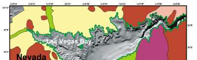
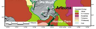
Sidescan sonar imagery and high-resolution seismic-reflection profiles were collected in Las Vegas Bay and Boulder Basin of Lake Mead to determine the surficial geology as well as the distribution and thickness of sediment that has accumulated in these areas of the lake since the completion of Hoover Dam in 1935 (Gould, 1951). Results indicate that the accumulation of post-impoundment sediment is restricted to the original Colorado River bed which runs down the axis of Boulder Basin from Boulder Canyon to Hoover Dam, and the old Las Vegas Creek bed that bisects Las Vegas Bay. The sediment cover along the original Colorado River bed is continuous and is typically greater than 10-m thick throughout much of its length with the thickness in some areas exceeding 35 meters. The flat-lying nature of the deposits suggests that they are the result of turbidity currents that flow the length of the lake. The sediment cover in Las Vegas Bay is much thinner (rarely exceeding 2 m in thickness) and more discontinuous. The source for these sediments presumably is Las Vegas Wash and a series of other ephemeral washes that empty into this part of the lake. The presence of sediments along the entire length of the Las Vegas Creek bed suggests that turbidity currents probably are active here as well, and that sediment has been transported from these streams at least 10 km down the axis of this valley to where it enters Boulder Basin. Alluvial deposits and rock outcrops are still exposed on large parts of the lake floor.
|
Acknowledgements
We acknowledge the assistance of the staff of the Callville Bay Marina for their help in the mobilization of one of their vessels for this survey. Assistance by the National Park Service in Boulder City, Nevada, also facilitated field operations. David Foster's suggestions on seismic processing procedures and assistance in loading the seismic data into Seisworks is greatly appreciated. Reviews by David Foster and Kathryn Scanlon of the U. S. Geological Survey improved this manuscript. The Southern Nevada Water Authority provided funding for this field program.
|