Surficial Geology and Distribution of Post-Impoundment Sediment of the Western Part of Lake Mead Based on a Sidescan Sonar and High-Resolution Seismic-Reflection Survey
Results
Pre-Impoundment Sediment
Click on each figure for larger image with caption.
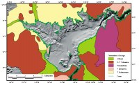
The generalized morphology of the lake and the surrounding area is shown in Figure 1. The lake walls are steep in Boulder Canyon and near Hoover Dam. These steep cliffs coincide with exposures of Precambrian gneiss and Cretaceous and Tertiary volcanic and intrusive rocks (Wilson et al, 1969; Stewart and Carlson, 1978) around the margins of the lake
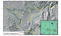
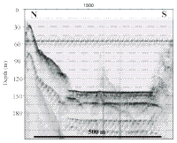
(Fig. 2). In Boulder Basin, the gradient of the lake walls is gentler off areas where alluvial deposits and Tertiary-aged sedimentary strata are present. The axis of the basin is flat, and the gradient between Boulder Canyon and Hoover Dam is remarkably gentle. Water depth, based on the bathymetry collected during this survey, on the easternmost line in the axis of Boulder Canyon was 142 m while, near Hoover Dam, 26 km to the southwest, the lake is 147 m deep. Las Vegas Bay has a narrow, steep-sided valley running down its axis that opens into Boulder Basin northeast of Saddle Mountain Fig. 1.
Several smaller tributaries feed into this axial valley showing a well-defined dendritic drainage pattern that was cut in the Tertiary sedimentary strata prior to formation of the lake. This morphology characterizes the northern flank of the lake with Swallow, Callville, and Hamblin Bays having dendritic drainage networks in their floors as well. This northern section of the lake presumably is underlain by the Tertiary sedimentary strata that is exposed onshore which has the same distinctive morphology Fig. 2).
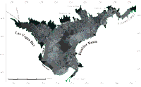
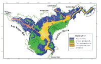
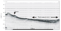
The sidescan sonar image shows four distinctive geologic provinces on the lake floor (Fig. 4 and Fig. 5). Two of these provinces, rock outcrop and alluvial deposits, reflect the pre-impoundment geology of the area while the other two, thin and thick sediment show the distribution of deposits that are interpreted to have accumulated in the lake since its formation.
Areas of rock outcrop show on the sidescan image either as high-backscatter or as alternating bands of high and low backscatter. The high-backscatter signature represents steep
rock walls that face the sonar, while the alternating high- and low-backscatter bands appear to represent terraced outcrops. The terraces probably are controlled by bedding of the underlying strata. The distribution of these two signatures coincides with the distribution of different rock types surrounding the lake. The areas of rock outcrop associated with uniform high backscatter Fig. 8 closely correspond with the distribution of Precambrian gneiss, Cretaceous through Tertiary volcanic and intrusive rocks around the lake Fig. 2). These rocks are resistant to erosion and form the steep cliffs that surround the lake. These cliffs are prevalent east of Hamblin Bay (especially in Boulder Canyon), in the southwestern part of the lake surrounding Promontory Point, and also off of Saddle Mountain.
Areas of alternating bands of high and low backscatter that have an extensive network of valleys cut through them Fig. 9 occur in Las Vegas Bay and along the northern side of Boulder Basin from Las Vegas Bay eastward to Hamblin Bay. North of this part of the lake, the rocks consist of a mix of Tertiary fluvial deposits and tuffs (Stewart and Carlson., 1978) which were extensively eroded by fluvial processes prior to formation of the lake.
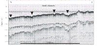
Alluvial deposits are the second pre-impoundment geologic province that is still preserved along large sections of the flanks of the lake (Fig. 4, Fig. 5). These deposits show on the sidescan sonar image as areas of uniform moderate backscatter which are dissected by an intricate network of small channels Fig. 10.
These channels coalesce downslope, and in some cases form larger braided streams Fig. 10. Two large areas of alluvial deposits occur adjacent to alluvial fan deposits that have been mapped on land Fig. 2). These large areas of alluvial deposits occur along the southeastern side of Boulder Basin and off of Boulder Beach (Fig. 5). Smaller areas of alluvial deposits are also found in Las Vegas Bay and Callville Bay.
|