U.S. DEPARTMENT OF THE INTERIOR
U.S. GEOLOGICAL SURVEY
How to Build a Model Illustrating Sea-Floor Spreading and Subduction
by
John C. Lahr
Open-File Report 99-132, On-Line Edition
(MS Word97 Version for Printing)
This report is preliminary and has not been reviewed for conformity with U.S. Geological Survey editorial standards. Any use of trade, product, or firm names is for descriptive purposes only and does not imply endorsement by the U.S. Government.
Denver Federal Center
Box 25946, Mail Stop 966
Denver, CO 80225
Phone: (303) 273-8596
Email: lahr@usgs.gov
Introduction
This report describes how to build a model of the outer 300 km (180 miles) of the Earth that can be used to develop a better understanding of the principal features of plate tectonics, including sea-floor spreading, the pattern of magnetic stripes frozen into the sea floor, transform faulting, thrust faulting, subduction, and volcanism.
In addition to a paper copy of this report, the materials required are a cardboard shoebox, glue, scissors, straight edge, and safety razor blade.
Structure of the Earth
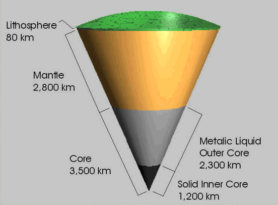
The Earth consists of an iron-rich core with a radius of 3,500 km (2,100 miles), surrounded by a 2,800-km- (1,680-mile-) thick mantle of mostly silicon, magnesium, and oxygen, and finally an 80-km- (50-mile-) thick lithosphere. While 96% of the volume of the core is liquid, there is a solid inner core with a radius of 1,200 km (720 miles). Electric currents within the metallic-liquid outer core create the Earth's magnetic field. This magnetic field is oriented approximately parallel to the rotation pole of the Earth.
.
Plate Tectonics
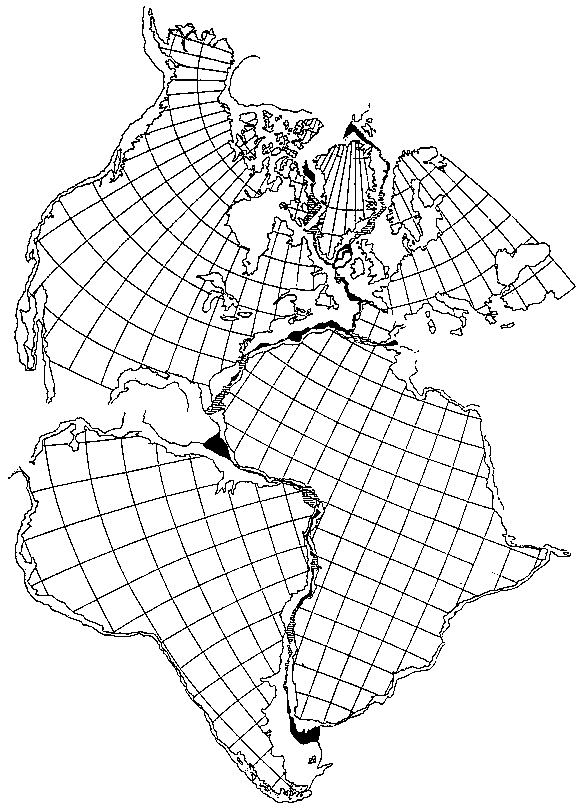
The mantle, which is much more solid than the outer core, is slowly convecting due to the increase of temperature with depth within the Earth. This motion can be compared to the convective motion of water in a pan that is being heated on a stove; however, the movement of the mantle is much, much slower. The lithosphere, the outer hard shell of the Earth, is broken into a dozen or so major pieces, called plates, and these plates are moving with respect to one another. At one time North America, South America, Europe, and Africa were joined together in one giant continent that has since broken apart to form the Atlantic Ocean Basin. The following figure (Stacy, 1977) shows how these plates once fit together.
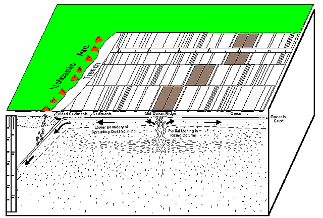
The process of sea-floor spreading created the lithosphere under the Atlantic Ocean. As North America and South America moved away from Europe and Africa, the resulting crack was filled by mantle material, which cooled and formed new lithosphere. The process continues today. Molten mantle materials continually rise to fill the cracks formed as the plates move slowly apart from each other. This process creates an underwater mountain chain, known as a mid-ocean ridge, along the zone of newly forming lithosphere.
Magnetic Stripes
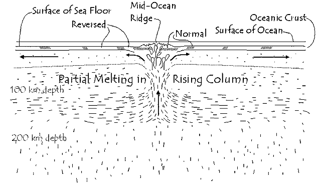
Molten rock erupts along a mid-ocean ridge, then cools and freezes to become solid rock. The direction of the magnetic field of the Earth at the time the rock cools is "frozen" in place. This happens because magnetic minerals in the molten rock are free to rotate so that they are aligned with the Earth's magnetic field. After the molten rock cools to a solid, these minerals can no longer rotate freely. At irregular intervals, averaging about 200-thousand years, the Earth's magnetic field reverses. The end of a compass needle that today points to the north will instead point to the south after the next reversal. The oceanic plates act as a giant tape recorder, preserving in their magnetic minerals the orientation of the magnetic field present at the time of their creation. Geologists call the current orientation "normal" and the opposite orientation "reversed."
In the figure below, two plates are moving apart. A mid-ocean ridge marks the location where molten rocks are moving up, cooling, and forming new ocean floor. The zones of normal magnetization are indicated by ////// shading of the oceanic crust.
The figure below shows the observed magnetic pattern along the mid-Atlantic Ridge south of Iceland. This figure is from the excellent publication "A Teacher's Guide to the Geology of Hawaii Volcanoes National Park" (Mattox, 1992), which is available on the World Wide Web at http://volcano.und.nodak.edu/vwdocs/vwlessons/plate_tectonics/part9.html. The Guide starts at http://volcano.und.nodak.edu/vwdocs/vwlessons/atg.html .

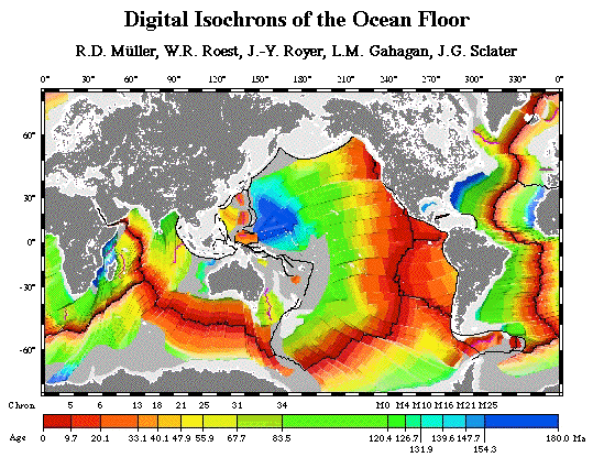
Based on the pattern and spacing of the oceanic magnetic stripes and the inferred motion of the plates, the age of the ocean floor can be determined. In the figure below by Müller and others (1997) ( http://gdcinfo.agg.emr.ca/app/jgr_paper.html ), the age of the ocean floor is depicted by colors (http://gdcinfo.agg.emr.ca/app/images/agemap.GIF ).
Convergent Margins
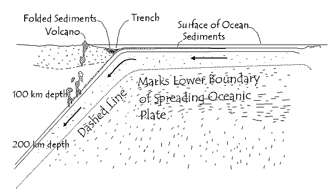
In some places, oceanic plates collide with continental plates. When this occurs, the heavier oceanic lithosphere sinks beneath the continental plate. This process, called subduction, creates a very deep trough near the line of contact between the oceanic and continental plates. This trough is called an oceanic trench. As an oceanic plate is subducted into the Earth it is subjected to increased pressure and temperature. These conditions cause some lightweight materials to melt and rise to the surface to form volcanoes. As a result, long chains of volcanoes, called volcanic arcs, are located above subducted plates, usually above the location where the plate has reached a depth of about 100 km.
Earthquakes
Geologic deformation is usually very slow, measured in centimeters per year, so the dynamic processes that continually reshape the Earth are, for the most part, unnoticed. Earthquakes are an occasional reminder that this deformation is indeed taking place, and infrequent, but potentially damaging, large earthquakes pose a hazard that is all too often ignored.
Earthquakes occur wherever two plates slip past one another, such as along the San Andreas Fault in California. This type of faulting is called "strike-slip." Earthquakes also occur where one plate slides under the other, as is happening in southern Alaska. "Thrust" earthquakes have been responsible for the two largest earthquakes ever recorded, the 1960 M 9.5 Chile earthquake and the 1964 M 9.2 Alaska earthquake. Pull-apart earthquakes occur where the lithosphere is being stretched, such as along mid-ocean ridges. These earthquakes generate "normal-faulting" events. When two ridges are connected by a fault, this is called a transform fault, and the fault is the source of strike-slip events.
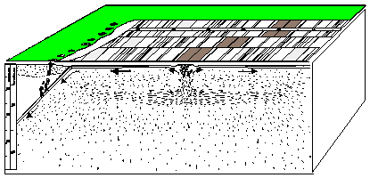
When completed, your model will look something like the figure below. Follow the directions on the following pages to complete the model. Coloring with paint or magic markers can be
added to enhance the model. Note that the shaded portions of the sea floor have the same magnetization as today, while the unshaded portions have reversed magnetization.
Operation of the Model
Slide the sea floor into the three slits in the shoebox and pull it down from underneath so that the numbers "4" are just visible. Slide the sea floor into the trench as well. This is the position the sea floor would have had 4 million years ago. Now slowly pull down with one hand on the sea floor beneath the trench, while pulling with the other hand on opposite end of the sea floor. As the sea floor diverges at the ridges, new sea floor will continually appear until the dark gray bands indicating the current epoch of normal magnetic polarity have been revealed.
Now move the sea floor back to the 4 my before present position, and this time, while the sea floor is moving, watch the boundaries where slip is occurring. Where would the three styles of earthquake -- namely thrust, normal, and strike-slip -- occur?
The USGS National Earthquake Information Center has placed seismicity maps for many regions of the World on their World Wide Web site: http://gldss7.cr.usgs.gov/neis/general/seismicity/seismicity.html . Look at some of these maps and see if you can tell where the plate boundaries are located. Where are the deepest earthquakes located and why are they there?
From the ages of the sea floor and the scale of the model, which is the same in the vertical and horizontal directions, one can determine that the plate in this model is being subducted at a rate of about 50 km/my. This works out to 5 cm/y, which is within the 1 to 10 cm/y range that most plates are moving. As an interesting comparison, this is about the rate that fingernails grow!
Suggested Additional Reading
Kious, W. J., and Tilling, R I., 1992, This Dynamic Earth, The Story of Plate Tectonics, U. S. Geological Survey, Booklet 92-TDE, 77 p.
This publication can be found on the World Wide Web at https://pubs.usgs.gov/publications/text/dynamic.html .
Acknowledgements
The author would like to acknowledge the careful reviews by E. Cranswick and P. Detra. In particular, the latter's suggestion to reduce the size of the model to that of a shoebox was most helpful.
References
Mattox, S. R., 1992, A teacher's guide to the geology of Hawaii Volcanoes National Park, published by the Hawaii Natural History Association, P.O. Box 74, Hawaii National Park, HI 96718, (808) 967-7604.
Müller, R. D., Roest, W. R., Royer, J.-Y., Gahagan, L. M., and Sclater, J. G., 1997, Digital isochrons of the World's ocean floor, Journal of Geophysical, V. 102 (B2), p. 3211-3214.
Stacey, F. D., 1977, Physics of the Earth, John Wiley & Sons, New York, 414 pages.
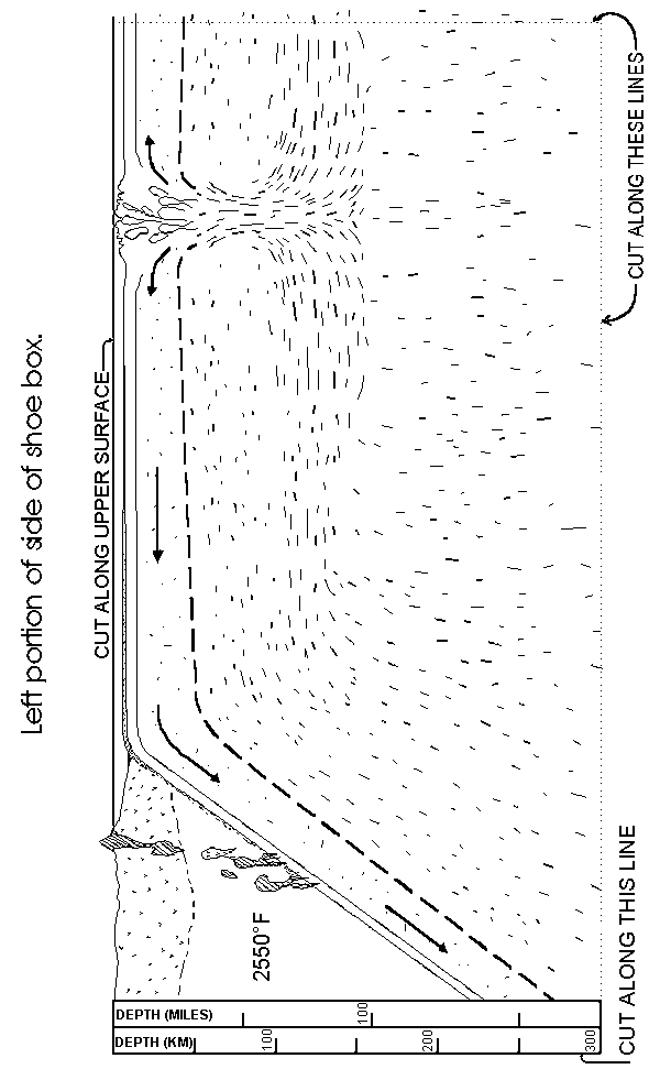
Sea-floor Spreading Model Directions
1) Use a shoe box with approximate dimensions 6.5" x 13" by 5" deep.
2) Trim as indicated the pages labeled "Left portion of side of shoe box" and "Right ...". Glue these two pages together to form the cross section through the Earth.
3) Turn the shoe box over, so that the opening is down. Glue the cross section sheets that you have just glued together to the long side of the shoe box. The surface of the ocean should be even with the top of the shoe box while the volcano
wiill stick up a bit.
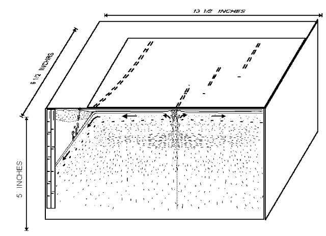
4) Trim as indicated the pattern for cutting slits in the shoe box. Orient the slit-pattern sheet as in the figure above, so that the mid-ocean ridge slit and the trench slit match the cross section on the side of the box. Cut the four slits through the shoe box. Discard the slit pattern and the four tabular pieces of cardboard from the slits.
5) Cut the four slits through the shoe box. Discard the slit pattern and the four tabular pieces of cardboard from the slits.


| AccessibilityFOIAPrivacyPolicies and Notices | |
| |
|
