
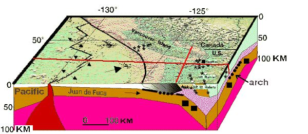
The three-dimensional image construction is being combined with seismicity patterns and other seismicity parameters, geologic information, strain models, and GPS data to provide a tectonic synthesis for the dynamics and earthquake hazards of northern Cascadia. The three-dimensional representation of the subduction zone protrayed in the diagram is based upon subsurface information from seismic reflection and magnetotelluric data, but primarily on new local earthquake tomographic models.
| Disclaimer--"Any geologic interpretations implied in the results shown on these web pages are provisional and have not received final approval from USGS administration. Users are cautioned to consider carefully the provisional nature of the information before using it for decisions that concern personal or public safety or the conduct of business that involves substantial monetary or operational consequences." |
NEW OPEN FILE REPORT:
USGS Open File Report 99-311
Subduction Zone and Crustal Dynamics of Western Washington: a Tectonic Model for Earthquake Hazards Evaluation
By Dal Stanley, Antonio Villasenor, and Harley Benz
65 pages, 64 illustrations
Available at http://geohazards.cr.usgs.gov/pacnw/ofr99-/ofr99frame.htm
Project staff:
Dal Stanley: dals@usgs.gov
Harley Benz: benz@usgs.gov
Antonio Villasenor: antonio@gldvisitor.cr.usgs.gov
Acknowledgements
All earthquake data used in the velocity modeling and in seismicity studies was obtained from the Pacific Northwest Seismic Network. Most of the maps were made with Generic Mapping Tools (GMT).
|
Return to: PACNW | Earthquake Hazards | Central Region | USGS |
|
Comments? email: dals@usgs.gov |