
DEPARTMENT OF THE INTERIOR
U. S. GEOLOGICAL SURVEY
BY B. A. MORGAN, G. IOVINE, P. CHIRICO, AND G. F. WIECZOREK
OPEN-FILE REPORT 99-518
1999
This report is preliminary and has not been reviewed for conformity with U. S. Geological Survey editorial standards (or with the North American stratigraphic code). Any use of trade, product, or firm names is for descriptive purposes only and does not imply endorsement by the U. S. Government.
INTRODUCTION
On the night of August 19/20, 1969, the remnants of Hurricane Camille, moving east across the Appalachian mountains from the Gulf Coast, stalled against a high pressure system in central Virginia. Within an 8-hour period at least 71 cm (28 in) of rain fell resulting in one of the worst natural disasters in the State in nearly 400 years of recorded history. The intense rain produced debris flows and severe flooding that claimed 150 lives, most of them in Nelson County. The debris flows and floods extensively damaged roads, bridges, communication systems, houses, farms, and livestock. The widespread death and destruction and the efforts of individual citizens and organizations in responding to the calamity are graphically chronicled in Torn Land (Simpson and Simpson, 1970).
Meteorologic and hydrologic investigations and a survey of storm damage including landslides began immediately after the event (VDMR, 1969; Webb and others, 1970; DeAngelis and Nelson, 1969; Camp and Miller, 1970) so that the distribution of landslides and the quantity of rainfall and response of streams and rivers to the deluge are moderately well known. Erosion and deposition characteristics (Williams and Guy, 1973), studies of recurrence of debris flow activity using C14 ages of ancient debris-flow deposits (Kochel, 1987) , and linkages of debris flow activity with bedrock geology (Gryta and Bartholomew, 1989) were published in the following decades. During this period, debris-flow investigations elsewhere (Campbell, 1975; Costa and Wieczorek, 1987) provided a framework for further analysis of the Nelson County disaster and a basis for its comparison with similar events in other areas.
Since 1969, Virginians have had additional opportunities to learn about and experience the hazards of debris flows in their State. In 1985, storms and intense rainfall resulted in debris flows and widespread damage in the Upper Potomac and Cheat River Basins of West Virginia and Virginia (Jacobson and others, 1989); and again in 1995, a series of storms during a single week resulted in debris flows and damage in central Virginia including Madison County (Wieczorek and others, 1996; in press), in western Albemarle County (Morgan and Wieczorek, 1996), and near the towns of Buena Vista and Front Royal. Wieczorek and others (1996) and Morgan and others (1997) have used GIS techniques to model debris-flow hazards within the Madison, Virginia, area.
This report presents a digitally based inventory of debris flows and floods in the Lovingston, Virginia, and Horseshoe Mountain, Va., 7.5" quadrangles in Nelson County, Virginia resulting from Hurricane Camille and based on areal photography taken on August 25, 1969, and April 27, 1971. This study was undertaken to provide a basis for detailed analysis of both terrain and failure sites using GIS techniques not available to earlier studies. The data to be collected and studied will include terrain slope, aspect, and elevation, drainage characteristics, soil and rock types, and estimated permeability of soils and rocks. The analysis will provide data for a model for the Appalachian Mountains of central Virginia that will address problems of location, recurrence, and conditions leading to the triggering of debris flows.
The authors are grateful to Professor Allen Howard, University of Virginia for the use of his collection of aerial photographs of the Nelson County area used to construct the accompanying map, and to Thomas Gathright, Virginia Division of Mines, for permission to examine his collection of photographs of Nelson County taken several weeks after the 1969 storm. This work was partially supported through a CNR (Consiglio Nazionale delle Ricerche) International Scholarship (203.05.18-1996) to Giulio Iovine, one of the authors.
PHYSIOGRAPHY AND GEOLOGY
The area impacted by the August 1969 storm is within the Blue Ridge Geologic Province, and is underlain by Grenville-age rocks (1.0 to 1.1 billion years old) in the core of the Blue Ridge anitclinorium. The entire region shown on the accompanying map of the Lovingston and Horseshoe Mountain, Va., 7.5' quadrangles is rugged and intensely dissected with steep slopes and poorly defined ridges. There are only a few hills above 2,500 feet, which is in marked contrast to the more elevated Blue Ridge about 5 miles to the west with continuous elevations above 3,500 feet. The area is sparsely populated, agriculture is limited to stream valleys, orchards are confined to more gentle slopes, and much of the entire region is densely forested.
The bedrock geology of the region has been summarized by Sinha and Bartholomew (1984), Gryta and Bartholomew (1989), and Evans (1991). The principal geologic unit in the two quadrangles is the Lovingston massif, Grenville age (1.0 to 1.1 Ga) gneissic rocks metamorphosed in the lower granulite-amphibolite facies with a strong Paleozoic greenschist-facies overprint. Many of the rocks are layered or foliated with abundant biotite and/or amphibole. Massive granulite gneiss and charnockite are present in smaller isolated bodies within the terrain. The Lovingston massif is juxtaposed against the Pedlar massif along the Rockfish Valley fault, a major zone of Proterozoic and Paleozoic deformation. This fault has a trace northwest of Horseshoe Mountain along the general trend of Cub Creek. The Pedlar massif, also of Grenville age, is a terrane of upper-granulite facies metamorphic rocks, and is generally massive. It is overlain by the Late Proterozoic Catoctin Formation, dominantly composed of metabasalts, and the Lower Cambrian Chilhowie Group, dominantly composed of siliclastic rocks, both highly resistant to erosion and forming the principal rocks of the more elevated Blue Ridge.
The surficial geology of the region has not been mapped in detail although it is well characterized by Kochel (1987). Prolonged exposure to a warm, humid climate during the 10,000 years since the last Aice age@ has produced a thin regolith of saprolite and colluvium, which mantles most of the hill summits and slopes. The thick colluvium, including stratified slope wash and talus that characterizes the higher Blue Ridge (Whittecar and Ryter, 1992, Morgan, 1998), does not appear to be widely distributed in the Lovingston and Horseshoe Mountain quadrangles. During the storm of August 1969, failures on steep slopes took place most frequently on the interface between colluvium and bedrock, resulting in steep surfaces of exposed bedrock, still quite visible after nearly 30 years. Deposition from both prehistoric and 1969 debris flows has built many small fans, which are irregular in plan view due to valley wall confinement. The fans generally are less than 20 m (66 ft) thick and are not thicker because of (1) a limited supply of debris from basins with limited colluvium, (2) removal of material by previous stream action, and (3) frequency of debris-flow activity which occurs once every 3,000 to 4,000 years (Kochel, 1987). The one large composite fan is in the Lesene State Forest, in the northwest corner of the Horseshoe Mountain, Va quadrangle, an area almost unaffected by debris-flows in the 1969 storm.
METEOROLOGY OF THE 1969 STORM
Hurricane Camille, one of the most powerful storms recorded by the U.S. Weather Service, struck the Gulf Coast on the night of August 17, 1969. Winds of up to 190 mph were experienced at Bay St. Louis, Mississippi, and winds of 150 mph or more were felt over a broader area east of Biloxi, Mississippi. The hurricane weakened as it moved inland across Mississippi, Tennessee, Kentucky, and West Virginia during August 17-19. Rain falling over this area decreased from about 8 inches in southern Mississippi to less than 2 inches in Kentucky. However, the storm again intensified as it crossed the Appalachian Mountains into Virginia on August 19, merging with a band of heavy showers and thunderstorms that had moved into the area from the north and northwest earlier in the day. Heavy, steady rain began to fall at Montebello, Nelson County, by 7 p.m. The steady rain continued for 8 hours at many locations. By 10 pm EDT, a band of rain about 40 to 50 miles wide extended from White Sulphur Springs, West Virginia to Fredericksburg, Virginia. By about midnight, rain continued to intensify on the eastern slopes of the Blue Ridge reaching Acatastrophic cloudburst proportions@ (Camp and Miller, 1970). Rainfall of 12-14 inches was widespread in Nelson County and the southern part of Albemarle County. Reliable evidence of 27-28 inches of rain fell in the central part of Nelson County with an unconfirmed report of 31 inches of rain (Camp and Miller, 1970), all during an 8-hour period.
Isohyetal plots of rainfall at a small scale (Camp and Miller, 1970) and at a much larger scale by Kochel (1987), based on data collected by the National Weather Service (DeAngelis and Nelson, 1969; Schwarz, 1970) and field data collected and reported by Camp and Miller (1970)
indicate that rainfall maximums from the August 19-20 storm fell near Tyro and in the southern part of the Horseshoe Mountain quadrangle, both well to the west of maximum debris-flow activity. Gryta and Bartholomew (1989) have extensively analyzed the isohyetal patterns as reported by Kochel and related these to bedrock geology and to debris-flow occurrences. However, a reinvestigation of the data of Camp and Miller (1970) shows that no unique solution for contouring the isohyets for the storm in Nelson County can be obtained because many of the total rainfall determinations are minimums. The buckets, milk pails, and other open containers used to measure the rainfall overflowed and the total rainfall is not known. All of the critical measurements in the area of Davis Creek are minimum amounts, an area of intense ground failure and flooding. Figure 1 is a replot of the isohyets using data from Camp and Miller (1970) and shows contours that are permissible from the available data, but not uniquely determined. The 10- inch isohyet is moderately well defined, and the 20- and 25-inch isohyets mimic the form of the ten-inch isohyet and do not violate any of the minimum rainfall determinations. The result is a plausible interpretation that has the merit of placing the Davis Creek area in the center of the rainfall maximum rather than to the east of the maximum.
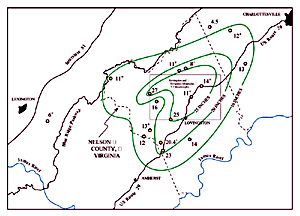
Figure 1. Isohyets for total rainfall from Hurricane Camille, August 19 and 20, 1969 in Nelson County, Virginia. Rainfall measurements plotted are in inches and are taken from Camp and Miller (1970). Plus signs indicate that rain gauges overflowed and only minimum rainfall is known.
INVENTORY OF STORM EFFECTS
The accompanying map shows areas affected by debris flows and flooding resulting from the August 1969 storm in Nelson County. Stereoscopic pairs of aerial photographs were used to make line drawings of debris-flow and flood effects. These were transferred to mylar overlying stable base maps of the Lovingston, Va., and Horseshoe Mountain, Va., 7.5' topographic quadrangles. The lines were then scanned, imported into ARCINFO, and digitally edited into layers of debris flows and flood effects. Because no digital line graphs (DLG=s) are available at 1:24,000 scale for either quadrangle, digital raster graphics (DRG=s) for these quads were used as the base map for plots of the debris flows and flood effects. DRG=s are scanned 7.5' topographic quadrangles which are then digitally projected into a specific map projection. For this project both the DRG=s and the debris flow and flood effect plots are projected in UTM Zone 17, NAD 83. Exact superposition of the two data sets is good to excellent throughout the area of the two quadrangles.
Inspection of the accompanying map reveals that the interfluve between the Tye and Rockfish Rivers, about 65 square miles, was completely devastated by debris flows and floods. Thousands of failure sites can be identified on areal photographs and almost every first-order drainage channel became the chute of a debris flow. The majority of failures resulted in short slides or debris flows with short travel distances, but there are several major exceptions. Davis Creek and Freshwater Cove experienced many debris flows throughout their drainage basins that coalesced in the stream valley with run-out distances exceeding 2 miles. Considering the size and path of Hurricane Camille, it is remarkable that the devastation depicted in plate 1 is so complete and so restricted in total area. Within the area most affected, slope angle and runoff influenced the distribution of failure sites more than other factors such as bedrock geology.
COMPARISON WITH OTHER STORMS IN VIRGINIA RESULTING IN DEBRIS FLOWS
Storms producing debris flows in Virginia have occurred about every 15 years over the last half century. It is uncertain if this average recurrence is typical over longer periods; most debris flows occur in mountainous regions which were sparsely populated and records are not available. Floods affecting larger areas and many people downstream have been more commonly reported. It is also difficult to determine the effect of climate change from the Late Pleistocene to the present on the frequency and magnitude of storms affecting the Blue Ridge. Local average recurrences (where the local Asite@ is approximately 50 square miles), based on C14 dating of prehistoric debris flows (Kochel, 1987; Eaton and McGeehin, 1997), are on the order of 2,000-3,500 years. In the 20th century, the recurrence of storms producing debris flows in the Appalachian Mountains of Virginia, a much larger area of over 18,000 square miles, has been on the order of every one or two decades.
The Nelson County storm of August 1969 is similar in many aspects to the devastating storm that struck Madison County in June 1995. The size of the affected area, the total amount of rainfall, the duration, and the intensity of rainfall are all similar. The meteorology of the June 1995 storm was described by Smith and others (1996), maps showing the debris flows, floods, isohyets, and hazards have been prepared by Morgan and others (1999), and an analysis of the storm prepared by Wieczorek and others (in press). Although the number of sites affected in Madison County was large with over 1,000 failures and numerous debris flows, devastation does not appear to have been as complete as within the central area affected by the Nelson County storm. Debris flows in the Madison area, though less numerous, appear to be larger with longer average run outs. Subtle differences in the topography probably played a major role. For example in comparing the two areas, the Nelson County area has steeper slopes and is more dissected, but topographic relief is much less.
MITIGATION OF DEBRIS FLOW HAZARDS
Although debris flows resulting from excessive rainfall appear to be relatively rare events at a given locality, the total public and private cost averages millions of dollars annually. The storm in August 1969 killed 150 people, including about 1 percent of the citizens of Nelson County, a rural and sparsely settled area. Although neither storms nor debris flows can be prevented, effective mitigation measures can be taken to reduce risks to people and loss of property.
The first measure consists of education and widespread information dissemination about the causes and dangers of floods and debris flows resulting from major rainfall. Some knowledge of the expected path of debris flows would result in better informed evacuation plans, providing citizens with some knowledge of safe areas for refuge. Without adequate public education, further measures will not be taken nor will warnings be heeded.
The second measure involves enaction of informed and respected zoning restrictions on land subject to debris-flow and flood hazards. These restrictions could reduce loss of life and property through recognition that debris flows are triggered on steep slopes and move rapidly into existing stream channels. Although failures may be modest at the triggering sites, material is entrained into the flow downslope so that the debris flow becomes larger and more dangerous as it moves down slope into higher order streams. Knowledge of the behavior of debris flows, their expected paths, and areas which are at risk from debris flow activity are the principal tool for making zoning restrictions. Other mitigation measures involving land use should include a careful study of the placement of roads, bridges, and power lines so that, as these structures are rebuilt or rerouted, disruption of communications and transportation during and after major storms can be minimized.
The third measure involves early warning based on predicted rainfall and upstream measurement of intense rainfalls exceeding 2 inches/per hour for more than 4 hours. If both evacuation plans and a warning system had been in place in Nelson County during 1969, the citizens along Davis Creek would have been advised just before midnight of August 19 to seek refuge at a nearby structure not in the path of streams draining steep slopes, such as the Oak Hill Church. Had all the citizens heard and heeded this warning, most or all of the 50 fatalities in that one area could have been avoided.
REFERENCES
Camp, J.D., and Miller, E.M., 1970, Flood of August 1969 in Virginia: U. S. Geological Survey Open File Report, 120 p.
Campbell, R.H., 1975, Soil slips, debris flows, and rainstorms in the Santa Monica Mountains and vicinity, southern California: U. S. Geological Survey Professional Paper 851, 51 p.
Costa, J.E. and Wieczorek, G.F., editors, 1987, Debris flows/avalanches; process recognition, and mitigation; Geological Society of America Reviews in Engineering Geology, v. 7, 239 p.
DeAngelis, R.M., and Nelson, E.R., 1969, Hurricane Camille, August 5-22: U.S. Department of Commerce, ESSA=s Climatological Data, National Summary, v. 20, no. 8, p. 451-474.
Eaton, L.S., and McGeehin, J.P., 1997, Frequency of debris flows and their role in long term landscape evolution in the central Blue Ridge: Geological Society of America. Abstracts with Programs, Annual Meeting, Salt Lake City, p. 410.
Evans, N.H., 1991, Latest Precambrian to Ordovician metamorphism in the Virginia Blue Ridge: origin of the contrasting Lovingston and Pedlar basement terranes: American Journal of Science, v. 291, p. 425-452.
Gryta, J.J., and Bartholomew, M.J., 1989, Factors influencing the distribution of debris avalanches associated with the 1969 Hurricane Camille in Nelson County, Virginia: in Landslide processes of the eastern United States and Puerto Rico: Schultz, A.P. and Jibson, R.W., editors, Geological Society of America Special Paper 236, p. 15-28.
Jacobson, R.B., ed. 1993, Geomorphic studies of the storm and flood of November 3-5, 1985, in the upper Potomac and Cheat River Basins in West Virginia and Virginia: U. S. Geological Survey Bulletin 1981.
Kochel, R.C., 1987, Holocene debris flows in central Virginia: in Costa, J.E., and Wieczorek, G.F., editors, Debris flows/avalanches; process recognition, and mitigation: Geological Society of America Reviews in Engineering Geology, v. 7, p. 139-155.
Morgan, B. A., 1998, Surficial geology of Shaver Hollow, Shenandoah National Park: U.S. Geological Survey Open File Report 98-343, 13 p.
Morgan, B.A., and Wieczorek, G.F., 1996, Inventory of Debris Flows and Landslides Resulting from the June 27, 1995 Storm on the North Fork of the Moormans River, Shenandoah National Park, Virginia: U.S. Geological Survey, Open File Report 96-503.
Morgan, B.A., Wieczorek, G.F., Campbell, R.H., and Gori P.L., 1997, Debris Flow Hazards in Areas Affected by the June 27, 1995, Storm in Madison County, Virginia: U.S. Geological Survey, Open File Report 97-438, 15 p, 2 plates, scale 1:24,000..
Morgan, B.A., Wieczorek, G.F., and Campbell, R.H.,1999, Map of rainfall, debris flows, and flood effects of the June 27, 1995 storm in Madison County, Virginia: U.S. Geological Survey Investigations Map I -2623-A, scale 1:24,000.
Morgan, B.A., Wieczorek, G.F., and Campbell, R.H., 1999, Historical and potential debris- flow hazard map of the area affected by the June 27, 1995, storm in Madison County, Virginia: U. S. Geological Survey Investigations Map I - 2323-B, scale 1:24,000.
Schwarz, F.K., 1970, The unprecedented rains in Virginia associated with the remnants of Hurricane Camille: Monthly Weather Review, v. 98, no. 11, p. 851-859.
Simpson, P.S. and Simpson, J.H., Jr., 1970, Torn Land: J.P. Bell Co., Lynchburg, VA, 429 p.
Sinha, A.K., and Bartholomew, M.J., 1984, Evolution of the Grenville terrane in the central Virginia Appalachians, in Bartholomew, M.J. Force, E.R. Sinha, A.K., and Herz, N., eds.,
The Grenville event in the Appalachians and related topics: Geological Society of America Special Paper 194, p. 175-186.
Smith, J.A., Baeck, M.L., and Steiner, Matthias, 1996, Catastrophic rainfall from an upslope thunderstorm in the central Appalachians: The Rapidan storm of June 27, 1995: Water Resources Research, v. 32, no.10, p. 3099-3113.
VDMR (Virginia Division of Mineral Resources), 1969, Natural features caused by a catastrophic storm in Nelson and Amherst Counties, Virginia: Virginia Minerals Special Issue, 20 p.
Webb, H.W., Nunan, W.E., and Penley, H.M., 1970, Road log - storm damaged areas in central Virginia: Virginia Minerals, v. 16, no. 1, p. 1-10.
Whittecar, G.R., and Ryter, D.W., 1992, Boulder streams, debris fans, and Pleistocene climate change in the Blue Ridge Mountains of Central Virginia: Journal of Geology, v. 100, p. 487-494.
Wieczorek, G.F., Morgan, B.A., Campbell, R.H., Orndorff, R.C., Burton, W.C., Southworth, C.S., and Smith, J.A., 1996, Preliminary Inventory of Debris-Flow and Flooding Effects of the June 27, 1995, Storm in Madison County, Virginia, Showing Time Sequence of Positions of Storm Cell Center: U. S. Geological. Survey, Open File Report 96-13.
Wieczorek, G.F., Morgan, B.A., and Campbell, R.H., in press, Debris-flow hazards in the Blue Ridge of central Virginia: the storm of June 27, 1995 in Madison county Virginia: Journal of Environmental and Engineering Geosciences, 24 ms pl, 20 figs.
Williams, G.P. and Guy, H.P., 1973, Erosional and depositional aspects of Hurricane Camille in Virginia, 1969: U. S. Geological Survey Professional Paper 804, 80 p.
| AccessibilityFOIAPrivacyPolicies and Notices | |
| |
|