Land and Federal mineral ownership coverage for southern
Wyoming
|
 |
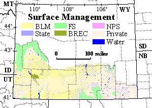
This Arc/Info coverage contains land status and Federal mineral ownership
for approximately 37,800 square miles in southern Wyoming. The polygon
coverage (which is also provided here as a shapefile) contains two attributes
of ownership information for each polygon. One attribute indicates
where the surface is State owned, privately owned, or, if Federally owned,
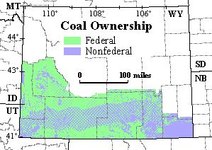
which Federal agency manages the land surface. The other attribute
indicates which minerals, if any, are owned by the Federal govenment. This
coverage is based on land status and Federal mineral ownership data compiled
by the U.S. Geological Survey (USGS) and the Wyoming State Bureau of Land
Management (BLM) at a scale of 1:24,000. This coverage was compiled primarily
to serve the USGS National Oil and Gas Resource Assessment and National
Coal Resource Assessment Projects in the Northern Rocky Mountains/Great
Plains Region.
Download the Arc/Info EXPORT file http://greenwood.cr.usgs.gov/pub/open-file-reports/ofr-99-0553-c/swy_own.e00
{NOTE: to download rather than open the file, right mouse click on the
filename. This opens a window from which the user selects 'Save Link
As...' (Netscape Navigator) or 'Save Target As...' (Internet Explorer)
to save the file to the desired location. Approximate file size is
19.5 MB.}
Download the shapefile and ArcView project file http://greenwood.cr.usgs.gov/pub/open-file-reports/ofr-99-0553-c/swy_own.zip.
The shapefile (5 files) and a .apr file for ArcView3.1 are contained in
a WinZip file. {NOTE: right mouse click on the filename. This opens
a window from which the user selects 'Save Link As...' (Netscape Navigator)
or 'Save Target As...' (Internet Explorer) to save the file to the desired
location. A left mouse click sends the file to c:\My Downloadable
Files. Approximate file size of the WinZip file is 8.7 MB; once extracted,
the files use approximately 27 MB of space.}
Download the metadata in text format that is FGDC compliant http://greenwood.cr.usgs.gov/pub/open-file-reports/ofr-99-0553-c/swy_own.met.
(Approximate file size is 25 KB.)
Disclaimer: The surface and mineral management status are published
as general planning and management tools. The official land records in
Bureau of Land Management (BLM) offices or other Federal and/or State agencies
should be checked for status of specific tracts of land. Comparison with
other data sets on surface and mineral ownership for the same area from
other time periods may reveal inconsistencies resulting from changes in
land and mineral ownership or in mapping conventions over time. This data
is not a legal document and is not intended to be used as such. Any use
of trade, product, or company names in this publication is for descriptive
purposes only and does not imply endorsement by the U.S. Government.
Metadata:
-
Identification_Information:
-
Citation:
-
Citation_Information:
-
Originator: U.S. Geological Survey
-
Originator: Biewick, L.R.H.
-
Originator: Mercier, T.J.
-
Originator: Taber, T.
-
Originator: Urbanowski, S.R.
-
Originator: Bureau of Land Management
-
Originator: Neasloney, L.
-
Publication_Date: 19990000
-
Title:
-
swy_own (Land and Federal mineral ownership coverage for So. Wyoming)
-
Geospatial_Data_Presentation_Form: map
-
Publication_Information:
-
Publication_Place: Denver, CO
-
Publisher: U.S. Geological Survey
-
Online_Linkage: <http://greenwood.cr.usgs.gov/pub/open-file-reports/ofr-99-0553-c/>
-
Description:
-
Abstract:
-
This Arc/Info coverage contains land status and Federal mineral ownership
for approximately 37,800 square miles in southern Wyoming. The polygon
coverage (which is also provided here as a shapefile) contains two attributes
of ownership information for each polygon. One attribute indicates where
the surface is State owned, privately owned, or, if Federally owned, which
Federal agency manages the land surface. The other attribute indicates
which minerals, if any, are owned by the Federal govenment. This coverage
is based on land status and Federal mineral ownership data compiled by
the U.S. Geological Survey (USGS) and the Wyoming State Bureau of Land
Management (BLM) at a scale of 1:24,000. This coverage was compiled
primarily to serve the USGS National Oil and Gas Resource Assessment and
National Coal Resource Assessment Projects in the Northern Rocky Mountains/Great
Plains Region.
-
Purpose:
-
As United States energy resources continue to be examined for potential
development, there is sustained interest in Federally owned energy resources
in the western United States. The U.S. Geological Survey's GIS data sets
of surface and Federal mineral ownership, joined with USGS geologic investigations,
provides information on where Federally owned energy resources are located
and how much Federal petroleum and coal exists. These ownership and resource
data are the basis for answering complex geospatial queries when the data
are combined with quality, structure and other parameters generated from
geologic investigations. Combining information on land status, Federal
mineral status, and geology helps policy makers and land-use planners make
informed decisions regarding use of Federal land and energy resources to
meet diverse social needs.
-
Surface ownership can differ from energy and other mineral ownership for
the same piece of land. For example, the oil and gas may be Federally owned,
but the surface may be under the jurisdiction or management of State, Tribal,
or private groups. This separation of jurisdiction may have legal ramifications
in the development or non-development of energy resources.
-
The U. S. Geological Survey (USGS), in cooperation with the Bureau of Land
Management (BLM) and State agencies, is collecting ownership files and
compiling them in Arc/Info coverages. The coverages contain a USGS standardized
attributing scheme and are stored in a data library where they are accessed
and combined with models of oil, gas and coal geology to assess National
energy resources (see information from the U.S. Geological Survey available
on 10/5/99 on the World Wide Web at <URL:http://energy.cr.usgs.gov/fedland/FS12-98/>
and at <URL:http://greenwood.cr.usgs.gov/pub/fact-sheets/fs-0145-99/>).
Similar data are being created in northeastern Utah (in press) and in northwestern
Colorado (in press) primarily to serve the U.S. Geological Survey National
Oil and Gas Resource Assessment Project in the Uinta-Piceance Basin (province
20).
-
The Federally owned energy resources play an important role in supplying
energy to our Nation. The Bureau of Land Management (BLM) in Wyoming manages
approximately 11 million acres of subsurface mineral estate. Wyoming routinely
leads the nation in production of low-sulfur coal. Federal leases in Wyoming
produced 248,866,650 tons of coal in 1998 (information from the Bureau
of Land Management available on 8/10/99 on the World Wide Web at
<URL:http://www.wy.blm.gov/minerals/minerals.html>.)
Federally owned energy resources also play an important part in the economy
of our Nation. Oil and gas operations on public land generated $159,675,604
in royalties in 1998. Half of this goes to the Federal treasury, with the
remaining to the State of Wyoming (information from the Bureau of Land
Management available on 8/10/99 on the World Wide Web at
<URL:http://www.wy.blm.gov/minerals/minerals.html>.)
-
Time_Period_of_Content:
-
Time_Period_Information:
-
Single_Date/Time:
-
Calendar_Date: 19990628
-
Currentness_Reference: completion date
-
Status:
-
Progress: Complete
-
Maintenance_and_Update_Frequency: Unknown
-
Spatial_Domain:
-
Bounding_Coordinates:
-
West_Bounding_Coordinate: -111.0445
-
East_Bounding_Coordinate: -104.0519
-
North_Bounding_Coordinate: 43.4748
-
South_Bounding_Coordinate: 40.9968
-
Keywords:
-
Theme:
-
Theme_Keyword_Thesaurus: None
-
Theme_Keyword: Wyoming
-
Theme_Keyword: Federal mineral ownership
-
Theme_Keyword: land status
-
Theme_Keyword: land ownership
-
Theme_Keyword: land-use planning
-
Theme_Keyword: Federal coal ownership
-
Theme_Keyword: Federal oil and gas ownership
-
Theme_Keyword: Federal surface management
-
Theme_Keyword: Surface management
-
Theme_Keyword: Public lands
-
Place:
-
Place_Keyword_Thesaurus: None
-
Place_Keyword: Hanna Basin
-
Place_Keyword: southern Wyoming
-
Place_Keyword: western United States
-
Place_Keyword: Green River Basin
-
Place_Keyword: Bridger Basin
-
Place_Keyword: Province 37
-
Place_Keyword: Southwestern Wyoming Province
-
Place_Keyword: Province 36
-
Place_Keyword: Wyoming Thrust Belt Province
-
Place_Keyword: Province 39
-
Place_Keyword: northern Denver Basin Province
-
Place_Keyword: Washakie Basin
-
Place_Keyword: Laramie Basin
-
Place_Keyword: northern Denver Basin
-
Place_Keyword: Shirley Basin
-
Place_Keyword: Red Desert Basin
-
Place_Keyword: Hoback Basin
-
Temporal:
-
Temporal_Keyword_Thesaurus: None
-
Temporal_Keyword: 1999
-
Access_Constraints: None
-
Use_Constraints:
-
The surface and mineral management status are published as general planning
and management tools. The official land records in Bureau of Land Management
(BLM) offices or other Federal and/or State agencies should be checked
for status of specific tracts of land. Comparison with other data sets
on surface and mineral ownership for the same area from other time periods
may reveal inconsistencies resulting from changes in land and mineral ownership
or in mapping conventions over time.
-
Point_of_Contact:
-
Contact_Information:
-
Contact_Person_Primary:
-
Contact_Person: Laura R.H. Biewick
-
Contact_Organization: U.S. Geological Survey
-
Contact_Position: Geologist
-
Contact_Address:
-
Address_Type: mailing and physical address
-
Address: P.O. Box 25046, MS 939
-
City: Denver
-
State_or_Province: CO
-
Postal_Code: 80225-0046
-
Country: USA
-
Contact_Voice_Telephone: (303) 236-7773
-
Contact_Facsimile_Telephone: (303) 236-0459
-
Contact_Electronic_Mail_Address: lbiewick@usgs.gov
-
Native_Data_Set_Environment:
-
Arc/Info Version 7 on UNIX operating system
-
Data_Quality_Information:
-
Attribute_Accuracy:
-
Attribute_Accuracy_Report:
-
The ownership files for southwest Wyoming and the Great Divide Resource
Area (southeast Wyoming) were provided by the BLM during 2/97. The files
were in MOSS export format in two different projections. The data were
compiled by the BLM at a scale of 1:24,000. Attributes were added and populated
in accordance with the standard attributing scheme developed by the USGS
for land status and minerals owned by the Federal Government. The attributes
were populated based on the Wyoming BLM coding scheme that is referred
to as the "pizza" code.
-
Logical_Consistency_Report: topologically clean, 6/28/99, Arc/Info
-
Completeness_Report:
-
This ownership coverage is based on land status and Federal mineral ownership
data compiled by the Wyoming State BLM office, at a scale of 1:24,000,
and is current as of 2/97.
-
Lineage:
-
Source_Information:
-
Source_Citation:
-
Citation_Information:
-
Originator: Bureau of Land Management
-
Publication_Date: 19910000
-
Title:
-
Wyoming
-
Baggs
-
Surface Management Status
-
Mineral Management Status
-
Geospatial_Data_Presentation_Form: map
-
Source_Scale_Denominator: 100,000
-
Type_of_Source_Media: paper map
-
Source_Time_Period_of_Content:
-
Time_Period_Information:
-
Single_Date/Time:
-
Calendar_Date: 19910000
-
Source_Currentness_Reference: publication date
-
Source_Contribution:
-
Land and mineral ownership in the Baggs 30- x 60-minute quadrangle, Wyoming.
-
Source_Citation_Abbreviation: BLM, 1991
-
Source_Information:
-
Source_Citation:
-
Citation_Information:
-
Originator: Bureau of Land Management
-
Publication_Date: 19880000
-
Title:
-
Surface Management Status
-
Mineral Management Status
-
Evanston
-
Wyoming
-
Geospatial_Data_Presentation_Form: map
-
Source_Scale_Denominator: 100,000
-
Type_of_Source_Media: paper map
-
Source_Time_Period_of_Content:
-
Time_Period_Information:
-
Single_Date/Time:
-
Calendar_Date: 19880000
-
Source_Currentness_Reference: publication date
-
Source_Contribution:
-
Land and mineral ownership in the Evanston 30- x 60-minute quadrangle,
Wyoming.
-
Source_Citation_Abbreviation: BLM, 1988
-
Source_Information:
-
Source_Citation:
-
Citation_Information:
-
Originator: Bureau of Land Management
-
Publication_Date: 19880000
-
Title:
-
Surface Management Status
-
Firehole Canyon
-
Wyoming-Utah-Colorado
-
Geospatial_Data_Presentation_Form: map
-
Source_Scale_Denominator: 100,000
-
Type_of_Source_Media: paper map
-
Source_Time_Period_of_Content:
-
Time_Period_Information:
-
Single_Date/Time:
-
Calendar_Date: 19880000
-
Source_Currentness_Reference: publication date
-
Source_Contribution:
-
Land and mineral ownership in the Firehole Canyon 30- x 60-minute quadrangle,
Wyoming-Utah-Colorado.
-
Source_Citation_Abbreviation: BLM, 1988
-
Source_Information:
-
Source_Citation:
-
Citation_Information:
-
Originator: Bureau of Land Management
-
Publication_Date: 19910000
-
Title:
-
Wyoming
-
Kinney Rim
-
Surface Management Status
-
Mineral Management Status
-
Geospatial_Data_Presentation_Form: map
-
Source_Scale_Denominator: 100,000
-
Type_of_Source_Media: paper map
-
Source_Time_Period_of_Content:
-
Time_Period_Information:
-
Single_Date/Time:
-
Calendar_Date: 19910000
-
Source_Currentness_Reference: publication date
-
Source_Contribution:
-
Land and mineral ownership in the Kinney Rim 30- x 60-minute quadrangle,
Wyoming.
-
Source_Citation_Abbreviation: BLM, 1991
-
Source_Information:
-
Source_Citation:
-
Citation_Information:
-
Originator: Bureau of Land Management
-
Publication_Date: 19920000
-
Title:
-
Surface Management Status
-
Mineral Management Status
-
Wyoming
-
Medicine Bow
-
Geospatial_Data_Presentation_Form: map
-
Source_Scale_Denominator: 100,000
-
Type_of_Source_Media: paper map
-
Source_Time_Period_of_Content:
-
Time_Period_Information:
-
Single_Date/Time:
-
Calendar_Date: 19920000
-
Source_Currentness_Reference: publication date
-
Source_Contribution:
-
Land and mineral ownership in the Medicine Bow 30- x 60-minute quadrangle,
Wyoming.
-
Source_Citation_Abbreviation: BLM, 1992
-
Source_Information:
-
Source_Citation:
-
Citation_Information:
-
Originator: Bureau of Land Management
-
Publication_Date: 19910000
-
Title:
-
Wyoming
-
Rawlins
-
Surface Management Status
-
Mineral Management Status
-
Geospatial_Data_Presentation_Form: map
-
Source_Scale_Denominator: 100,000
-
Type_of_Source_Media: paper map
-
Source_Time_Period_of_Content:
-
Time_Period_Information:
-
Single_Date/Time:
-
Calendar_Date: 19910000
-
Source_Currentness_Reference: publication date
-
Source_Contribution:
-
Land and mineral ownership in the Rawlins 30- x 60-minute quadrangle, Wyoming.
-
Source_Citation_Abbreviation: BLM, 1991
-
Source_Information:
-
Source_Citation:
-
Citation_Information:
-
Originator: Bureau of Land Management
-
Publication_Date: 19910000
-
Title:
-
Wyoming
-
Saratoga
-
Surface Management Status
-
Geospatial_Data_Presentation_Form: map
-
Source_Scale_Denominator: 100,000
-
Type_of_Source_Media: paper map
-
Source_Time_Period_of_Content:
-
Time_Period_Information:
-
Single_Date/Time:
-
Calendar_Date: 19910000
-
Source_Currentness_Reference: publication date
-
Source_Contribution:
-
Land and mineral ownership in the Saratoga 30- x 60-minute quadrangle,
Wyoming.
-
Source_Citation_Abbreviation: BLM, 1991
-
Source_Information:
-
Source_Citation:
-
Citation_Information:
-
Originator: Bureau of Land Management
-
Publication_Date: 19920000
-
Title:
-
State of Wyoming Land Status, 1991
-
Geospatial_Data_Presentation_Form: map
-
Source_Scale_Denominator: 1000000
-
Type_of_Source_Media: paper map
-
Source_Time_Period_of_Content:
-
Time_Period_Information:
-
Single_Date/Time:
-
Calendar_Date: 19920000
-
Source_Currentness_Reference: publication date
-
Source_Contribution: Land status of the State of Wyoming
-
Source_Citation_Abbreviation: BLM, 1992
-
Process_Step:
-
Process_Description:
-
The ownership files for southwest Wyoming and the Great Divide Resource
Area (southeast Wyoming) were provided by the BLM duirng 2/97. The files
were in MOSS export format in two different projections. The data were
compiled by the BLM at a scale of 1:24,000. Attributes were added and populated
in accordance with the standard attributing scheme developed by the USGS
for land status and minerals owned by the Federal Government. The attributes
are SURF for surface management status and FEDMINS for Federal mineral
ownership. SURF and FEDMINS were populated based on the Wyoming BLM coding
scheme that is referred to as the "pizza" code. The "pizza" code is a 5-
to 6-digit character string that defines surface and subsurface ownership,
the Federal agency with jurisdiction, and the Federal mineral reservation,
and is stored in an item, DATA. Where DATA was blank, the most current
BLM surface and mineral management status maps were referenced to populate
SURF and FEDMINS. Following is a list of the 30- x 60-minute quadrangle
maps used and the year of publication --
-
Baggs, 1991
-
Evanston, 1988
-
Firehole Canyon, 1988
-
Kinney Rim, 1991
-
Medicine Bow, 1992
-
Rawlins, 1991
-
Saratoga, 1991
-
Another map used for reference is the statewide Wyoming Land Status map
that was published in 1992 by the BLM and is current as of 1991.
-
The two coverages for SW Wyoming and SE Wyoming were projected to geographic
decimal degrees (dd) and appended. The resulting coverage was cleaned using
a fuzzy and dangle tolerance of .00002216. Polygons were extended along
the western and southern State boundaries to match the 1:100,000-scale
State lines coverage that was also used for adjoining ownership coverages
in Colorado and Utah (see <http://greenwood.cr.usgs.gov/pub/open-file-reports/ofr-99-0553-a/> and
<http://greenwood.cr.usgs.gov/pub/open-file-reports/ofr-99-0553-b/>).
There are no label errors and extraneous pseudonodes have been deleted.
The coverage was dissolved to eliminate extraneous polygons. The final
coverage contains 20241 polygons (43358 arcs).
-
Process_Date: 19990000
-
Process_Contact:
-
Contact_Information:
-
Contact_Person_Primary:
-
Contact_Person: Laura R.H. Biewick
-
Contact_Organization: U.S. Geological Survey
-
Contact_Position: geologist
-
Contact_Address:
-
Address_Type: mailing and physical address
-
Address: P.O. Box 25046, MS 939
-
City: Denver
-
State_or_Province: CO
-
Postal_Code: 80225-0046
-
Country: USA
-
Contact_Voice_Telephone: (303) 236-7773
-
Contact_Facsimile_Telephone: (303) 236-0459
-
Contact_Electronic_Mail_Address: lbiewick@usgs.gov
-
Spatial_Data_Organization_Information:
-
Direct_Spatial_Reference_Method: Vector
-
Point_and_Vector_Object_Information:
-
SDTS_Terms_Description:
-
SDTS_Point_and_Vector_Object_Type: GT-polygon composed of chains
-
Point_and_Vector_Object_Count: 20241
-
Spatial_Reference_Information:
-
Horizontal_Coordinate_System_Definition:
-
Geographic:
-
Latitude_Resolution: .0001
-
Longitude_Resolution: .0001
-
Geographic_Coordinate_Units: Decimal Degrees
-
Geodetic_Model:
-
Horizontal_Datum_Name: North American Datum 1927
-
Ellipsoid_Name: CLARKE1866
-
Semi-major_Axis: 6378206.4
-
Denominator_of_Flattening_Ratio: 294.98
-
Entity_and_Attribute_Information:
-
Detailed_Description:
-
Entity_Type:
-
Entity_Type_Label: swy_own.pat
-
Entity_Type_Definition: Polygon Attribute Table
-
Entity_Type_Definition_Source: None
-
Attribute:
-
Attribute_Label: Area
-
Attribute_Definition: Area of polygon
-
Attribute_Definition_Source: Software computed
-
Attribute_Domain_Values:
-
Range_Domain:
-
Range_Domain_Minimum: 0.000
-
Range_Domain_Maximum: 0.846
-
Attribute_Units_of_Measure: decimal degrees
-
Attribute:
-
Attribute_Label: Perimeter
-
Attribute_Definition: Perimeter of polygon
-
Attribute_Definition_Source: Software computed
-
Attribute_Domain_Values:
-
Range_Domain:
-
Range_Domain_Minimum: 0.000
-
Range_Domain_Maximum: 60.851
-
Attribute_Units_of_Measure: decimal degrees
-
Attribute:
-
Attribute_Label: Swy_own#
-
Attribute_Definition: Internal feature number
-
Attribute_Definition_Source: Software computed
-
Attribute_Domain_Values:
-
Range_Domain:
-
Range_Domain_Minimum: 2
-
Range_Domain_Maximum: 20241
-
Attribute:
-
Attribute_Label: Swy_own-id
-
Attribute_Definition: Feature identification number
-
Attribute_Definition_Source: User Defined
-
Attribute_Domain_Values:
-
Range_Domain:
-
Range_Domain_Minimum: 1
-
Range_Domain_Maximum: 20241
-
Attribute:
-
Attribute_Label: Surf
-
Attribute_Definition:
land ownership, surface management status
BLM ---- Bureau of Land Management
BREC---- Bureau of Reclamation
DOD ---- Department of Defense
FS ---- Forest Service
FWS ---- Fish and Wildlife Service
NPS ---- National Park Service
PRIVATE ---- Private
STATE ---- State
WATER ---- Water
-
Attribute_Definition_Source: User Defined
-
Attribute_Domain_Values:
-
Unrepresentable_Domain: Character field
-
Attribute:
-
Attribute_Label: Fedmins
-
Attribute_Definition:
Federal mineral ownership, subsurface ownership
ALL ---- Federal government maintains mineral rights for all minerals.
COAL ---- Federal government maintains mineral rights for coal.
NONE ---- Federal government maintains mineral rights for none of the
minerals.
OG ---- Federal government maintains mineral rights for oil and gas.
OG+ ---- Federal government maintains mineral rights for oil and gas
and other minerals.
OGC ---- Federal government maintains mineral rights for oil, gas and
coal.
OGC+ ---- Federal government maintains mineral rights for oil, gas,
coal and other minerals.
OTHER ---- Federal government maintains mineral rights for other minerals.
RESTRICTED ---- Federal government maintains mineral rights for restricted
minerals.
UNKNOWN ---- Federal government mineral rights are unknown.
-
Attribute_Definition_Source: User Defined
-
Attribute_Domain_Values:
-
Unrepresentable_Domain: Character field
-
Distribution_Information:
-
Distributor:
-
Contact_Information:
-
Contact_Organization_Primary:
-
Contact_Organization: U.S. Geological Survey
-
Contact_Address:
-
Address_Type: mailing and physical address
-
Address: P.O. Box 25046
-
City: Denver
-
State_or_Province: CO
-
Postal_Code: 80225-0046
-
Country: USA
-
Contact_Voice_Telephone: (303) 236-7773
-
Contact_Facsimile_Telephone: (303) 236-0459
-
Resource_Description: Arc/Info export file and shapefile
-
Distribution_Liability:
-
Any use of trade, product, or company names in this publication is for
descriptive purposes only and does not imply endorsement by the U.S. Government.
Although these data have been processed successfully on a computer system
at the U.S. Geological Survey, no warranty, expressed or implied, is made
by the USGS regarding the utility of the data on any other system, nor
shall the act of distribution constitute any such warranty. This
data is not a legal document and is not intended to be used as such.
-
Standard_Order_Process:
-
Digital_Form:
-
Digital_Transfer_Information:
-
Format_Name: Arc/Info EXPORT file and shapefile
-
Format_Version_Number: ARC/INFO 7.0.4, ArcView 2.1
-
Transfer_Size: 11 MB
-
Digital_Transfer_Option:
-
Online_Option:
-
Computer_Contact_Information:
-
Network_Address:
-
Network_Resource_Name: <http://greenwood.cr.usgs.gov/pub/open-file-reports/ofr-99-0553-c/>
-
Fees: none
-
Metadata_Reference_Information:
-
Metadata_Date: 19990722
-
Metadata_Contact:
-
Contact_Information:
-
Contact_Person_Primary:
-
Contact_Person: Laura R.H. Biewick
-
Contact_Organization: U.S. Geological Survey
-
Contact_Position: geologist
-
Contact_Address:
-
Address_Type: mailing and physical address
-
Address: P.O. Box 25046, MS 939
-
City: Denver
-
State_or_Province: CO
-
Postal_Code: 80225-0046
-
Country: USA
-
Contact_Voice_Telephone: (303) 236-7773
-
Contact_Facsimile_Telephone: (303) 236-0459
-
Contact_Electronic_Mail_Address: lbiewick@usgs.gov
-
Metadata_Standard_Name:
-
FGDC Content Standards for Digital Geospatial Metadata
-
Metadata_Standard_Version:
-
FGDC-STD-001-1998
Generated by mp
version 2.4.8 on Thu Aug 12 15:12:30 1999