From 1976 through 1999 (and on a continuing basis), the U.S. Geological Survey digitized analog magnetic maps for various regions of the United States.
The purpose of this program is to fill in gaps that are not covered by
modern digital aeromagnetic surveys.
This report contains all available digitized magnetic files that are currently
on record at the U.S. Geological Survey for the continental U.S., Hawaii,
and Puerto Rico. Updates will be made available to the public as they
are released on our FTP sites.
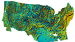
The data available here are a compilation of digitally converted analog magnetic field intensity maps. These maps are either USGS or publicly accessible publications. They were generated as needed to fulfill USGS project requirements.
|
