 Introduction Introduction
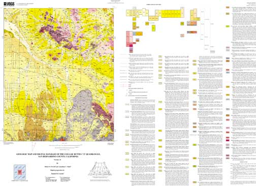
The Southern California Areal Mapping Project (SCAMP) of Geologic Division has undertaken regional geologic mapping investigations in the Lucerne Valley area co-sponsored by the Mojave Water Agency and the San Bernardino National Forest. These investigations span the Lucerne Valley basin from the San Bernardino Mountains front northward to the basin axis on the Mojave Desert floor, and from the Rabbit Lake basin east to the Old Woman Springs area. Quadrangles mapped include the Cougar Buttes 7.5' quadrangle, the Lucerne Valley 7.5' quadrangle (Matti and others, in preparation b), the Fawnskin 7.5' quadrangle (Miller and others, 1998), and the Big Bear City 7.5' quadrangle (Matti and others, in preparation a). The Cougar Buttes quadrangle has been mapped previously at scales of 1:62,500 (Dibblee, 1964) and 1:24,000 (Shreve, 1958, 1968; Sadler, 1982a). In line with the goals of the National Cooperative Geologic Mapping Program (NCGMP), our mapping of the Cougar Buttes quadrangle has been directed toward generating a multipurpose digital geologic map database. Guided by the mapping of previous investigators, we have focused on improving our understanding and representation of late Pliocene and Quaternary deposits. In cooperation with the Water Resources Division of the U.S. Geological Survey, we have used our mapping in the Cougar Buttes and Lucerne Valley quadrangles together with well log data to construct cross-sections of the Lucerne Valley basin (R.E. Powell, unpublished data, 1996-1998) and to develop a hydrogeologic framework for the basin. Currently, our mapping in these two quadrangles also is being used as a base for studying soils on various Quaternary landscape surfaces on the San Bernardino piedmont (Eppes and others, 1998). In the Cougar Buttes quadrangle, we have endeavored to represent the surficial geology in a way that provides a base suitable for ecosystem assessment, an effort that has entailed differentiating surficial veneers on piedmont and pediment surfaces and distinguishing the various substrates found beneath these veneers.
|
First posted May 24, 2000
Files for Viewing and Plotting
Visit the GeoScience Node of the National Spatial Data Clearinghouse to find other geologic-map datasets in southern California or elsewhere in the Nation
Part or all of this report is presented in Portable Document Format (PDF). For best results viewing and printing PDF documents, it is recommended that you download the documents to your computer and open them with Adobe Reader. PDF documents opened from your browser may not display or print as intended. Download the latest version of Adobe Reader, free of charge.
|

